Illustrated Overhead Marina Map
For information on Upton Marina please visit Tingdene-Marinas.co.uk/marinas/upton-marina/
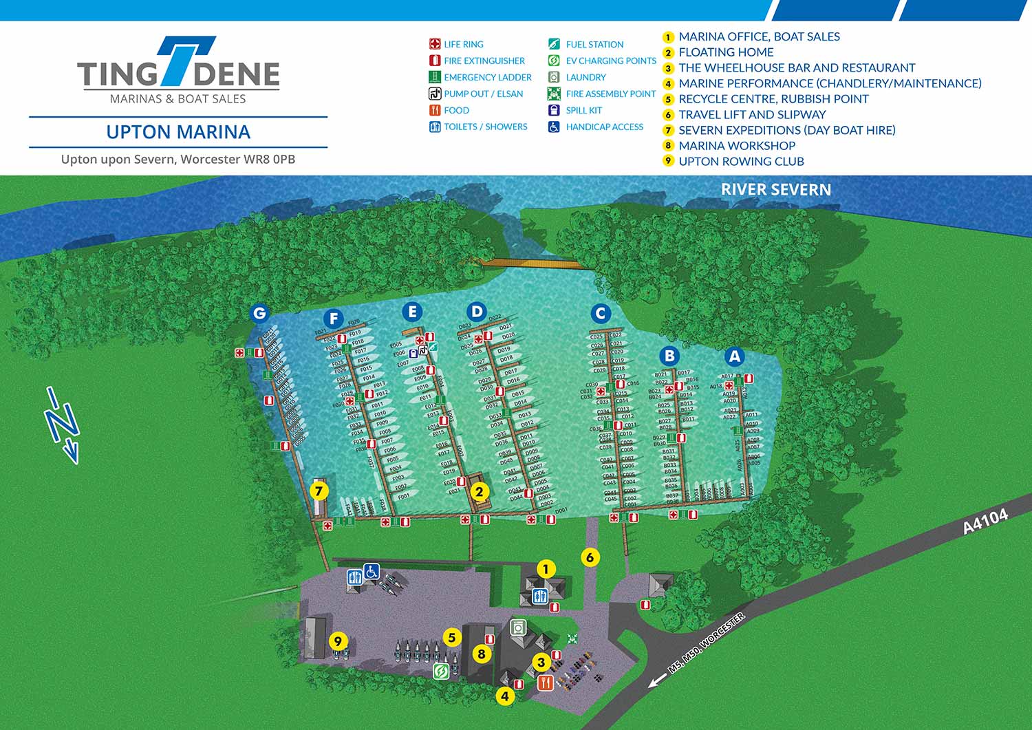
Upton Marina is a well established inland marina offering secure pontoon and bankside moorings for a wide range of boats, along with hardstanding storage and dedicated visitor berths. Situated on the River Severn, the longest river in Britain, the marina enjoys a highly connected location. It lies just south of the historic city of Worcester and north of Tewkesbury, with extensive inland waterways that make much of England accessible by boat from Upton upon Severn.
Escape Key Graphics created this illustrated marina map to support both clear communication and efficient day to day operations. The layout presents the marina in a clean, easy to understand overhead view that helps staff and visitors quickly orient themselves. Slips, access points, and key areas are clearly defined, making the map useful for wayfinding while also reinforcing the professional presentation of the marina.
In addition to guest use, the map was designed as a practical management tool. Tingdene staff plan to produce a metal display and use magnetic labels to indicate the current status of individual slips. This system allows availability and occupancy to be updated at a glance, improving organization and internal communication. A well designed illustrated map like this supports smoother operations while also serving as a polished visual asset for marketing and on site display.


WORK FOR TINGDENE - COMBINED MARINA AND RESIDENTIAL PARK MAPS:


TINGDENE MARINAS
Tingdene Marinas provides access to some of the most desirable cruising rivers and inland waterways throughout the United Kingdom. Their locations offer high quality facilities, welcoming waterfront bars and restaurants, well equipped boatyards, and knowledgeable marina staff. From narrowboats and barges to riverboats and cruisers, Tingdene Marinas delivers a distinctive boating experience across the UK. Custom illustrated maps like this one help communicate that experience clearly while supporting both customer engagement and operational needs.
The illustrated overhead maps I create for Tingdene Marinas are a practical tool for sales, marketing, and day to day marina management. Designed for clarity and ease of use, the maps present the marina layout in a straightforward overhead view that helps staff, boat owners, and visitors quickly understand slip locations, access routes, amenities, and service areas. Maps like this are commonly used across websites, printed materials, on site signage, and internal management systems, making them a versatile asset for marina operations.
TINGDENE RESIDENTIAL PARKS
Tingdene Residential Parks offer modern, well planned living environments designed exclusively for people over 45 who are seeking a relaxed and comfortable lifestyle. With locations throughout the United Kingdom, their parks are set in a range of attractive coastal, rural, and semi rural settings. Custom illustrated maps like this one help communicate the character and organization of each park while reinforcing Tingdene’s commitment to quality and thoughtful design.
The illustrated overhead maps I create for Tingdene Residential Parks support sales, marketing, and day to day site management. The maps present the park layouts in a clear and accessible overhead view, making it easy for prospective residents, staff, and visitors to understand plot locations, internal roads, green spaces, and shared amenities. Maps like this are commonly used across websites, printed brochures, on site signage, and internal planning tools, making them a flexible resource for both promotion and operations.
EXPLORE MY WORK
- Illustration: Discover custom illustrations, book covers, illustrated maps, and architectural renderings.
- Fine Art: Browse original paintings and drawings, view the Custom Halftone Series, or check out mural projects.
- Graphic Design & Motion: See the graphic design collection, then dive into motion design and animated illustrations.
- Maps by industry: View illustrated maps tailored for boat shows, resorts, marinas, real estate, transportation, towns, parks, and wayfinding.
- More project types: Explore cover art, vehicle wraps, proposal renderings, and street art.
- Techniques & styles: Work spans vector, isometric, painting, black-and-white, GeoData, overhead maps, and halftones.
- Software expertise: Primary tools include Photoshop, Illustrator, SketchUp Pro, and InDesign, plus Premiere Pro & After Effects for motion.