
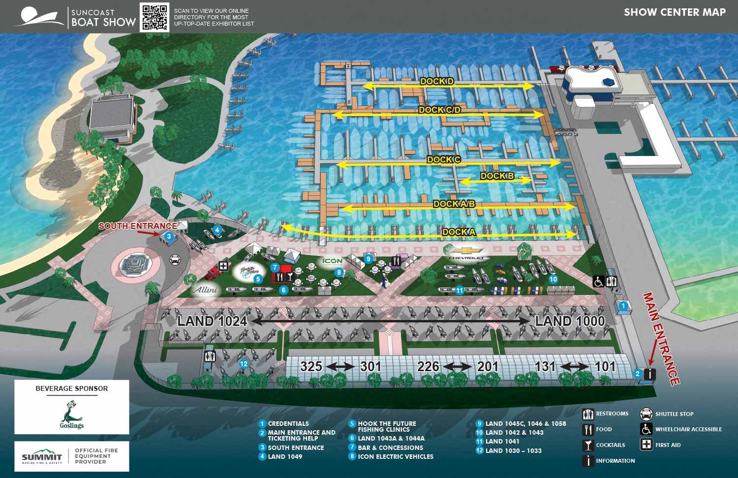
Illustrated Map for the Suncoast Boat Show in Sarasota, Florida
Client: Informa Markets
I am the illustrator and designer of this map. If that is what you are interested in please proceed to explore my site.
If you want the latest and most accurate information about attending the Suncoast Boat Show please visit their official site at SuncoastBoatShow.com
Behind the Map: Suncoast Boat Show 2026
I recently completed the illustrated map for the 2026 Suncoast Boat Show in Sarasota, working with Informa Markets. This was an update year rather than a full rebuild, which is always a good sign. It means the core design holds up.
The map is built on a three dimensional digital model I created when I first started working on this event. That model covers the venue itself, including land features like parking lots and grassy areas, plus buildings and other structures. Each year I update the floating dock positions and land display arrangements. Because the geography is already in place, I only have to adjust elements tied to the current show.
For 2026, the dock layout saw minor tweaks, while land displays had a few more noticeable changes. Entrances are labeled directly on the map. White numerals on blue dots point to show features, and icons help visitors find facilities like restrooms and food stands. I also made the land display numbering more consistent this year, matching the system used for outdoor exhibitors.
The final map appears on the event website, in the mobile app, and on signage around the show. Before the event opens, it serves as a marketing tool, giving attendees a clear picture of what to expect. While other promotional materials focus on atmosphere, a detailed map provides concrete information that helps people plan their day.
MAPS FOR SUNCOAST BOAT SHOW:


PORTFOLIO GALLERIES
- Illustration work: Start with custom illustration and cover design, then view illustrated maps and architectural renderings.
- Fine art: Discover original paintings and drawings, the Custom Halftone Series, and mural projects.
- Design & motion: Check out the graphic design gallery, then move on to motion graphics and animated illustration.
- Maps by sector: I produce illustrated maps for boat shows, resorts, marinas, real estate, transit & parking, towns & cities, parks, and wayfinding systems.
- More creative services: Additional offerings include cover illustration, vehicle wraps, proposal renderings, and street art.
- Artistic methods: My work spans vector art, isometric & axonometric views, traditional painting, black & white illustration, GeoData mapping, overhead perspectives, and halftone effects. Recently I have also begun to utilize AI in some cases.
- Preferred software: I rely on Photoshop, Illustrator, SketchUp Pro, and InDesign, plus Premiere Pro & After Effects for motion projects.
