
Your Guide to Chicago’s Premier On Water Experience
I'm the guy who makes these maps. If you plan on attending the show please visit the show's website to make sure you're getting all the latest information on The Windy City Boat & Yacht Show at WindyCityBYS.com
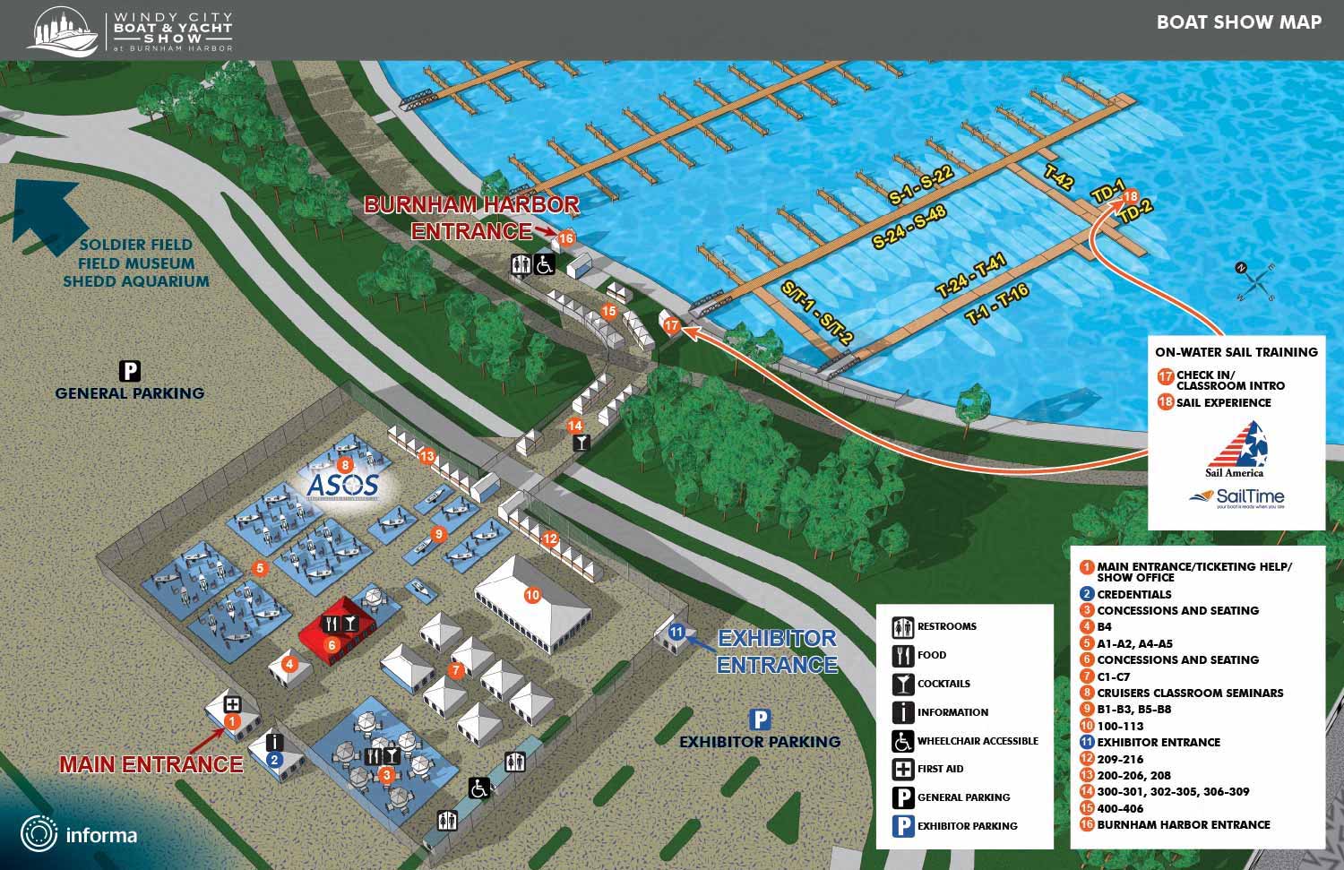
The Windy City Boat & Yacht Show transforms Burnham Harbor into a living showcase of marine innovation and lakeside luxury. Set against the Chicago skyline, this annual gathering brings together an impressive range of vessels, from agile powerboats and classic cruisers to elegant sailboats fresh from the manufacturer and well maintained brokerage models.
On land, the event broadens its appeal with an extensive collection of exhibits. Visitors can explore the latest marine electronics, luxury accessories, performance gear, and essential safety equipment. For those whose passion for the water leans more toward the social side, the show includes live music, chef driven cuisine, and signature cocktails in a relaxed waterfront atmosphere.
A Location Worth Navigating To
Burnham Harbor is the largest harbor in the Chicago Harbor system. The setting alone makes the trip worthwhile. The harbor is surrounded by some of Chicago’s most recognized landmarks, including the Adler Planetarium, Shedd Aquarium, Field Museum, Soldier Field, and McCormick Place. For those arriving by Metra, the 18th Street Station is just over a half mile away, and the harbor is also accessible by car, rideshare, bike, and water taxi.
Why an Illustrated Map Matters
A basic site diagram or utility plan could point someone to a restroom or an exit. But a major show like this one deserves a better kind of guide. Standard technical drawings are often hard to read at a glance, and they rarely capture the energy of an event or help build excitement before a visitor even steps onto the docks.
That is where a custom illustrated map becomes a strategic asset. A well crafted map does more than show locations. It creates a visual story, reinforces a professional identity, and turns wayfinding into a natural part of the experience. I am John Potter of Escape Key Graphics. I specialize in illustrated navigation tools for major boat shows, including the maps I developed for the Miami and Fort Lauderdale International Boat Show. The principles behind those maps, clarity, smart branding, and visual appeal, apply directly to an event of Chicago’s scale.
A thoughtfully designed map for the Windy City Boat & Yacht Show serves several real world purposes. It helps guests plan their day by clearly marking in water displays, land exhibits, dining areas, and key amenities. It strengthens the show’s brand by showing attendees and sponsors that every detail has been considered. It improves crowd flow by providing a single clear reference point, which reduces confusion at busy intersections and demo docks. And it works as a marketing tool before the show even opens, as visitors study the layout online and begin mapping out their must see stops.
What a Great Boat Show Map Includes
Strong event maps balance a wealth of information with a clean, welcoming design. The goal is to give attendees everything they need without overwhelming them. The following table outlines the core layers of information found in the most useful boat show maps, when applicable to the venue.
| Map Layer | Key Components & Purpose. |
| Venue Layout | The foundational geography of the event, including docks, entrance points, and outdoor areas. This layer is the illustration itself. Land Exhibits, Locations for marine accessories, smaller vessels on display, and vendor areas. |
| Activity Hubs | VIP lounges, family zones, demo areas, and places for food and cocktails. |
| Facilities | Ticket sales, restrooms, first aid, and other practical visitor services. |
A great map does not simply tell people where to go. It makes the journey feel like part of the adventure. It reduces frustration, increases engagement, and quietly reassures every guest that they are in good hands.
Charting a Course for a Growing Show
The Windy City Boat & Yacht Show brings the boating lifestyle to life in ways that appeal to longtime owners and curious newcomers alike. Between on the water demonstrations, educational conversations, and elevated social spaces, the event goes well beyond a traditional boat display to celebrate what makes Great Lakes boating unforgettable. As the show continues to grow, the tools that guide its visitors should match its rising stature. A custom illustrated map is a direct investment in the attendee experience, supporting smoother operations, stronger branding, and better reviews.
If you are involved in planning a marine industry event and would like to see how an illustrated map could work for your venue, please take a look at my boat show map portfolio. I am always happy to talk through a specific vision or answer questions about the process.
Maps For The Windy City Boat & Yacht Show:
- About The Windy City Boat & Yacht Show
- The Windy City Boat & Yacht Show: 2026
MAPS FOR BOAT SHOWS IN CHICAGO:


BROWSE MY WORK
- Illustration: Browse custom illustrations, book cover art, illustrated maps, and architectural renderings.
- Fine art: View original paintings and drawings, the Custom Halftone Series, and mural commissions.
- Graphic design & motion: See design projects, then watch motion reels and animated pieces.
- Maps by use case: Explore illustrated maps created for boat shows, resorts, marinas, real estate, transportation & parking, cities & towns, parks, and wayfinding.
- Specialty projects: Also check out cover design, vinyl & vehicle wraps, proposal renderings, and street art.
- Style & technique: Discover vector, isometric, painterly, monochrome, data-driven, bird's-eye, and halftone approaches.
- Tools I use: Everyday software includes Photoshop, Illustrator, SketchUp, and InDesign; motion work relies on Premiere & After Effects. Recently I have begun some work using AI as well.