
Oasis Lounge run by Global Marine Travel at Superyacht Village Map
Illustration and design by John Potter - Escape Key Graphics
Client: Global Marine Travel
Project management by Julia Russell
I illustrate and design these maps. For more (and more up to date) information about The Oasis Lounge at the 2026 Fort Lauderdale International Boat Show please visit their Facebook page at facebook.com/TheOasisLoungeFtLaud/.
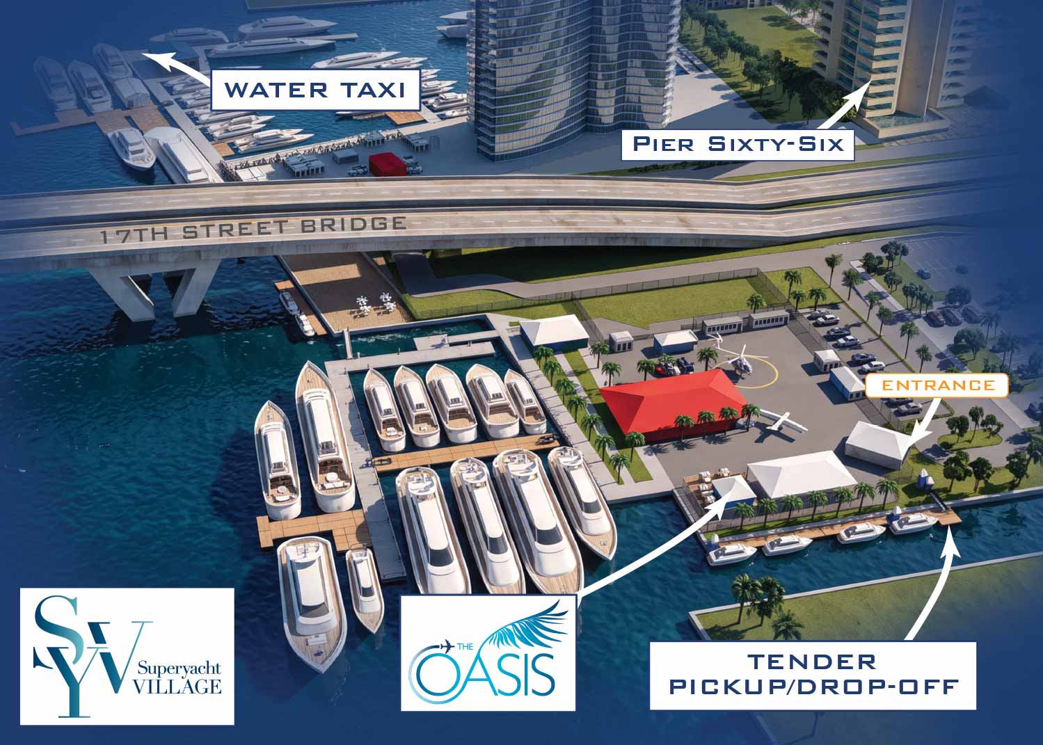
Global Marine Travel uses this map to guide their VIP guests to their exclusive area at the Superyacht Village.
Once again this year, I've collaborated with Global Marine Travel on a set of maps promoting The Oasis Lounge at the Fort Lauderdale International Boat Show. The lounge acts as the Official Hospitality Lounge for Superyacht Captains and Crew, where guests enjoy gourmet boxed lunches, a fully stocked bar, live music, Wi-Fi, and streaming sports. After spending last year at the Swimming Hall of Fame, the lounge now sits at the Las Olas Marina in a fantastic new second-floor space. Alongside that, I made a second map covering their setup at Las Olas Marina.
Building on Previous Years
My work with Global Marine Travel on these maps goes back several years, but this version takes a noticeable step up in visual quality, thanks to a revised workflow. The core method hasn't changed, everything still starts with the three-dimensional digital models I build by hand, but I've added AI into the final rendering stage, which gives the finished maps a livelier, more realistic appearance.
How The Maps Were Made
Everything I use to build the official show maps can also be repurposed to create detailed close-ups of individual areas or views from entirely new directions. That opens the door to a fully customized map with your own branding, built to serve your particular marketing and navigation needs. This project fits that description precisely: a one-of-a-kind, branded piece shaped around a single client's requirements.
For this map, Global Marine Travel wanted their show locations presented from an angle that differed from the primary map. I gave it a custom visual treatment, labeled each feature with their guests in mind, and wove in surrounding context. What resulted is a map designed for their audience alone.
What I Can Provide You
If you're looking for a map that marks the spot of your booth, dock, or exhibit space at any show I cover, reach out. Going custom gets you much more than a trimmed-down section of the main show map, though if a simple zoomed view is all you're after, that's available too. I can give your map its own distinct style, show the venue from angles that draw attention to your space, and keep the focus squarely on what your clients need to know.
WORK FOR GLOBAL MARINE TRAVEL:


BROWSE MY WORK
- Illustration: Browse custom illustrations, book cover art, illustrated maps, and architectural renderings.
- Fine art: View original paintings and drawings, the Custom Halftone Series, and mural commissions.
- Graphic design & motion: See design projects, then watch motion reels and animated pieces.
- Maps by use case: Explore illustrated maps created for boat shows, resorts, marinas, real estate, transportation & parking, cities & towns, parks, and wayfinding.
- Specialty projects: Also check out cover design, vinyl & vehicle wraps, proposal renderings, and street art.
- Style & technique: Discover vector, isometric, painterly, monochrome, data-driven, bird's-eye, and halftone approaches.
- Tools I use: Everyday software includes Photoshop, Illustrator, SketchUp, and InDesign; motion work relies on Premiere & After Effects.
