Oasis Lounge at Las Olas Marina & Superyacht Village Maps- FLIBS 2026
Oasis Lounge at Las Olas Marina & Superyacht Village Maps- FLIBS 2026
Oasis Lounge run by Global Marine Travel at Las Olas Marina & Superyacht Village Maps
Illustration and design by John Potter - Escape Key Graphics
Client: Global Marine Travel
Project management by Julia Russell
I illustrate and design these maps. For more (and more up to date) information about The Oasis Lounge at the 2026 Fort Lauderdale International Boat Show please visit their Facebook page at facebook.com/TheOasisLoungeFtLaud/.
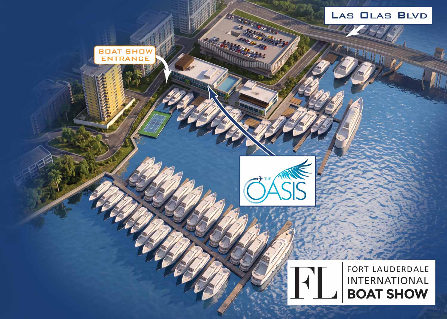
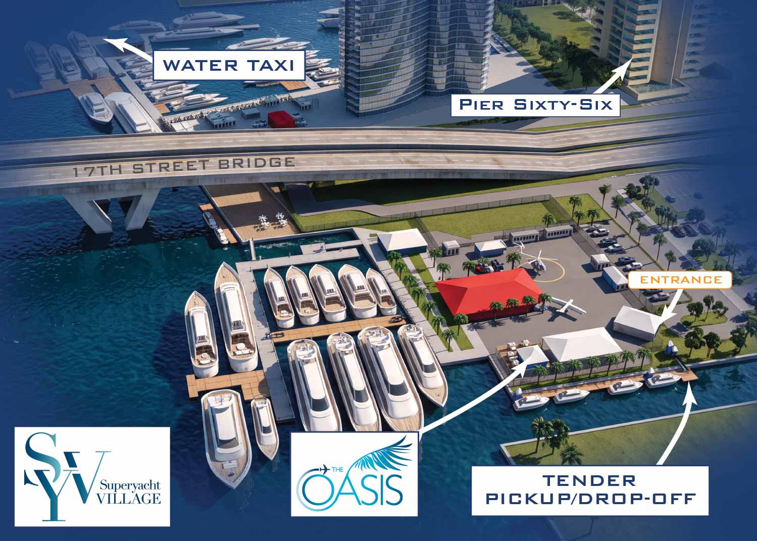
Global Marine Travel uses these maps to guide their VIP guests to their exclusive areas at the Las Olas Marina and Superyacht Village at Pier Sixty Six South.
For another year, I've partnered with Global Marine Travel to produce maps promoting The Oasis Lounge at the Fort Lauderdale International Boat Show. The Oasis Lounge functions as the Official Hospitality Lounge for Superyacht Captains and Crew, providing gourmet boxed lunches, a fully stocked bar, live music, Wi-Fi, and live sports streaming. After last year at the Swimming Hall of Fame, the lounge has relocated to the Las Olas Marina, occupying a terrific new upstairs space. I also created a companion map showing their presence at Superyacht Village at Pier Sixty Six South.
Building on Previous Years
I've been producing these maps for Global Marine Travel for quite a few years, but this edition marks a significant step forward in visual quality thanks to a new workflow. While the maps remain grounded in the three-dimensional digital models I build by hand, I now incorporate AI during the final rendering stage to achieve a more realistic, dynamic look.
How The Maps Were Made
As you may know, I create the official maps for the Fort Lauderdale International Boat Show and most other major boat shows in the United States. Every one of those maps is built from three-dimensional digital models of each venue. I maintain these models on file and update them each year with new dock layouts, exhibitor locations, and supporting details.
The same techniques behind the official maps can also generate zoomed-in views of specific areas or renderings from entirely different angles. That means I can build a highly customized map featuring your own branding, tailored to your specific marketing and wayfinding goals. This map is exactly that: a customized, personalized, branded piece designed around one client's unique needs.
For this project, Global Marine Travel wanted their areas of the boat show depicted from a perspective different from the main map. I applied custom styling, labeled everything for their audience, and included surrounding context. The result is a map that serves their guests and no one else's.
What I Can Provide You
If you need a map showing the location of your booth, dock, or exhibit space at any of the shows I work on, contact me. A custom map can offer far more than a simple zoomed-in version of the main show map—though basic zoomed versions are available if that's all you need. I can deliver a different look and feel, render the venue from angles that highlight your space, and focus on precisely what matters to your clients.

Oasis Lounge Map - FLIBS 2026

Oasis Lounge Map - FLIBS 2025

Oasis Lounge Map - FLIBS 2024

Oasis Lounge Map - FLIBS 2023

Oasis Lounge Map - FLIBS 2022

Oasis Lounge Map - FLIBS 2021

Oasis Lounge Map - FLIBS 2019

Oasis Lounge Map - FLIBS 2018

Bimini Resort and Marina Map

Treasure Cay Resort and Marina Map

Marina Siteplan

Bimini Docks Map

Docks Map

Bahamas Marina Map

Panhandle Marina Map

Conanicut Marina Map

Maryland Marina Map

Resort Marina Map

Sarasota Marina Map

Florida Keys Resort Marina Map

Bahia Mar Marina Map

Newport Yachting Center

Boat Show at Three Marinas

Marina Flamenco Map

The Waterfront & City Commons

Marina Map

Illustrated Map of Marinas

Sea Isle Marina Map

Miami Marinas

Sea Isle and Genting Marina Rendering

Yacht Club Map

Lido Marina Village Boat Show Map

Safe Harbor Sunroad Map
EXPLORE MY PORTFOLIOS
- Illustration: Find custom illustration, book covers, illustrated maps, and architectural rendering.
- Fine Art: Browse original paintings and drawings, the Custom Halftone Series, and murals.
- Graphic Design & Motion: See my graphic design work, plus motion design and animated illustrations.
- Maps by industry: Illustrated maps tailored for boat shows, resorts, marinas, real estate, transit & parking, towns & cities, parks, and wayfinding.
- Other project types: Also available: cover art, vehicle & vinyl wraps, proposal renderings, and street art.
- Techniques: Explore work in vector, isometric & axonometric, painting, black & white, GeoData, overhead, and halftone styles.
- Software: Primary tools: Photoshop, Illustrator, SketchUp Pro, and InDesign. Motion work uses Premiere Pro & After Effects.
