Pride Park in Miami Beach Map for the Miami International Boat Show - 2025
Client: Informa Markets
For information about the Miami International Boat Show and to ensure you're seeing the latest maps and information visit MiamiBoatShow.com
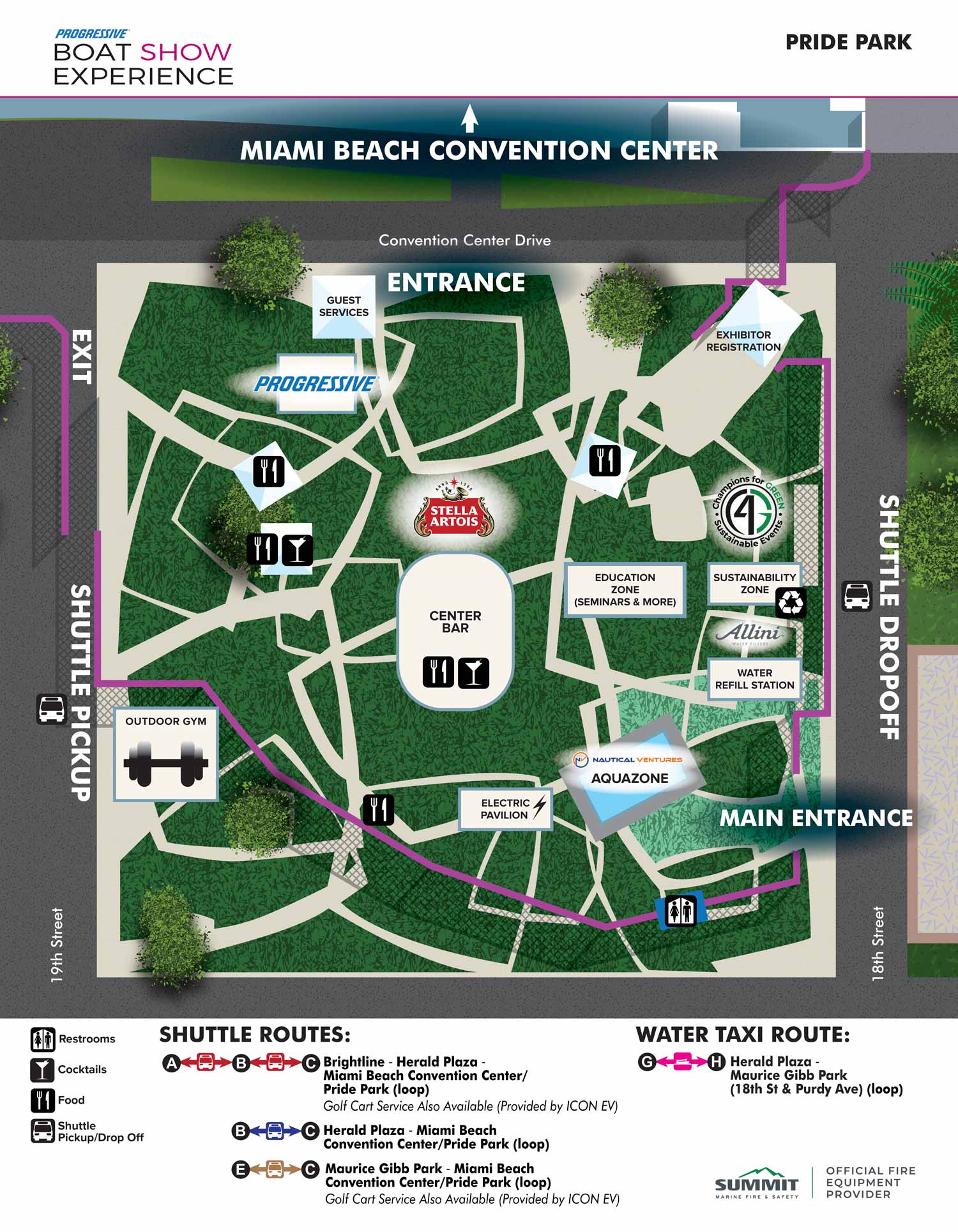
This overhead map was created to help visitors navigate Pride Park during the 2025 Miami International Boat Show and to provide clear orientation between the park and the Miami Beach Convention Center. The map uses color and texture to distinguish different surfaces, such as grassy areas versus paved pathways, while maintaining a clean and uncluttered layout for ease of comprehension.
Key park features, including entrances, exits, and main pathways, are clearly labelled directly on the illustration. Amenities are highlighted using simple, intuitive icons, which are explained in a legend below the map, making it easy for visitors to identify recurring facilities at a glance. Water Taxi and Shuttle routes serving the site are also illustrated with a straightforward graphical system, allowing guests to plan their movements around the show venues efficiently.
Designed with both clarity and usability in mind, this map supports a seamless visitor experience while reflecting the vibrant, active environment of the Miami International Boat Show.
Miami International Boat Show Maps 2025:
Venetian Marina and One Herald Plaza | Museum Park | Miami Beach Convention Center Map | Transportation Map | Pride Park Map | Program LayoutEXAMPLES OF MAPS CREATED FOR MIAMI BOAT SHOWS:


EXPLORE MY PORTFOLIOS
- Illustration: Find custom illustration, book covers, illustrated maps, and architectural rendering.
- Fine Art: Browse original paintings and drawings, the Custom Halftone Series, and murals.
- Graphic Design & Motion: See my graphic design work, plus motion design and animated illustrations.
- Maps by industry: Illustrated maps tailored for boat shows, resorts, marinas, real estate, transit & parking, towns & cities, parks, and wayfinding.
- Other project types: Also available: cover art, vehicle & vinyl wraps, proposal renderings, and street art.
- Techniques: Explore work in vector, isometric & axonometric, painting, black & white, GeoData, overhead, and halftone styles.
- Software: Primary tools: Photoshop, Illustrator, SketchUp Pro, and InDesign. Motion work uses Premiere Pro & After Effects.