Illustrating an Ecosystem: Wetlands Art for Pembroke Pines
Artist, Illustrator: John Potter - Escape Key GraphicsProject Management by Holly Bonkowski - Assistant Director of Cultural Arts - City of Pembroke Pines
Client: City of Pembroke Pines


If you are using a device other than your phone to view this you can scan the QR code and you can test it with the image above. This will also save you some data if you have a WIFI connection right now.

This illustration is part of a significant public art program developed for the City of Pembroke Pines, Florida. The initiative repurposes municipal utility boxes at prominent intersections, transforming standard infrastructure into accessible platforms for community art. By applying custom illustrated vinyl wraps, the city adds layers of visual interest and local narrative to its streetscapes.
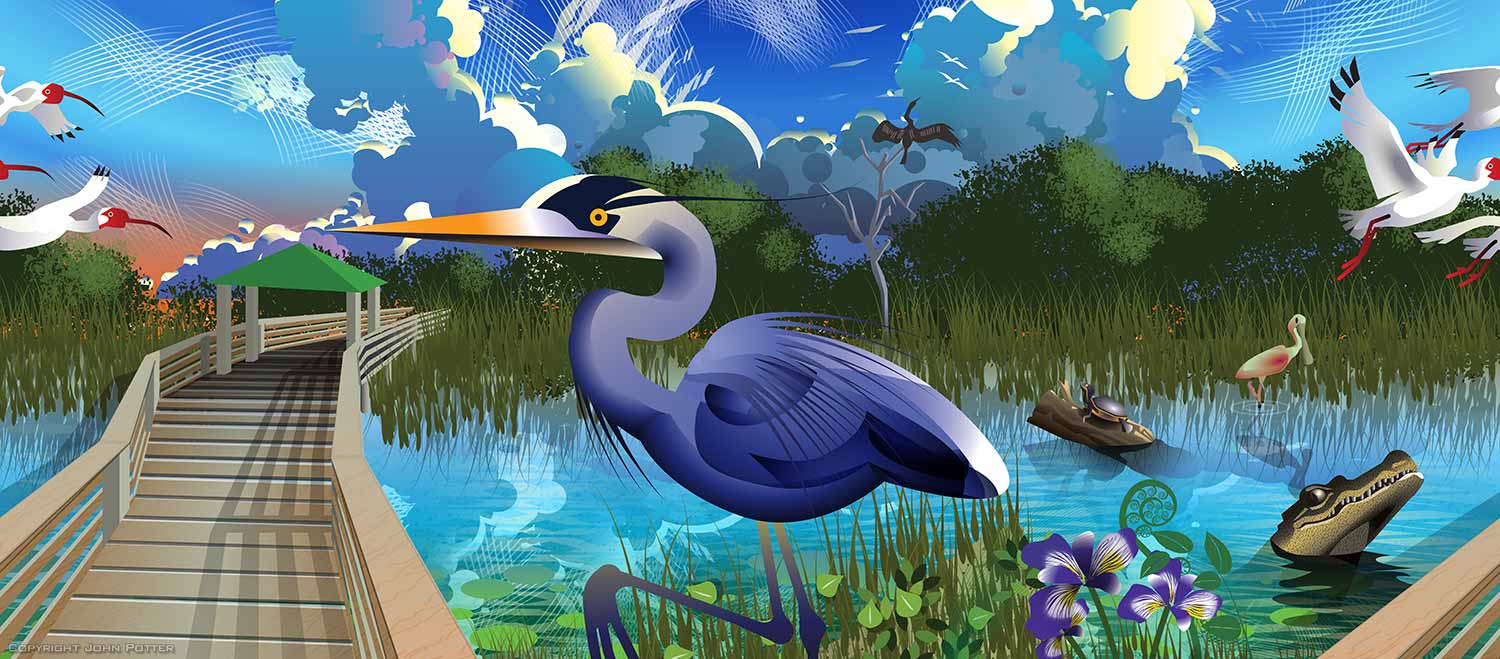
This specific piece focuses on the wetlands ecosystem, a cornerstone of South Florida's natural identity. The artwork serves a dual purpose: beautifying a functional object while quietly educating the public about the region's vital and characteristic environment. It supports the city's commitment to creating a unified, engaging public realm that reflects its unique setting.
From Field to Final Wrap: A Precise Illustrative Process
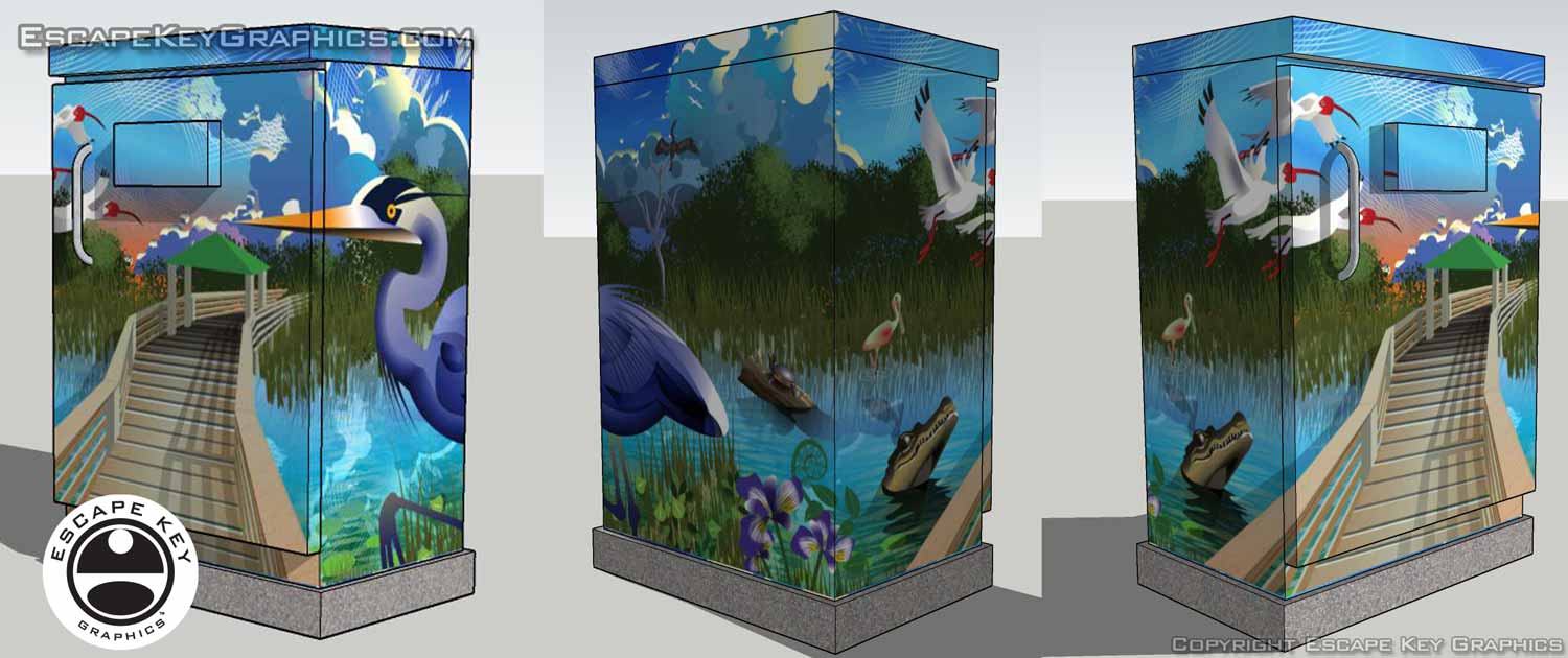
The translation of an artistic concept into a durable public installation requires careful planning. Every project starts with an on site visit. I document the exact utility box, capturing precise dimensions, photographing its condition, and noting the placement of all doors and hardware.
This information becomes the foundation for a technical design phase. I create a detailed scaled drawing and a custom three dimensional model in SketchUp. This modeling step is essential, as it allows me to compose the illustration as a continuous wrap that flows logically over every surface, corner, and access panel. By resolving spatial challenges digitally, I ensure the final artwork presents a seamless and balanced composition from every vantage point, whether seen by a driver or a pedestrian.
A Natural Feature at a Key Intersection
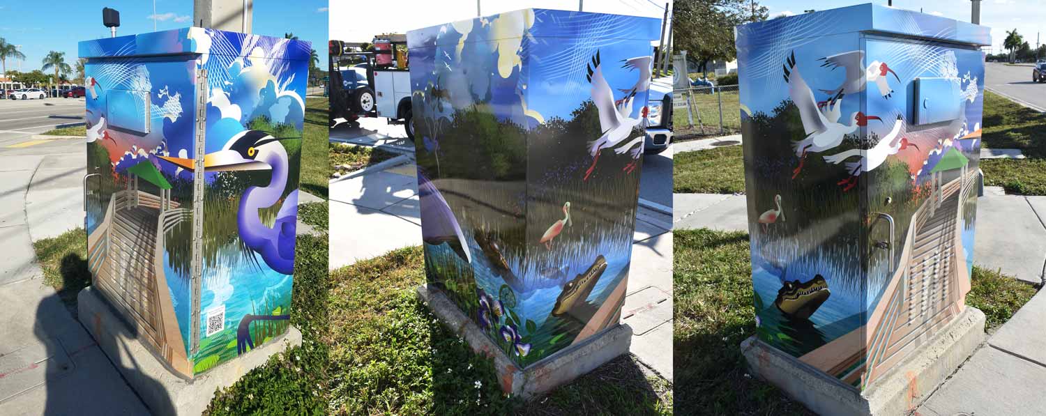
This wetlands illustration is installed at the southeast corner of Pines Boulevard and Northwest 172nd Avenue. Its location along a well traveled corridor demanded a design that was both aesthetically striking and communicatively clear. The artwork uses a vibrant, naturalistic color palette and detailed illustrative style to depict native flora and fauna, creating an engaging visual reference that connects the community to its surrounding environment. This project demonstrates how targeted illustration can enhance municipal identity, promote environmental awareness, and create lasting visual value in shared spaces.
An Interactive Layer of Discovery
To add a dimension of modern engagement, this utility box includes an augmented reality feature. A QR code is integrated into the design. By scanning this code with the free EyeJack app on a smartphone, viewers can download a file that unlocks an animated layer over the illustration, bringing an element of the wetlands scene to life.
A quick note: I am the artist and illustrator for the core artwork. The augmented reality technology is provided by the third party EyeJack platform, and I am not affiliated with their application.
This project highlights the role of illustration in connecting communities to their environment. To see more examples of artwork designed for public spaces and environmental themes, please visit my full Illustration Portfolio.
EyeJack in action on site:
CITY OF PEMBROKE PINES UTILITY BOX ILLUSTRATIONS:


VECTOR ILLUSTRATIONS:
(Created using Adobe Illustrator)


VECTOR ILLUSTRATED MAPS:


PORTFOLIOS
- Illustration Portfolio: Start here for custom illustration and book covers. You can also browse illustrated maps and architectural rendering.
- Fine Art: I offer original paintings and drawings, including my Custom Halftone Series. You will also find mural work here.
- Graphic Design & Motion: View my graphic design portfolio. After that, explore motion design and animated illustrations.
- Maps by application: I create illustrated maps for boat shows, resorts, marinas, real estate, transportation, transit and parking, towns and cities, parks, and wayfinding.
- Additional project types: I also produce cover illustration, vehicle and vinyl wraps, proposal renderings, and street art.
- Illustration methods: My techniques include vector, isometric and axonometric, painting, black and white, GeoData maps, overhead maps, and custom halftones.
- Software portfolios: I work primarily in Adobe Photoshop, Adobe Illustrator, SketchUp Pro, and Adobe InDesign. For motion projects, I use Premiere Pro and After Effects.