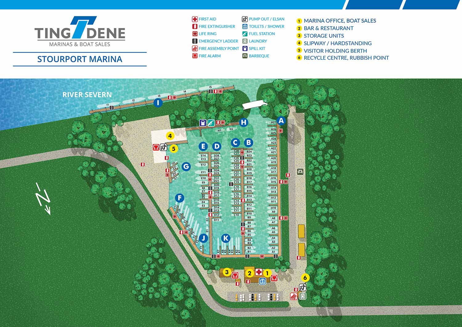
Illustrated Overhead Marina Map
Client: Tingdene Marinas & Boat Sales
For information on Stourport Marina please visit Tingdene-Marinas.co.uk/marinas/stourport-marina/
Stourport Marina is located in the Worcestershire countryside on the River Severn, with convenient access from the M5 and M42 motorways. Situated around twenty miles south of Birmingham, the marina is well placed for visitors travelling from across the Midlands and beyond. Its connection to the Staffordshire and Worcestershire Canal makes it an excellent base for inland cruising, with routes that open up much of the national canal network and onward journeys toward the Welsh borders and the South West. The setting combines practical accessibility with the calm character of a rural riverside marina, making it appealing to both long term berth holders and visiting boaters.
This project features a detailed illustrated overhead map created from a digital three dimensional model of the marina. While clearly illustrative, the visual style is deliberately restrained to ensure clarity and ease of use. Berths and key locations are marked with numbered yellow reference points, while marina amenities are shown using clear, easy to recognise icons. Safety features such as life rings and fire extinguishers are also highlighted, helping the map function as a reliable navigational and orientation tool for staff and visitors alike.
The map has been designed to serve both operational and marketing purposes. Stourport Marina plans to produce a durable metal display that allows magnetic labels to be placed over individual slips, making it a flexible and practical marina management resource. At the same time, the illustrated map supports marketing and visitor communications by presenting the marina in a professional, welcoming, and easy to understand format. Custom illustrated maps like this are an effective way for marinas to improve wayfinding, streamline day to day operations, and enhance their public image.
If you need a similar map please contact me.


WORK FOR TINGDENE - COMBINED MARINA AND RESIDENTIAL PARK MAPS:


TINGDENE MARINAS
Tingdene Marinas provides access to some of the most desirable cruising rivers and inland waterways throughout the United Kingdom. Their locations offer high quality facilities, welcoming waterfront bars and restaurants, well equipped boatyards, and knowledgeable marina staff. From narrowboats and barges to riverboats and cruisers, Tingdene Marinas delivers a distinctive boating experience across the UK. Custom illustrated maps like this one help communicate that experience clearly while supporting both customer engagement and operational needs.
The illustrated overhead maps I create for Tingdene Marinas are a practical tool for sales, marketing, and day to day marina management. Designed for clarity and ease of use, the maps present the marina layout in a straightforward overhead view that helps staff, boat owners, and visitors quickly understand slip locations, access routes, amenities, and service areas. Maps like this are commonly used across websites, printed materials, on site signage, and internal management systems, making them a versatile asset for marina operations.
TINGDENE RESIDENTIAL PARKS
Tingdene Residential Parks offer modern, well planned living environments designed exclusively for people over 45 who are seeking a relaxed and comfortable lifestyle. With locations throughout the United Kingdom, their parks are set in a range of attractive coastal, rural, and semi rural settings. Custom illustrated maps like this one help communicate the character and organization of each park while reinforcing Tingdene’s commitment to quality and thoughtful design.
The illustrated overhead maps I create for Tingdene Residential Parks support sales, marketing, and day to day site management. The maps present the park layouts in a clear and accessible overhead view, making it easy for prospective residents, staff, and visitors to understand plot locations, internal roads, green spaces, and shared amenities. Maps like this are commonly used across websites, printed brochures, on site signage, and internal planning tools, making them a flexible resource for both promotion and operations.
EXPLORE MY WORK
- Illustration: Discover custom illustrations, book covers, illustrated maps, and architectural renderings.
- Fine Art: Browse original paintings and drawings, view the Custom Halftone Series, or check out mural projects.
- Graphic Design & Motion: See the graphic design collection, then dive into motion design and animated illustrations.
- Maps by industry: View illustrated maps tailored for boat shows, resorts, marinas, real estate, transportation, towns, parks, and wayfinding.
- More project types: Explore cover art, vehicle wraps, proposal renderings, and street art.
- Techniques & styles: Work spans vector, isometric, painting, black-and-white, GeoData, overhead maps, and halftones.
- Software expertise: Primary tools include Photoshop, Illustrator, SketchUp Pro, and InDesign, plus Premiere Pro & After Effects for motion.