Custom Illustrated Map - Map of a Boat Show in Palm Beach as an Illustration
Maps For Palm Beach International Boat Show:
- Main Map: 2024 | 2023 | 2022 | 2021 | 2020 | 2019 | 2018 | 2017 | 2016 | 2015 | 2014 | 2013| 2012 | 2011
- Transit & Parking Map: 2024 | 2023 | 2022 | 2020 | 2018
- Video: 2013
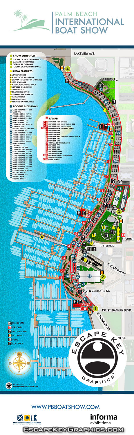
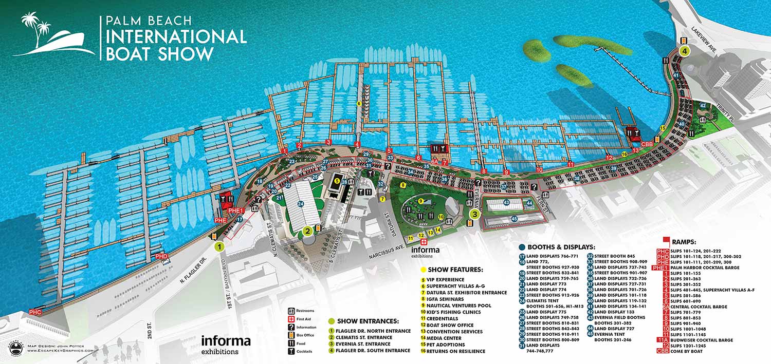
I've updated the illustrated aerial maps I created for the Palm Beach International Boat Show to reflect all of the improvements that Informa has achieved for 2018. The maps continue to be a vital part of the boat show's organization and leads guests to their favorite vendors and helps them discover new ones, not to mention find the bathrooms.
Based on CAD drawings supplied by the client I have created a 3D model that I modify as necessary from year to year and change the rendering style and angle as needed. This year's map isn't a huge departure from last year's, but this is partially due to the fact that previous year's maps have been very successful and required little modification. Thanks to the dedicated staff at Informa updating the maps was a pleasure.
In addition to the main map I created a new parking map, updated three tent detail maps for the program, created new main map signs in two sizes for north facing and south facing as well as a Seminar Schedule sign and did layout of the Z Card folding handout map. I hope you enjoy seeing my map work at the show. If you are interested in having any similar work done please contact me.
CUSTOM BOAT SHOW MAPS:


BOAT SHOW MAPS ARTICLE - SOUTHERN BOATING MAGAZINE 2016:
"Navigating Miami’s multiple venues is easier when you use a map. If you’re at Yachts Miami Beach – formerly The Miami Yacht and Brokerage Show – the man behind those maps is John Potter of Escape Key Graphics, who created his first boat show map for the 201 Fort Lauderdale Int’l. Boat Show. It wasn’t long before the creative concept spread. Less intimidating than site plans and more easier to follow than an aerial photography, Potter’s maps now grace the Stuart Boat Show, St. Petersburg Power & Sailboat Show in Florida and International Boat Shows like Newport, Palm Beach and Panama. His work on these shows frequently extends to many maps such as detailed area maps and transit maps. Potter’s maps can also be seen beyond the yachting industry in theme parks, resorts, wildlife sanctuaries, municipalities, campuses and gardens including Flamingo Gardens, Dinosaur World parks or The Dover International Speedway."
VIDEOS:


PORTFOLIOS:
- Illustration Portfolio
- Illustrated Maps Portfolio
- Fine Art
- Graphic Design Portfolio
- Motion Design
- Animated Illustrations
- Murals
- Architectural Rendering Portfolio
- Posters Portfolio
By Software Used:
By Application or Use:
- Boat Show Map Portfolio
- Resort Map Illustrations Portfolio
- Marina Maps Portfolio
- Transit, Parking and Transportation Maps Portfolio
- Town and City Maps Portfolio
- Cover Illustration Portfolio
- Vehicle Wrap & Vinyl Wrap Portfolio
- Illustrated Park Maps Portfolio
- Wayfinding Maps Portfolio
- Proposal Renderings Portfolio
- Street Art
- Real Estate Maps Portfolio