Map of a Boat Show in Palm Beach as an Illustration
Client: Show Management

Map of the 2017 Palm Beach International Boat Show at Waterfront Commons
This illustrated map depicts the layout of the 2017 Palm Beach International Boat Show at Waterfront Commons in West Palm Beach, Florida.
As with previous projects, the map is rendered from the three dimensional digital master model I maintain for this venue. The viewing angle and magnification remained consistent with the prior edition. This year, I made deliberate artistic adjustments to the presentation. I reduced the visual emphasis on the surrounding neighborhood more than usual and altered the lighting to evoke a later time of day, creating a golden hour atmosphere with long shadows extending across the water. I also increased the brightness and saturation slightly, which began to align the visual tone more closely with the consistent branding style that would develop in subsequent years. The map also incorporated the necessary practical updates, including revisions to floating dock arrangements and exhibitor tent placements.
The map keying system was retained for user familiarity. It employs three distinct colors of numbered dots to easily differentiate between entrances, featured areas, and exhibitor booths. Access ramps continued to be marked with lettered red rectangles.
The established three dimensional model system proved its continued value by enabling a fast turnaround and helping to guarantee accuracy. The initial investment of time and effort in building the model has yielded significant efficiency benefits year after year. The minimal need for dramatic stylistic changes each season indicated that the design had achieved an effective look and feel, with an illustration style and keying system that worked well and that attendees had become comfortable using.
This map served multiple functions for the event. It was utilized on the official website, in general marketing materials, on onsite signage, within the mobile application, and as a printed folding Z Card map.
Maps of this kind allow visitors to visualize the event ahead of time. While many event marketing tools aim to sell a feeling or energy, they often lack practical information. Illustrated maps provide a visually appealing solution that also delivers concrete details for anyone considering attendance. They convey a sense of the event's scale and location, as well as what to expect in terms of exhibitors and on site amenities. Many of my maps go further by including practical planning information such as parking locations, dedicated transportation routes, and access to essential facilities like restrooms and food service areas.
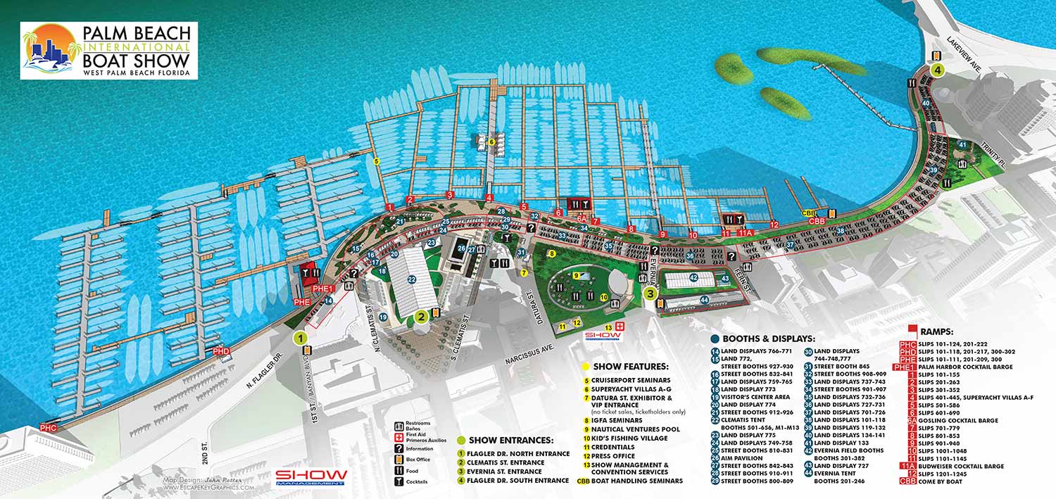
Maps For Palm Beach International Boat Show:
- About The Palm Beach Boat Show
- Main Map: 2025 | 2024 | 2023 | 2022 | 2021 | 2020 | 2019 | 2018 | 2017 | 2016 | 2015 | 2014 | 2013| 2012 | 2011
- Transit & Parking Map: 2025 | 2024 | 2023 | 2022 | 2020 | 2019 | 2018 | 2016
- Program Layout: 2025 | 2024
- Video: 2013
Palm Beach International Boat Show: A Premier Marine Event & Showcase for Custom Map Design:
The Palm Beach International Boat Show (PBIBS) is one of the most prestigious and influential boat shows in the United States, attracting marine enthusiasts, yacht buyers, industry professionals, and visitors from around the world each year. Held along Flagler Drive in downtown West Palm Beach, Florida, this waterfront event features an extraordinary display of luxury vessels, marine accessories, and lifestyle experiences - all set against the scenic backdrop of the Intracoastal Waterway.
Since its inception in 1982, PBIBS has grown into a major economic and cultural driver for the region, with attendance regularly surpassing 55,000 visitors and contributing more than $1 billion in economic impact to Palm Beach County.
World Class Yachts and Marine Innovation
Each year the show presents an impressive lineup of more than 800 to 1,000 boats and vessels, ranging from nimble 8 foot inflatable boats to luxurious superyachts approaching 300 feet in length. With over 600 exhibiting brands and hundreds of boats on display, PBIBS is a premier destination for exploring the latest in marine technology, yacht design, and nautical accessories.
The event also includes specialty showcases such as the Superyacht Show at Palm Harbor, educational seminars on boating and ownership, live activations like the AquaZone, and family-friendly activities including kids’ fishing clinics.
Relaxed Luxury & Local Culture
Unlike some of the larger boat shows in South Florida—such as Miami and Fort Lauderdale—the Palm Beach International Boat Show offers a somewhat more relaxed and refined atmosphere, with easy access to parking, public transit, and downtown amenities. Attendees often combine their day at the show with visits to nearby restaurants, bars, galleries, and shopping districts like CityPlace (now known as Rosemary Square), making it an attractive cultural and social destination for locals and visitors alike.
Art, Innovation & VIP Experiences
PBIBS is not just about boats - it’s also increasingly about lifestyle, luxury, and cultural engagement. VIP ticket holders enjoy access to premium lounges, gourmet dining, and exclusive events that sometimes coincide with related cultural offerings like the Palm Beach Modern + Contemporary (PBM+C) Art Fair, blending the worlds of fine art and luxury yachting.
For art lovers and design conscious attendees, the visual identity of the show is critical - not only in exhibits and signage but in how visitors navigate the expansive layout of boats, exhibits, food and beverage zones, and educational activations.
Featured Map Illustrator: John Potter / Escape Key Graphics
For more than a decade - from 2011 to the present - I have served as the illustrator and designer for the official Palm Beach International Boat Show map. Over the years, I have collaborated closely with the show’s production team at Informa Markets to refine and evolve the show’s visual mapping system to meet the needs of attendees, exhibitors, and staff as the event continues to grow and change.
My contributions have included:
-
Official show map illustration—updated annually to reflect layout changes and new technologies
-
App and digital maps used on mobile platforms during the event
-
Signage and wayfinding graphics throughout the show footprint
-
Transit and foldable maps designed for easy distribution and practical use
Each year’s map reflects improvements in style, software, and usability, ensuring that visitors have a seamless visual experience while navigating the show’s dynamic waterfront layout.
