Transportation and Parking Map for the Palm Beach International Boat Show - 2023
For event information please visit the official site of the boat show.
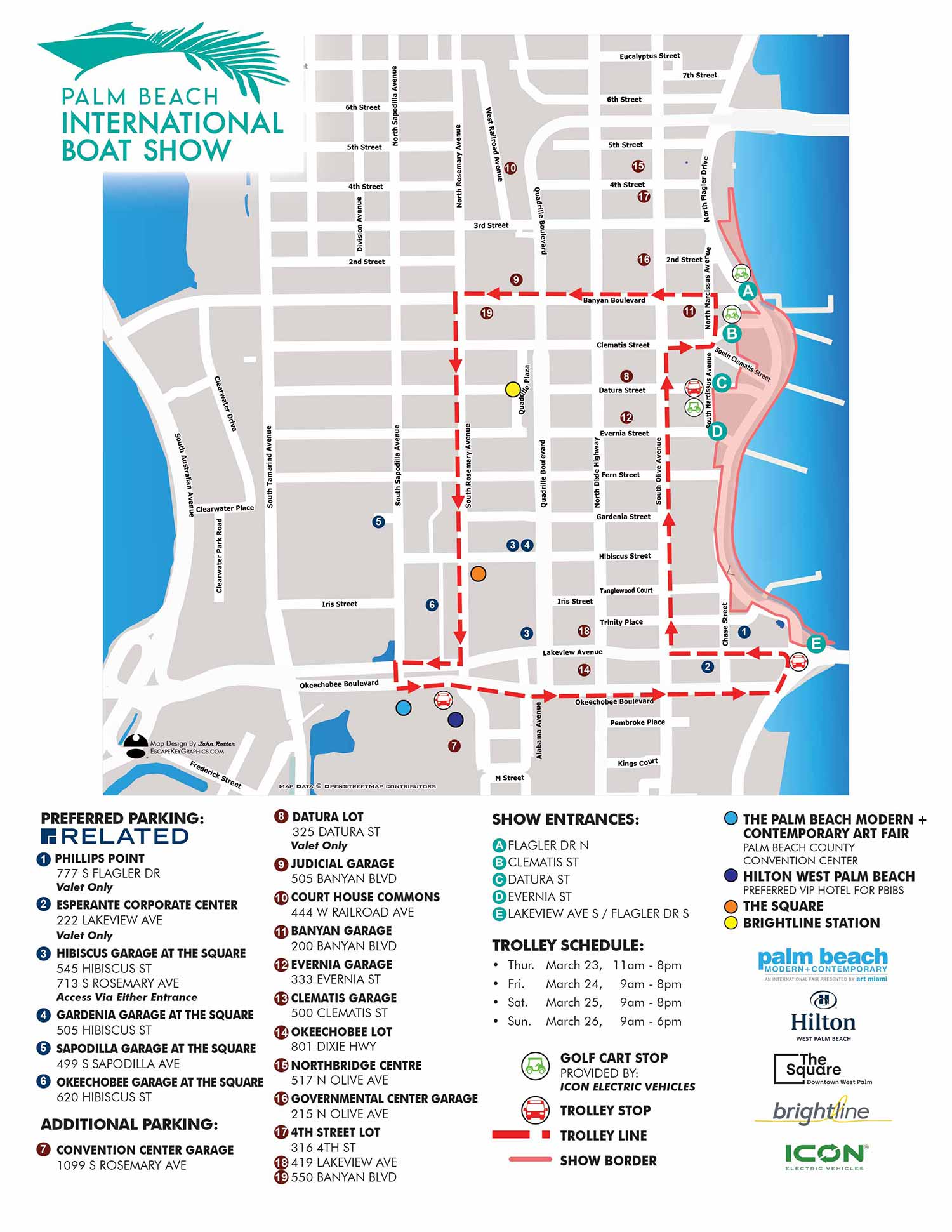
The 2023 Palm Beach International Boat Show Transportation and Parking Map features a notable refinement that addresses a longstanding design consideration. The most immediate change is the orientation of the street grid, which now appears parallel and perpendicular to the page edges. For years, I had presented the streets at their true geographic angle, based on accurate geospatial data, even though this resulted in a subtle, off kilter appearance, as the avenues of West Palm Beach do not run perfectly cardinal north south. In 2023, I made the deliberate design decision to rotate the entire map composition a few degrees. This adjustment prioritizes visual order and immediate readability, creating a cleaner, more regular layout that aligns with user expectations while still accurately representing the spatial relationships between all key features.
It was a big deal to me.
A Clear System for Navigation
The map integrates a comprehensive yet streamlined system for navigating the event's transportation and services. The trolley route was updated, though its overall structure remained consistent with the previous year. Parking options are clearly distinguished: preferred parking is marked with dark blue dots bearing white numerals, while regular parking is indicated by maroon dots with white numerals. Show entrances are keyed with white letters on teal dots. Important local landmarks, including The Hilton West Palm Beach, The Square, the Brightline Station, and the Palm Beach Modern and Contemporary Art Fair, are all clearly marked with their own colored dots. For on the ground transit, golf cart stops (sponsored by Icon Electric Vehicles) and trolley stops are identified with intuitive icons. The show border and trolley line are defined with distinct keyed lines, and the inclusion of the trolley schedule adds valuable practical content for planning.
Strategic Design for Dual Utility
This map is designed to fulfill a dual role with strategic efficiency. In the weeks leading up to the show, it functions as a powerful marketing and planning tool. Available online, it provides potential attendees with concrete, actionable information, allowing them to visualize their visit, choose parking, and understand transportation links. This transforms anticipation into a practical plan, offering substantial value beyond generic promotional imagery. The design achieves a balance of being information rich while maintaining a clean, minimalist, and visually appealing aesthetic.
When the event begins, the same visual asset transitions seamlessly into an essential operational tool, featured in the official program and on onsite signage. Maps of this caliber are not a mere luxury for a major event; they are a critical part of its operational infrastructure. The clarity, accuracy, and professional presentation of the map directly reflect the organization and quality of the event itself.
This project is part of my ongoing work for the Palm Beach International Boat Show. You can learn more about this long term collaboration on my Palm Beach International Boat Show overview page.
For more examples of how detailed informational graphics can enhance your event's communication and visitor experience, please explore my Graphic Design portfolio.
Maps For Palm Beach International Boat Show:
- About The Palm Beach Boat Show
- Main Map: 2026 | 2025 | 2024 | 2023 | 2022 | 2021 | 2020 | 2019 | 2018 | 2017 | 2016 | 2015 | 2014 | 2013| 2012 | 2011
- Transit & Parking Map: 2026 | 2025 | 2024 | 2023 | 2022 | 2020 | 2019 | 2018 | 2016
- Program Layout: 2026 | 2025 | 2024
- Video: 2013


BROWSE MY WORK
- Illustration: Browse custom illustrations, book cover art, illustrated maps, and architectural renderings.
- Fine art: View original paintings and drawings, the Custom Halftone Series, and mural commissions.
- Graphic design & motion: See design projects, then watch motion reels and animated pieces.
- Maps by use case: Explore illustrated maps created for boat shows, resorts, marinas, real estate, transportation & parking, cities & towns, parks, and wayfinding.
- Specialty projects: Also check out cover design, vinyl & vehicle wraps, proposal renderings, and street art.
- Style & technique: Discover vector, isometric, painterly, monochrome, data-driven, bird's-eye, and halftone approaches.
- Tools I use: Everyday software includes Photoshop, Illustrator, SketchUp, and InDesign; motion work relies on Premiere & After Effects.