
Transportation and Parking Map for the Palm Beach International Boat Show - 2018
Client: Informa Markets
For event information and to make sure you're seeing the latest map please visit the official site of the boat show.
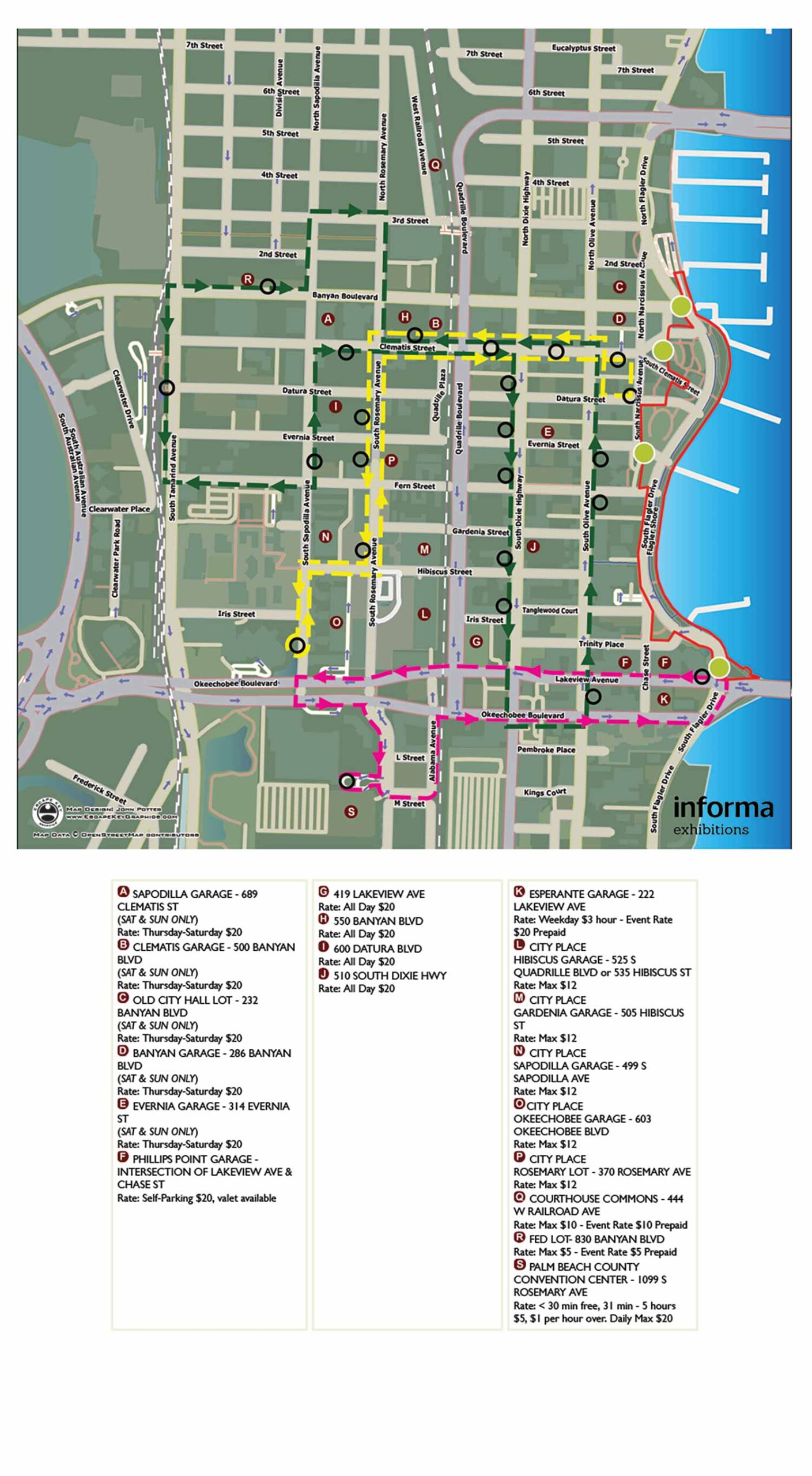
Event Parking & Transportation Map, 2018
The 2018 Palm Beach International Boat Show introduced a new complimentary shuttle service for attendees. This addition transformed the scope of the parking map, requiring it to convey significantly more information while striving to remain clear and easy to read. The challenge was to increase the information density many times over without sacrificing the legibility that defined earlier minimalist versions.
This map was designed for digital use only and was integrated directly into the client's website. To provide detailed viewing, I utilized a software called Zoomify (which no longer exists). This technology allowed users to click on the map image and zoom in to see finer details, a common interactive feature today, though the specific platform is now obsolete. A substantial portion of the interactive menu was built with HTML. I no longer retain all the original components to reconstruct that full functionality, but you can observe that elements like the show border, shuttle routes, pickup and drop off points, and entrances are not explained in a separate key on this static image; they were part of the interactive interface.
The underlying geographic data for the streets and basic layout was sourced from open source data provided by OpenStreetMap. In retrospect, the decision to present a complete street map alongside the specific show information was likely excessive. In subsequent years, we refined the approach by reducing superfluous visual data to create a more focused and effective guide.
The map itself was created entirely in a vector format. Making this detailed map available online before the event served as an excellent planning resource, allowing attendees to understand their transportation and parking options well in advance of their visit.
For more examples of my informational maps, please visit my Maps portfolio.
Maps For Palm Beach International Boat Show:
- About The Palm Beach Boat Show
- Main Map: 2026 | 2025 | 2024 | 2023 | 2022 | 2021 | 2020 | 2019 | 2018 | 2017 | 2016 | 2015 | 2014 | 2013| 2012 | 2011
- Transit & Parking Map: 2026 | 2025 | 2024 | 2023 | 2022 | 2020 | 2019 | 2018 | 2016
- Program Layout: 2026 | 2025 | 2024
- Video: 2013
PORTFOLIO SELECTIONS
- Custom illustration & covers: Featuring bespoke illustration, book and magazine covers, hand-drawn maps, and building renderings.
- Fine art & murals: Including one-of-a-kind paintings and drawings, the Custom Halftone Series, and large-scale murals.
- Design & motion media: Covering graphic design, plus video and motion and animated illustration.
- Mapping by application: Tailored maps for marine events, hospitality, waterfront, property, transit, municipal, recreation, and navigation needs.
- Additional creative work: Includes editorial covers, vehicle graphics, concept renderings, and public art.
- Mediums & formats: Ranging from digital vector and isometric projection to traditional paint, line art, GIS-based, aerial-style, and halftone.
- Software expertise: Proficient in Photoshop, Illustrator, SketchUp, InDesign, and Premiere/After Effects for motion. More recently I have worked with AI.