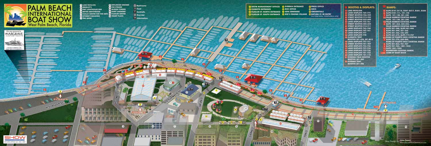
Illustrated boat show picture map showing exhibitor locations
Client: Show Management
 Map in program
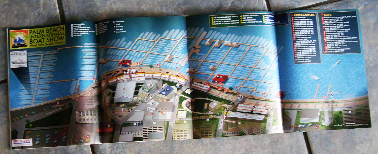
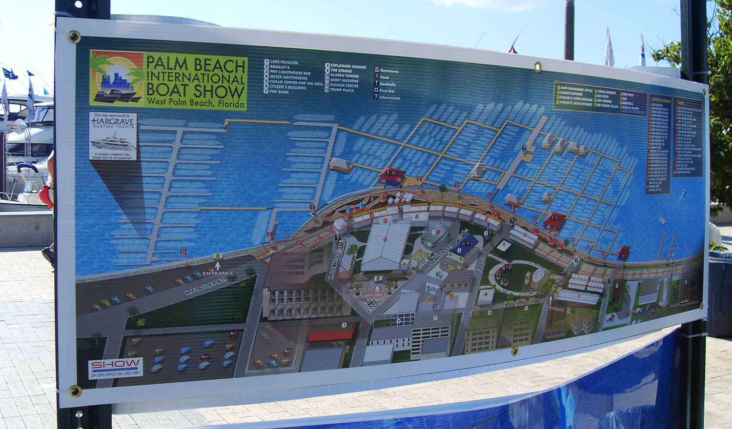 Map as sign
In 2012, the overall design of the Palm Beach International Boat Show map remained largely consistent with the 2011 version, a decision that reflected the strength and effectiveness of the original layout. Updates were focused on practical revisions, primarily adjusting the map key to reflect changes in exhibitors, featured areas, and logistical details for the new show year.
Similar to the Fort Lauderdale map from the same period, this Palm Beach map was produced as a large format foldout. This physical format was intentional, designed to be carried, easily unfolded, and referenced by attendees on site. Together, the 2011 and 2012 editions represent an important early phase in developing a flexible and user focused methodology for illustrated event cartography.
At this stage in my process, the map was created as a vector based axonometric illustration. This technique provided infinite resolution for crisp printing at any size, but the viewing angle was fixed and could not be altered after creation. The entire illustration, including all keying elements and graphics, was developed within Adobe Illustrator.
My working process for these projects is collaborative and detail oriented, a method that has remained largely consistent over time. The client typically supplies CAD drawings of the proposed show layout. I conduct a thorough review of these drawings to identify any discrepancies. Based on this analysis, I then update the positions of floating docks, boat silhouettes, and exhibitor tents. For this project, I modified the existing vector illustration that served as the master file. Depending on the complexity of the changes, I might return to a flat overhead view of the site to make adjustments before converting the artwork back to the axonometric perspective. For simpler revisions, I could edit the illustration directly. The client then reviews this initial updated map, providing feedback on any overlooked details or areas needing clarification.
This initial review is usually followed by receiving updated information for the map keys, often delivered in a text format, which typically leads to further rounds of revision. The event industry is inherently dynamic, with last minute changes being common as new exhibitors register and sponsors adjust their plans close to the event date. It is standard for clients to include disclaimers noting that information is subject to change after materials are printed or posted. This fluid environment is a key reason many illustrators might hesitate to take on such projects. Successfully producing boat show maps requires a graphic artist who is accurate, efficient, and highly adaptable to change.
Illustrated event maps fulfill a unique role by enabling potential visitors to visualize their future experience. Rather than relying on generic stock photography, guests can examine a clear and detailed representation of the event's actual layout. These maps effectively communicate the scale and setting of the event while delivering practical information about amenities, including restroom locations, food access, and transportation or parking options. Consequently, illustrated maps operate as both aesthetically pleasing graphics and genuinely useful informational and marketing tools.
For more examples of my illustrative cartography, please visit my Maps Portfolio.
Maps For Palm Beach International Boat Show:
- About The Palm Beach Boat Show
- Main Map: 2026 | 2025 | 2024 | 2023 | 2022 | 2021 | 2020 | 2019 | 2018 | 2017 | 2016 | 2015 | 2014 | 2013| 2012 | 2011
- Transit & Parking Map: 2026 | 2025 | 2024 | 2023 | 2022 | 2020 | 2019 | 2018 | 2016
- Program Layout: 2026 | 2025 | 2024
- Video: 2013
Palm Beach International Boat Show: A Premier Marine Event & Showcase for Custom Map Design:
The Palm Beach International Boat Show (PBIBS) is one of the most prestigious and influential boat shows in the United States, attracting marine enthusiasts, yacht buyers, industry professionals, and visitors from around the world each year. Held along Flagler Drive in downtown West Palm Beach, Florida, this waterfront event features an extraordinary display of luxury vessels, marine accessories, and lifestyle experiences - all set against the scenic backdrop of the Intracoastal Waterway.
Since its inception in 1982, PBIBS has grown into a major economic and cultural driver for the region, with attendance regularly surpassing 55,000 visitors and contributing more than $1 billion in economic impact to Palm Beach County.
World Class Yachts and Marine Innovation
Each year the show presents an impressive lineup of more than 800 to 1,000 boats and vessels, ranging from nimble 8 foot inflatable boats to luxurious superyachts approaching 300 feet in length. With over 600 exhibiting brands and hundreds of boats on display, PBIBS is a premier destination for exploring the latest in marine technology, yacht design, and nautical accessories.
The event also includes specialty showcases such as the Superyacht Show at Palm Harbor, educational seminars on boating and ownership, live activations like the AquaZone, and family-friendly activities including kids’ fishing clinics.
Relaxed Luxury & Local Culture
Unlike some of the larger boat shows in South Florida—such as Miami and Fort Lauderdale—the Palm Beach International Boat Show offers a somewhat more relaxed and refined atmosphere, with easy access to parking, public transit, and downtown amenities. Attendees often combine their day at the show with visits to nearby restaurants, bars, galleries, and shopping districts like CityPlace (now known as Rosemary Square), making it an attractive cultural and social destination for locals and visitors alike.
Art, Innovation & VIP Experiences
PBIBS is not just about boats - it’s also increasingly about lifestyle, luxury, and cultural engagement. VIP ticket holders enjoy access to premium lounges, gourmet dining, and exclusive events that sometimes coincide with related cultural offerings like the Palm Beach Modern + Contemporary (PBM+C) Art Fair, blending the worlds of fine art and luxury yachting.
For art lovers and design conscious attendees, the visual identity of the show is critical - not only in exhibits and signage but in how visitors navigate the expansive layout of boats, exhibits, food and beverage zones, and educational activations.
Featured Map Illustrator: John Potter / Escape Key Graphics
For more than a decade - from 2011 to the present - I have served as the illustrator and designer for the official Palm Beach International Boat Show map. Over the years, I have collaborated closely with the show’s production team at Informa Markets to refine and evolve the show’s visual mapping system to meet the needs of attendees, exhibitors, and staff as the event continues to grow and change.
My contributions have included:
-
Official show map illustration—updated annually to reflect layout changes and new technologies
-
App and digital maps used on mobile platforms during the event
-
Signage and wayfinding graphics throughout the show footprint
-
Transit and foldable maps designed for easy distribution and practical use
Each year’s map reflects improvements in style, software, and usability, ensuring that visitors have a seamless visual experience while navigating the show’s dynamic waterfront layout.
PORTFOLIOS
- Illustration Portfolio: Start here for custom illustration and book covers. You can also browse illustrated maps and architectural rendering.
- Fine Art: I offer original paintings and drawings, including my Custom Halftone Series. You will also find mural work here.
- Graphic Design & Motion: View my graphic design portfolio. After that, explore motion design and animated illustrations.
- Maps by application: I create illustrated maps for boat shows, resorts, marinas, real estate, transportation, transit and parking, towns and cities, parks, and wayfinding.
- Additional project types: I also produce cover illustration, vehicle and vinyl wraps, proposal renderings, and street art.
- Illustration methods: My techniques include vector, isometric and axonometric, painting, black and white, GeoData maps, overhead maps, and custom halftones.
- Software portfolios: I work primarily in Adobe Photoshop, Adobe Illustrator, SketchUp Pro, and Adobe InDesign. For motion projects, I use Premiere Pro and After Effects.