Map for the Palm Beach International Boat Show - 2025
Client: Informa Markets
For all the latest event information and to be sure you are looking at the latest map revision please visit the official site of the boat show.
If you are interested in hiring me to create an original map or illustration for you please contact me.

Continuity and Precision, Year After Year
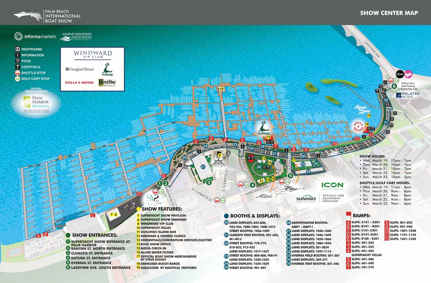
I designed the 2025 Palm Beach International Boat Show map as a direct evolution of the previous year's successful layout. Attendees and organizers have come to expect clear, refined wayfinding, and I meet that expectation by maintaining a consistent visual framework. The familiar aerial angle stays. So does the technique of fading areas outside the show borders. This approach provides immediate familiarity even as the event itself shifts around those fixed reference points.
The Real Work: Annual Revisons
The core challenge every year is accuracy. Floating docks get reconfigured. Exhibitor locations move. The Palm Beach waterfront never stays exactly the same from one show to the next. Consequently, I completely rework the keying system annually. Absolute precision is not optional here. Visitors need to find specific booths, and exhibitors need to know their spot is represented correctly.
A Streamlined, Color Coded System
This year's map uses a clean color coded numerical system. Show entrances appear as white digits on green fields. Key features are black digits on yellow fields. Exhibitor booths and displays carry white digits on blue fields. Access ramps use white letters on red fields. I made one critical design decision. I numbered all points of interest in a single continuous sequence across every category. This eliminates duplicate numbers entirely. Every reference on the map is unique. I also updated the border treatment for exhibitor areas. Previous years outlined them in red. Now I highlight them in blue, creating an intuitive visual link with their corresponding blue key symbol. It is a subtle change, but it makes the system feel cohesive.
Built on a Model I Have Maintained Since 2013
The illustration rests on a durable digital three dimensional model. I originally built this model for the 2013 show, and I have updated it meticulously every year since. I handle modeling and alterations in SketchUp Pro. Kerkythea does the rendering. From there I refine and prepare the scene in Adobe Photoshop. All final graphics, keying, and logo integration happen in Adobe Illustrator. Finally, I lay out the map for publication in the official show program using Adobe InDesign. This pipeline has served me well for over a decade.
Client and Sponsors
I completed this project for Informa Markets. Several sponsors supported the effort, including Palm Harbor Marina, which encompasses the northern section of the map. SYS Yacht Sales, ICON Electric Vehicles, and Summit Fire & Security also contributed. Their participation helps make the map possible year after year.
A Precise Tool for Thousands of Visitors
The 2025 map stands as a precise and polished navigational tool. Thousands of visitors rely on it to navigate one of Florida's premier marine industry events. I take that responsibility seriously, and I approach every annual update with the same level of attention I brought to the very first one.
Maps For Palm Beach International Boat Show:
- About The Palm Beach Boat Show
- Main Map: 2026 | 2025 | 2024 | 2023 | 2022 | 2021 | 2020 | 2019 | 2018 | 2017 | 2016 | 2015 | 2014 | 2013| 2012 | 2011
- Transit & Parking Map: 2026 | 2025 | 2024 | 2023 | 2022 | 2020 | 2019 | 2018 | 2016
- Program Layout: 2026 | 2025 | 2024
- Video: 2013
EXPLORE MY PORTFOLIOS
- Illustration: Find custom illustration, book covers, illustrated maps, and architectural rendering.
- Fine Art: Browse original paintings and drawings, the Custom Halftone Series, and murals.
- Graphic Design & Motion: See my graphic design work, plus motion design and animated illustrations.
- Maps by industry: Illustrated maps tailored for boat shows, resorts, marinas, real estate, transit & parking, towns & cities, parks, and wayfinding.
- Other project types: Also available: cover art, vehicle & vinyl wraps, proposal renderings, and street art.
- Techniques: Explore work in vector, isometric & axonometric, painting, black & white, GeoData, overhead, and halftone styles.
- Software: Primary tools: Photoshop, Illustrator, SketchUp Pro, and InDesign. Motion work uses Premiere Pro & After Effects.