Landscape illustration of an are set up for a boat show
Client: Show Management
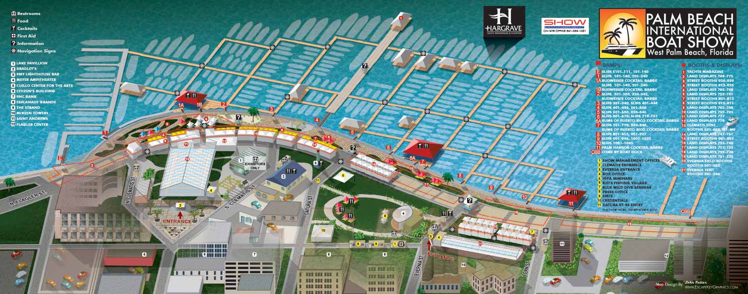
The 2011 Palm Beach International Boat Show marked my first year designing and illustrating an official map for this event. The project drew on methods I had recently used for the Fort Lauderdale International Boat Show, including a fully vector based, axonometric illustration style. The perspective is oriented from land, reflecting the way many visitors naturally approach and enter the show, which helps users align the map with their real world surroundings.
While the overall visual approach was similar to the Fort Lauderdale map, the navigation system was adapted to suit the specific needs of the Palm Beach show. In this case, the map was organized primarily by dock ramp rather than by dock name or area. This project reinforced an important lesson early in my mapping career. Even when working with the same client across multiple events, each show presents unique conditions that can require different organizational strategies. Continuity is valuable, but it must sometimes yield to clarity and practicality.
The map also included a numbered key using yellow markers to identify major points of interest, along with a separate building key using white numbered markers to reference nearby structures for additional orientation. While both systems were clearly differentiated visually, the experience informed later refinements in my approach to reduce potential confusion from multiple numbering sequences. Visitor amenities, particularly those that appeared repeatedly throughout the show, were identified using a clear and intuitive icon system.
Like the Fort Lauderdale International Boat Show map from the same period, this Palm Beach map was produced as a large format foldout, designed to be carried, unfolded, and referenced on site. The project represents an early but important step in the development of a flexible, user focused approach to illustrated event mapping.
Maps For Palm Beach International Boat Show:
- About The Palm Beach Boat Show
- Main Map: 2026 | 2025 | 2024 | 2023 | 2022 | 2021 | 2020 | 2019 | 2018 | 2017 | 2016 | 2015 | 2014 | 2013| 2012 | 2011
- Transit & Parking Map: 2026 | 2025 | 2024 | 2023 | 2022 | 2020 | 2019 | 2018 | 2016
- Program Layout: 2026 | 2025 | 2024
- Video: 2013
Palm Beach International Boat Show: A Premier Marine Event & Showcase for Custom Map Design:
The Palm Beach International Boat Show (PBIBS) is one of the most prestigious and influential boat shows in the United States, attracting marine enthusiasts, yacht buyers, industry professionals, and visitors from around the world each year. Held along Flagler Drive in downtown West Palm Beach, Florida, this waterfront event features an extraordinary display of luxury vessels, marine accessories, and lifestyle experiences - all set against the scenic backdrop of the Intracoastal Waterway.
Since its inception in 1982, PBIBS has grown into a major economic and cultural driver for the region, with attendance regularly surpassing 55,000 visitors and contributing more than $1 billion in economic impact to Palm Beach County.
World Class Yachts and Marine Innovation
Each year the show presents an impressive lineup of more than 800 to 1,000 boats and vessels, ranging from nimble 8 foot inflatable boats to luxurious superyachts approaching 300 feet in length. With over 600 exhibiting brands and hundreds of boats on display, PBIBS is a premier destination for exploring the latest in marine technology, yacht design, and nautical accessories.
The event also includes specialty showcases such as the Superyacht Show at Palm Harbor, educational seminars on boating and ownership, live activations like the AquaZone, and family-friendly activities including kids’ fishing clinics.
Relaxed Luxury & Local Culture
Unlike some of the larger boat shows in South Florida—such as Miami and Fort Lauderdale—the Palm Beach International Boat Show offers a somewhat more relaxed and refined atmosphere, with easy access to parking, public transit, and downtown amenities. Attendees often combine their day at the show with visits to nearby restaurants, bars, galleries, and shopping districts like CityPlace (now known as Rosemary Square), making it an attractive cultural and social destination for locals and visitors alike.
Art, Innovation & VIP Experiences
PBIBS is not just about boats - it’s also increasingly about lifestyle, luxury, and cultural engagement. VIP ticket holders enjoy access to premium lounges, gourmet dining, and exclusive events that sometimes coincide with related cultural offerings like the Palm Beach Modern + Contemporary (PBM+C) Art Fair, blending the worlds of fine art and luxury yachting.
For art lovers and design conscious attendees, the visual identity of the show is critical - not only in exhibits and signage but in how visitors navigate the expansive layout of boats, exhibits, food and beverage zones, and educational activations.
Featured Map Illustrator: John Potter / Escape Key Graphics
For more than a decade - from 2011 to the present - I have served as the illustrator and designer for the official Palm Beach International Boat Show map. Over the years, I have collaborated closely with the show’s production team at Informa Markets to refine and evolve the show’s visual mapping system to meet the needs of attendees, exhibitors, and staff as the event continues to grow and change.
My contributions have included:
-
Official show map illustration—updated annually to reflect layout changes and new technologies
-
App and digital maps used on mobile platforms during the event
-
Signage and wayfinding graphics throughout the show footprint
-
Transit and foldable maps designed for easy distribution and practical use
Each year’s map reflects improvements in style, software, and usability, ensuring that visitors have a seamless visual experience while navigating the show’s dynamic waterfront layout.
CUSTOM BOAT SHOW MAPS:


AXONOMETRIC AND ISOMETRIC ILLUSTRATIONS:


PORTFOLIOS
- Illustration Portfolio: Start here for custom illustration and book covers. You can also browse illustrated maps and architectural rendering.
- Fine Art: I offer original paintings and drawings, including my Custom Halftone Series. You will also find mural work here.
- Graphic Design & Motion: View my graphic design portfolio. After that, explore motion design and animated illustrations.
- Maps by application: I create illustrated maps for boat shows, resorts, marinas, real estate, transportation, transit and parking, towns and cities, parks, and wayfinding.
- Additional project types: I also produce cover illustration, vehicle and vinyl wraps, proposal renderings, and street art.
- Illustration methods: My techniques include vector, isometric and axonometric, painting, black and white, GeoData maps, overhead maps, and custom halftones.
- Software portfolios: I work primarily in Adobe Photoshop, Adobe Illustrator, SketchUp Pro, and Adobe InDesign. For motion projects, I use Premiere Pro and After Effects.