Transportation and Parking Map for the Palm Beach International Boat Show - 2025
Client: Informa Markets
For event information and to make sure you're seeing the latest map please visit the official site of the boat show.
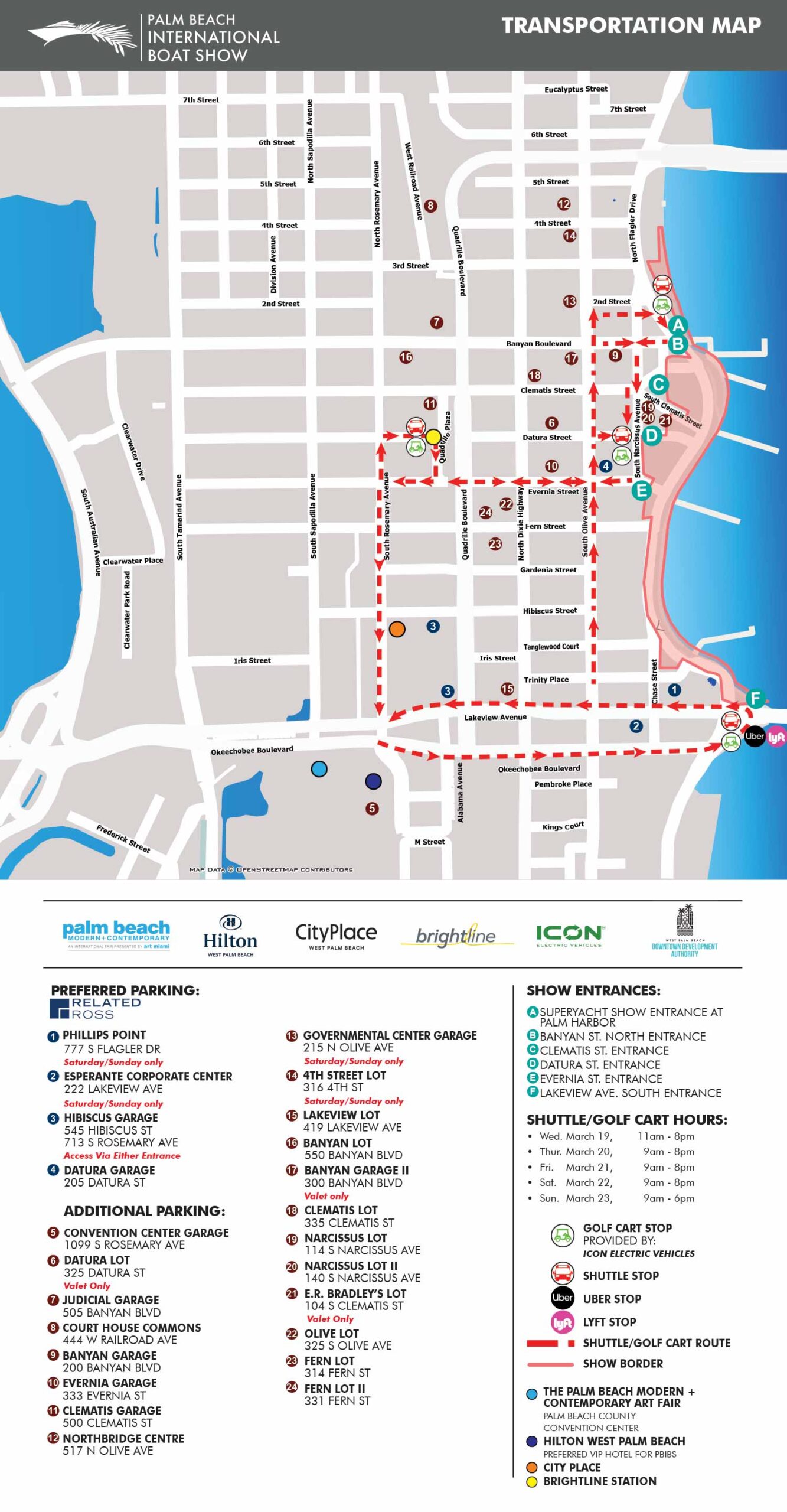
This overhead transit map was updated for the 2025 Palm Beach International Boat Show (originally created in 2018) to help visitors navigate parking, shuttle routes, and key points of interest efficiently. The map highlights main entrances to the show, preferred and additional parking areas, and shuttle stops. Parking locations are identified with numbered, color coded dots that include addresses for easy GPS navigation. Key local destinations, such as Palm Beach Modern + Contemporary and City Place, are indicated with colored dots for reference. Shuttle and transportation routes are shown with dotted lines and arrows to clearly indicate direction, and four alternative local transportation options are represented with intuitive icons.
Unlike my more artistic maps, this map overlays precise information on an overhead street layout, where accuracy of scale and position is critical. The base data was sourced from OpenStreetMap, an open source geodata resource, and refined to remove unnecessary roads that could contribute to visual clutter. This process ensures that only the essential streets, parking, and transit routes are shown, making the map clear and easy to follow. Since its initial development in 2018, the map has been refined each year to reflect route changes and improve usability.
This transit map is an invaluable tool for boat show visitors. It is best accessed online or via a mobile device before heading to the show, allowing guests to plan their route, identify parking, and select the most convenient transportation options. By combining precision with clarity, the map helps ensure a smooth and stress free experience for all attendees.
Maps For Palm Beach International Boat Show:
- About The Palm Beach Boat Show
- Main Map: 2026 | 2025 | 2024 | 2023 | 2022 | 2021 | 2020 | 2019 | 2018 | 2017 | 2016 | 2015 | 2014 | 2013| 2012 | 2011
- Transit & Parking Map: 2026 | 2025 | 2024 | 2023 | 2022 | 2020 | 2019 | 2018 | 2016
- Program Layout: 2026 | 2025 | 2024
- Video: 2013
PORTFOLIOS
- Illustration Portfolio: Start here for custom illustration and book covers. You can also browse illustrated maps and architectural rendering.
- Fine Art: I offer original paintings and drawings, including my Custom Halftone Series. You will also find mural work here.
- Graphic Design & Motion: View my graphic design portfolio. After that, explore motion design and animated illustrations.
- Maps by application: I create illustrated maps for boat shows, resorts, marinas, real estate, transportation, transit and parking, towns and cities, parks, and wayfinding.
- Additional project types: I also produce cover illustration, vehicle and vinyl wraps, proposal renderings, and street art.
- Illustration methods: My techniques include vector, isometric and axonometric, painting, black and white, GeoData maps, overhead maps, and custom halftones.
- Software portfolios: I work primarily in Adobe Photoshop, Adobe Illustrator, SketchUp Pro, and Adobe InDesign. For motion projects, I use Premiere Pro and After Effects.