
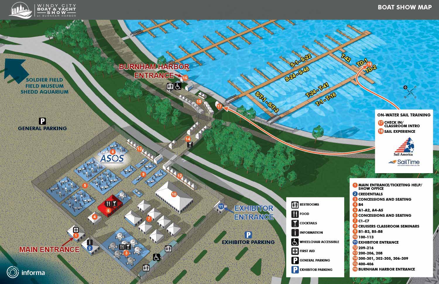
Windy City Boat & Yacht Show - Illustrated Map - 2026
Client: Informa Markets
For information about the Windy City Boat & Yacht Show and to ensure you're seeing the latest maps and information visit WindyCityBYS.com
About the Show
I’m excited to be part of the debut Windy City Boat & Yacht Show in Chicago, IL. Held at Burnham Harbor just south of Soldier Field and near the Field Museum, Shedd Aquarium, and Adler Planetarium—the venue is easily accessible via the 18th Street Metra station or water taxi.
The event features in-water boats up to 75 feet, from powerboats to sailboats, including new models and brokerage vessels. On land, explore the latest in marine tech, accessories, safety gear, and essentials. Whether you’re a seasoned boater or looking for a great day out, this show delivers.
Making the Map
As with Informa shows, this map is built from a 3D digital model I created. I anticipated this event early and modeled a larger area than the final map shows expecting future growth.
I rendered images from the model, then refined them in Photoshop, adding keys, icons, and graphics in Illustrator. I’ve used this technique for years at the Fort Lauderdale, Miami, and Palm Beach boat shows. This map follows a similar scale and layout to the Suncoast show, so I applied the same clear dock numbering and keying.
Uses
This map will appear on the official show website, mobile app, printed materials, and event signage—maximizing its value as both a practical wayfinding tool and an aspirational preview of the experience.
I’m genuinely excited to see boat shows emerging in Chicago. With over 94,000 square miles of freshwater cruising across the Great Lakes—perfect for diving, sailing, fishing, and touring—boating offers a wonderful escape from the city into nature.
Maps For The Windy City Boat & Yacht Show:
- About The Windy City Boat & Yacht Show
- The Windy City Boat & Yacht Show: 2026
MAPS FOR BOAT SHOWS IN CHICAGO:


PORTFOLIO GALLERIES
- Illustration work: Start with custom illustration and cover design, then view illustrated maps and architectural renderings.
- Fine art: Discover original paintings and drawings, the Custom Halftone Series, and mural projects.
- Design & motion: Check out the graphic design gallery, then move on to motion graphics and animated illustration.
- Maps by sector: I produce illustrated maps for boat shows, resorts, marinas, real estate, transit & parking, towns & cities, parks, and wayfinding systems.
- More creative services: Additional offerings include cover illustration, vehicle wraps, proposal renderings, and street art.
- Artistic methods: My work spans vector art, isometric & axonometric views, traditional painting, black & white illustration, GeoData mapping, overhead perspectives, and halftone effects.
- Preferred software: I rely on Photoshop, Illustrator, SketchUp Pro, and InDesign, plus Premiere Pro & After Effects for motion projects.
