Illustrated Overhead Marina Map
Client: Tingdene Marinas & Boat Sales
For information on Hartford Marina please visit Tingdene-Marinas.co.uk/marinas/hartford-marina/
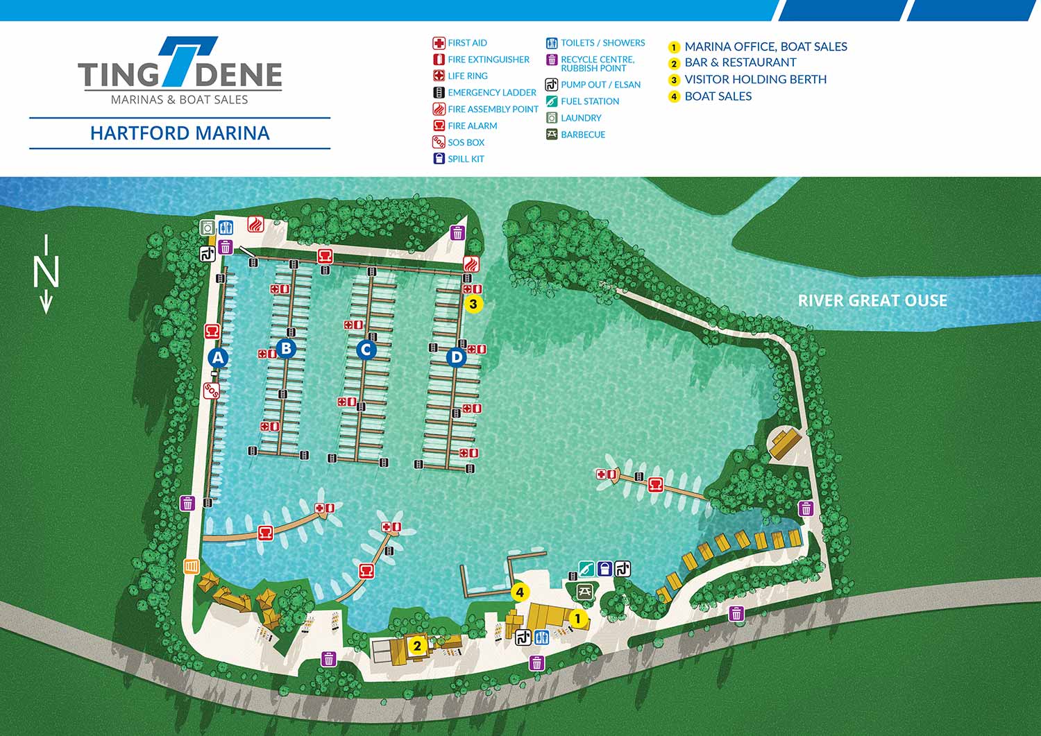
Hartford Marina is a well equipped full service marina set in the Huntingdonshire countryside, offering a peaceful waterside environment with excellent transport connections. With direct access to the River Great Ouse, the marina provides convenient cruising routes to Cambridge, Peterborough, and onward toward London. Its location and facilities make it a popular choice for both residential moorings and visiting boaters seeking a dependable and welcoming base.
The marina offers more than two hundred fixed and floating moorings suitable for river and canal boats of varying sizes. A wide range of on site amenities supports comfortable day to day berthing, while the layout is designed to make movement through the marina clear and straightforward. Hartford Marina places a strong emphasis on ease of use, safety, and high standards of service.
This project includes a detailed illustrated overhead map developed from a digital three dimensional model of the marina. The illustration style is intentionally restrained, ensuring the map remains clear and easy to navigate while still providing an engaging visual overview. Key locations are identified with numbered yellow reference points, while amenities are shown using simple, recognisable icons. Safety features such as life rings and fire extinguishers are also clearly marked, allowing the map to function as both a practical reference and a visitor friendly guide.
The map has been designed to support marina operations as well as marketing and communications. Plans include producing a durable metal display that allows magnetic labels to be placed over individual berths to indicate their current status, creating a flexible and effective marina management tool. At the same time, the illustrated map presents Hartford Marina in a professional and approachable way, making it well suited for signage, visitor information, and promotional use.
If you need a similar map please contact me.


WORK FOR TINGDENE - COMBINED MARINA AND RESIDENTIAL PARK MAPS:


TINGDENE MARINAS
Tingdene Marinas provides access to some of the most desirable cruising rivers and inland waterways throughout the United Kingdom. Their locations offer high quality facilities, welcoming waterfront bars and restaurants, well equipped boatyards, and knowledgeable marina staff. From narrowboats and barges to riverboats and cruisers, Tingdene Marinas delivers a distinctive boating experience across the UK. Custom illustrated maps like this one help communicate that experience clearly while supporting both customer engagement and operational needs.
The illustrated overhead maps I create for Tingdene Marinas are a practical tool for sales, marketing, and day to day marina management. Designed for clarity and ease of use, the maps present the marina layout in a straightforward overhead view that helps staff, boat owners, and visitors quickly understand slip locations, access routes, amenities, and service areas. Maps like this are commonly used across websites, printed materials, on site signage, and internal management systems, making them a versatile asset for marina operations.
TINGDENE RESIDENTIAL PARKS
Tingdene Residential Parks offer modern, well planned living environments designed exclusively for people over 45 who are seeking a relaxed and comfortable lifestyle. With locations throughout the United Kingdom, their parks are set in a range of attractive coastal, rural, and semi rural settings. Custom illustrated maps like this one help communicate the character and organization of each park while reinforcing Tingdene’s commitment to quality and thoughtful design.
The illustrated overhead maps I create for Tingdene Residential Parks support sales, marketing, and day to day site management. The maps present the park layouts in a clear and accessible overhead view, making it easy for prospective residents, staff, and visitors to understand plot locations, internal roads, green spaces, and shared amenities. Maps like this are commonly used across websites, printed brochures, on site signage, and internal planning tools, making them a flexible resource for both promotion and operations.
PORTFOLIOS
- Illustration Portfolio: Start here for custom illustration and book covers. You can also browse illustrated maps and architectural rendering.
- Fine Art: I offer original paintings and drawings, including my Custom Halftone Series. You will also find mural work here.
- Graphic Design & Motion: View my graphic design portfolio. After that, explore motion design and animated illustrations.
- Maps by application: I create illustrated maps for boat shows, resorts, marinas, real estate, transportation, transit and parking, towns and cities, parks, and wayfinding.
- Additional project types: I also produce cover illustration, vehicle and vinyl wraps, proposal renderings, and street art.
- Illustration methods: My techniques include vector, isometric and axonometric, painting, black and white, GeoData maps, overhead maps, and custom halftones.
- Software portfolios: I work primarily in Adobe Photoshop, Adobe Illustrator, SketchUp Pro, and Adobe InDesign. For motion projects, I use Premiere Pro and After Effects.