Transportation and Parking Map for the Palm Beach International Boat Show - 2026
Client: Informa Markets
For event information and to make sure you're seeing the latest map please visit the official site of the boat show.
An Update, Not a Redesign
This year's transportation map is an update rather than a complete redesign. The map has been practical, effective, and attractive over several years, so there was no need to start over. My focus instead was on refining what already works and incorporating the client's requested improvements.
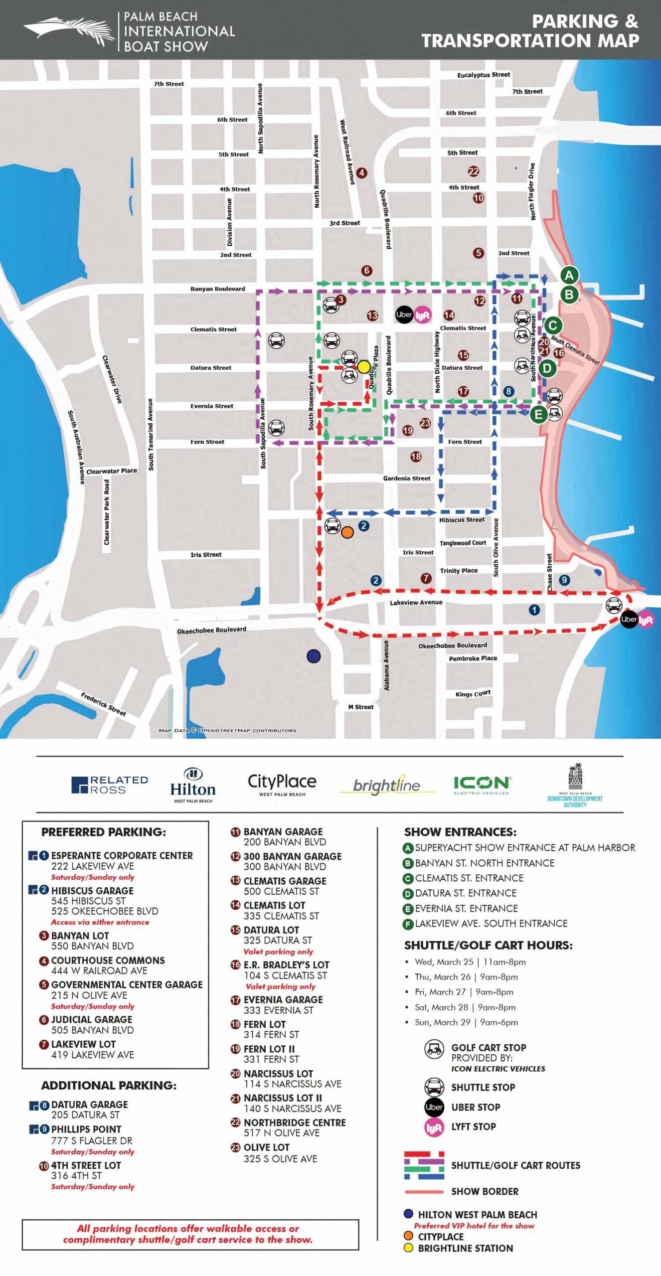
The map helps visitors navigate parking, shuttle routes, and key points of interest efficiently. It highlights main entrances to the show, preferred and additional parking areas, and shuttle stops. Parking locations are identified with numbered, color coded dots that include street addresses for easy GPS navigation.
Key local destinations like City Place are marked with colored dots for reference. Shuttle and transportation routes appear as dashed lines with arrows to show direction clearly. Four alternative local transportation options are represented with intuitive icons.
Changes for 2026
This year the client requested a different sort order for the parking key. Preferred parking now comes first in its own subgroup, followed by additional parking. Within each category, locations are listed alphabetically. All parking areas have either walkable access to the show or complimentary dedicated transportation, and that is now indicated directly on the map.
Golf cart and shuttle stop icons were changed to black and white to match the primary show map. The map also underwent the usual stop revisions, and all numbering was updated to align with the revised map key.
Some late revisions included the addition of multiple routes following complex patterns. There are actually four relatively simple loops despite the labyrinthian feel one gets at first glance. Once you isolate your needs to a single route it all becomes relatively straightforward.
The process involved multiple rounds of refinement. Clients supply revisions along the way, and this year I saved over eighteen versions of this specific map before we reached final approval. That level of iteration reflects the attention to detail we all bring to the project.
How This Map Is Different
Unlike my more artistic illustrated maps, this one overlays precise information on an overhead street layout where accuracy of scale and position is critical. The base data comes from OpenStreetMap, an open source geodata resource. I refine it by removing unnecessary roads that would contribute to visual clutter. The result shows only the essential streets, parking areas, and transit routes, making the map clear and easy to follow.
Since its initial development in 2018, this map has been refined each year to reflect route changes and improve usability. It has become a reliable tool for both visitors and show organizers.
Best Used Before You Arrive
This transit map is most valuable when accessed online or on a mobile device before heading to the show. It lets guests plan their route, identify parking options, and choose the most convenient transportation in advance. By combining precision with clarity, the map helps ensure a smooth and stress free experience for everyone attending.
Your Transportation Map
If you need a transportation or parking map for an event, a venue, or any location where accurate navigation matters, contact me. I have done this work before and I would be glad to do it for you.
Maps For Palm Beach International Boat Show:
- About The Palm Beach Boat Show
- Main Map: 2026 | 2025 | 2024 | 2023 | 2022 | 2021 | 2020 | 2019 | 2018 | 2017 | 2016 | 2015 | 2014 | 2013| 2012 | 2011
- Transit & Parking Map: 2026 | 2025 | 2024 | 2023 | 2022 | 2020 | 2019 | 2018 | 2016
- Program Layout: 2026 | 2025 | 2024
- Video: 2013
EXPLORE MY PORTFOLIOS
- Illustration: Find custom illustration, book covers, illustrated maps, and architectural rendering.
- Fine Art: Browse original paintings and drawings, the Custom Halftone Series, and murals.
- Graphic Design & Motion: See my graphic design work, plus motion design and animated illustrations.
- Maps by industry: Illustrated maps tailored for boat shows, resorts, marinas, real estate, transit & parking, towns & cities, parks, and wayfinding.
- Other project types: Also available: cover art, vehicle & vinyl wraps, proposal renderings, and street art.
- Techniques: Explore work in vector, isometric & axonometric, painting, black & white, GeoData, overhead, and halftone styles.
- Software: Primary tools: Photoshop, Illustrator, SketchUp Pro, and InDesign. Motion work uses Premiere Pro & After Effects.