
Map for the Palm Beach International Boat Show - 2019
For event information and all the latest maps please visit the official site of the boat show. If you are interested in purchasing usage rights to this map or hiring me to create an original map or illustration for you please contact me.
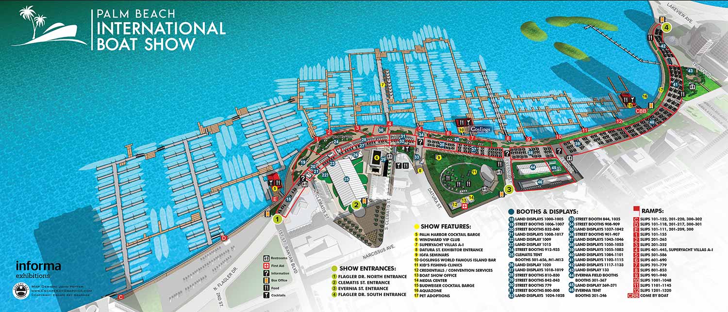


The 2019 Palm Beach International Boat Show map required only minor revisions from the previous year, a strong indication of an effective and well established design. This consistency is beneficial, as returning guests appreciate the familiar and proven layout when navigating the event.
My process for creating these maps is collaborative and detail oriented. The client generally provides me with CAD drawings of the proposed show layout. I carefully review these drawings to identify any inconsistencies. Based on this analysis, I update the positions of floating docks, boat silhouettes, and exhibitor tents on the three dimensional digital model that serves as my master file. The client then reviews this initial revised map, pointing out any details I may have overlooked or areas requiring clarification.
This review is typically followed by updated information for the map keys, provided in a text format, which often leads to further revisions. The dynamic nature of the industry means last minute changes are common, with new exhibitors signing up and sponsors making adjustments close to the event date. Many of my clients include disclaimers on their materials noting that information is subject to change after printing or posting. This fluid environment is one reason many illustrators might avoid such projects. Successfully creating boat show maps requires a graphic artist who is not only accurate but also fast and highly adaptable.
The 2019 map was deployed across multiple platforms. It was featured on the official website, integrated into the mobile application, adapted into a vertical format for onsite signage, and printed as a folding handout map. My work for this show also included designing and illustrating maps for show transportation and creating detailed layouts for three major exhibitor tents.
Illustrated event maps serve a unique purpose by allowing potential visitors to visualize the future experience. Instead of relying on generic stock photos, guests can see a clear representation of the event layout. These maps effectively communicate the scale and venue of the event while providing practical information about amenities such as restroom locations, food access, and transportation and parking options. As a result, illustrated maps function as both visually pleasing graphics and genuinely informative marketing materials.
For more examples of my event cartography, please visit my Maps Portfolio.
Maps For Palm Beach International Boat Show:
- About The Palm Beach Boat Show
- Main Map: 2026 | 2025 | 2024 | 2023 | 2022 | 2021 | 2020 | 2019 | 2018 | 2017 | 2016 | 2015 | 2014 | 2013| 2012 | 2011
- Transit & Parking Map: 2026 | 2025 | 2024 | 2023 | 2022 | 2020 | 2019 | 2018 | 2016
- Program Layout: 2026 | 2025 | 2024
- Video: 2013


PORTFOLIO SELECTIONS
- Custom illustration & covers: Featuring bespoke illustration, book and magazine covers, hand-drawn maps, and building renderings.
- Fine art & murals: Including one-of-a-kind paintings and drawings, the Custom Halftone Series, and large-scale murals.
- Design & motion media: Covering graphic design, plus video and motion and animated illustration.
- Mapping by application: Tailored maps for marine events, hospitality, waterfront, property, transit, municipal, recreation, and navigation needs.
- Additional creative work: Includes editorial covers, vehicle graphics, concept renderings, and public art.
- Mediums & formats: Ranging from digital vector and isometric projection to traditional paint, line art, GIS-based, aerial-style, and halftone.
- Software expertise: Proficient in Photoshop, Illustrator, SketchUp, InDesign, and Premiere/After Effects for motion.