Illustrated map showing where to find public art
Client: Visit Minot
For information about the Minot, ND and the latest map version see VisitMinot.org
From KX News At 4
Finding the Art in Minot
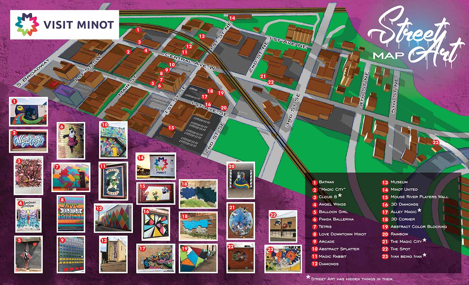
The street art movement has been spreading across the country, and Minot, North Dakota is right in the middle of it. Visit Minot recently published a street art map to help locals and visitors find every mural in the city. The map shows exactly where each piece is located, with numbers that match a list of names and pictures. When the project started, there were 16 murals to find. The map was designed from the beginning to grow as the art scene grew.
The 2020 Update
The version you see here is an update I created in 2020. The original map was made in 2019. By 2020, the number of keyed street art pieces had grown from 18 to 23. More importantly, the geographic area covered by the map expanded by about 80 percent. Minot's art scene was moving into new territory, and the map had to move with it.
I built this update on the same three dimensional digital model I had created for the 2019 map. That made the whole process smooth and efficient. I did not have to start over. I just added the new pieces and extended the boundaries.
Why That Matters
The ease of this update is testimony to a process that is built to last. I design my maps using reusable, expandable assets that can be revised without rebuilding everything from scratch. It also comes down to good file management. I keep digital files from old projects in intuitive directory structures. I can go back years later and pick up where I left off without major hassles. This came up recently on a project over ten years old. The client was surprised to find that I still had the files, knew exactly where they were, and could begin work on revisions immediately. That is not just about reducing my own labor. It is about reducing turnaround time for clients who need updates fast.
What the Client Says
"We're excited to see what people do when they go downtown and the pictures that they share," said Rianne Kuhn, director of marketing and communications for Visit Minot. "You can check it out on Instagram and we actually regram or repost some of those things as well just because the user generated content is so unique."
Your Project
If you need a map for your city, your art district, or any other area that needs clear, engaging visual navigation, contact me. I have done this work before and I would be glad to do it for you.
(and maps of similar areas)


EXPLORE MY WORK
- Illustration: Discover custom illustrations, book covers, illustrated maps, and architectural renderings.
- Fine Art: Browse original paintings and drawings, view the Custom Halftone Series, or check out mural projects.
- Graphic Design & Motion: See the graphic design collection, then dive into motion design and animated illustrations.
- Maps by industry: View illustrated maps tailored for boat shows, resorts, marinas, real estate, transportation, towns, parks, and wayfinding.
- More project types: Explore cover art, vehicle wraps, proposal renderings, and street art.
- Techniques & styles: Work spans vector, isometric, painting, black-and-white, GeoData, overhead maps, and halftones.
- Software expertise: Primary tools include Photoshop, Illustrator, SketchUp Pro, and InDesign, plus Premiere Pro & After Effects for motion.