An overhead map of a marina on the island of Bimini, The Bahamas
Project Management by Stephen Kappeler - Bimini Big Game Club Resort and Marina
Thanks to my sister, Dianna, for helping take slip measurements in Bimini
I created this map. For more (and the latest) information about Bimini Big Game Club Resort & Marina please visit their site BigGameClubBimini.com.
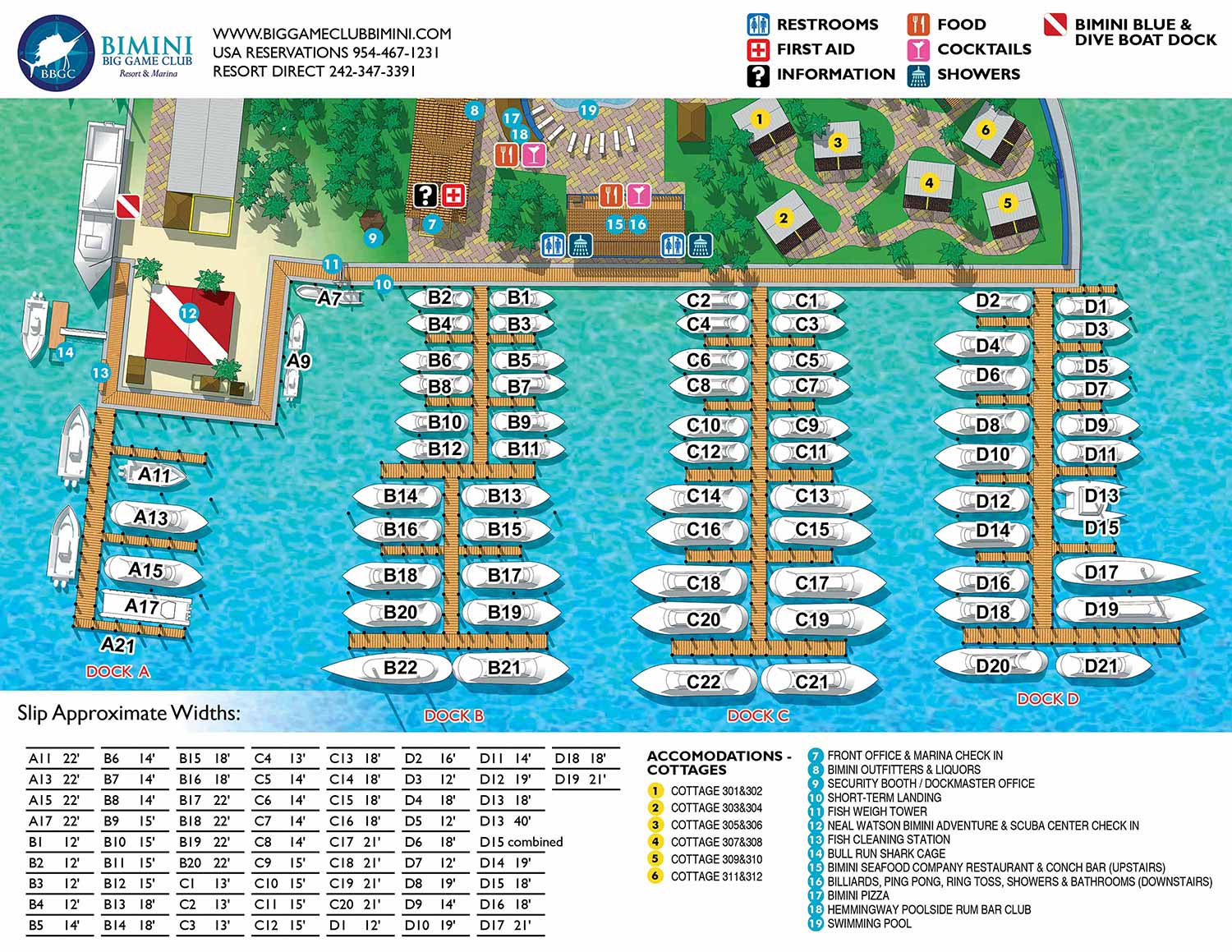
I created this second illustrated map for Bimini Big Game Club Resort and Marina specifically to support marina operations and day-to-day management. Unlike the guest oriented resort map, this version was designed as a straight overhead view, prioritizing clarity, accuracy, and ease of use. The focus of the map is functional, allowing marina staff and boaters to quickly understand the layout of docks, fairways, and slips.
This map emphasizes slip identification and spatial organization, with clearly labeled dock names and slip numbers arranged in a clean, logical format. While the illustration maintains a polished and visually appealing style, unnecessary detail was intentionally reduced to avoid distractions. The overhead perspective ensures that distances, orientations, and relationships between slips and docks are immediately legible, which is essential for vessel assignment, communication, and operational efficiency.
Although designed for management purposes, the map still reflects the overall character of the marina through careful color choices and consistent graphic styling. The result is a practical working map that supports marina staff, captains, and guests alike, while also serving as a professional visual asset that aligns with the broader branding of Bimini Big Game Club Resort and Marina. This map will ultimately be used as signage and as a general tool to help organize the marina.
Also related: Overview Map | Marina Slip Map


Additional Portfolios:
- Augmented Reality Portfolio
- Racing Related Portfolio
- Medical Illustrations Portfolio
- Character Illustration Portfolio
- Portrait Portfolio
PORTFOLIO GALLERIES
- Illustration work: Start with custom illustration and cover design, then view illustrated maps and architectural renderings.
- Fine art: Discover original paintings and drawings, the Custom Halftone Series, and mural projects.
- Design & motion: Check out the graphic design gallery, then move on to motion graphics and animated illustration.
- Maps by sector: I produce illustrated maps for boat shows, resorts, marinas, real estate, transit & parking, towns & cities, parks, and wayfinding systems.
- More creative services: Additional offerings include cover illustration, vehicle wraps, proposal renderings, and street art.
- Artistic methods: My work spans vector art, isometric & axonometric views, traditional painting, black & white illustration, GeoData mapping, overhead perspectives, and halftone effects.
- Preferred software: I rely on Photoshop, Illustrator, SketchUp Pro, and InDesign, plus Premiere Pro & After Effects for motion projects.