Marinas Illustrated Maps Portfolio
Born from Boat Shows, Built for Marinas
My marina map work started as part of larger boat show projects. Over time, those assignments grew into a dedicated focus of my studio. Today, marinas across the United States, the Caribbean, and the United Kingdom use illustrated maps I created for them. Every map balances visual appeal with practical problem solving. The goal is to communicate clearly and present each waterfront in a professional, inviting way.
Maps That Earn Their Keep
Marina maps rarely sit idle. Guests use them to find parking, restrooms, fuel docks, and restaurants. Staff depend on them for daily operations and slip assignments. Marketing teams distribute printed versions and feature them on websites. Some maps are enlarged into dockside signage. Others are built for mobile screens. Accuracy and ease of use matter in every format and for every audience.
Two Paths, One Standard
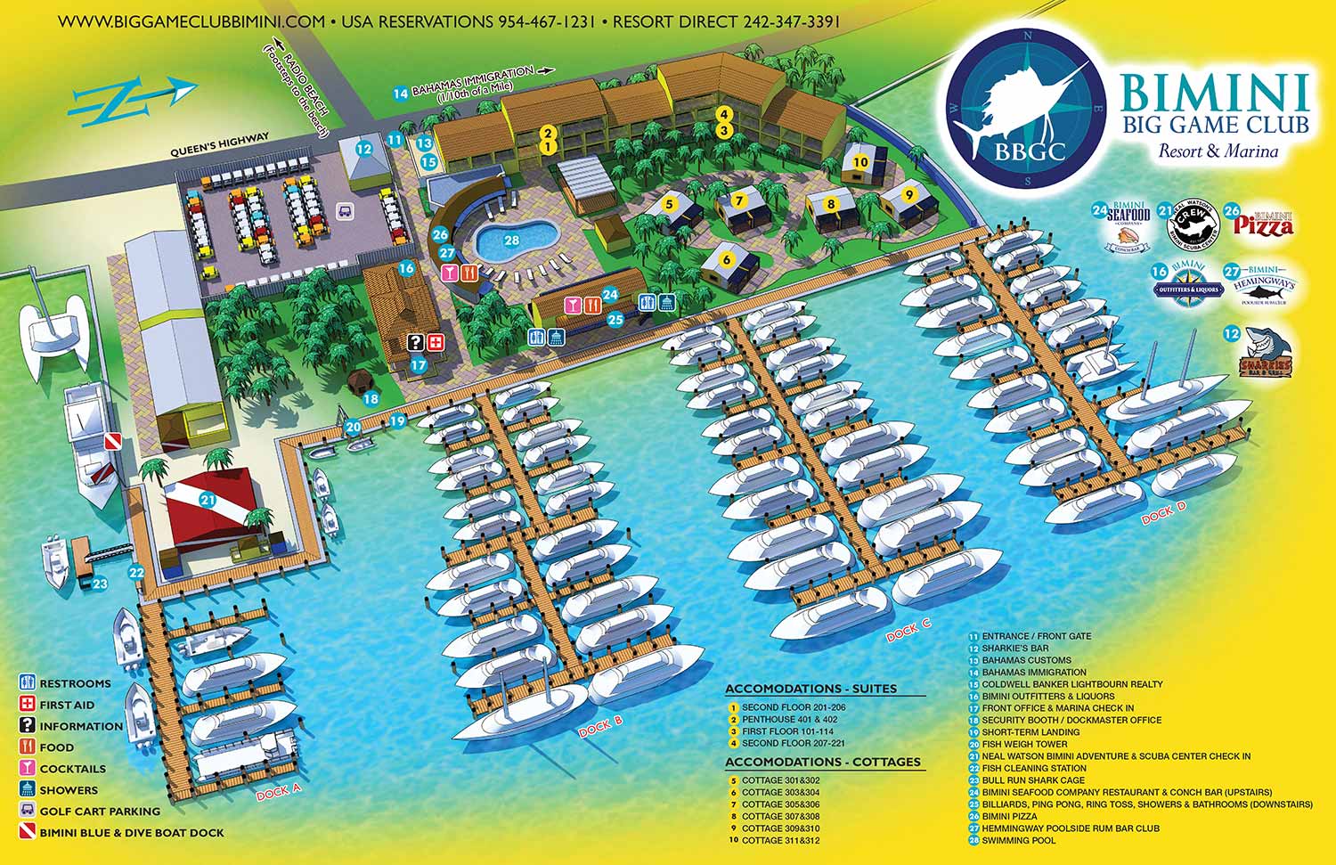
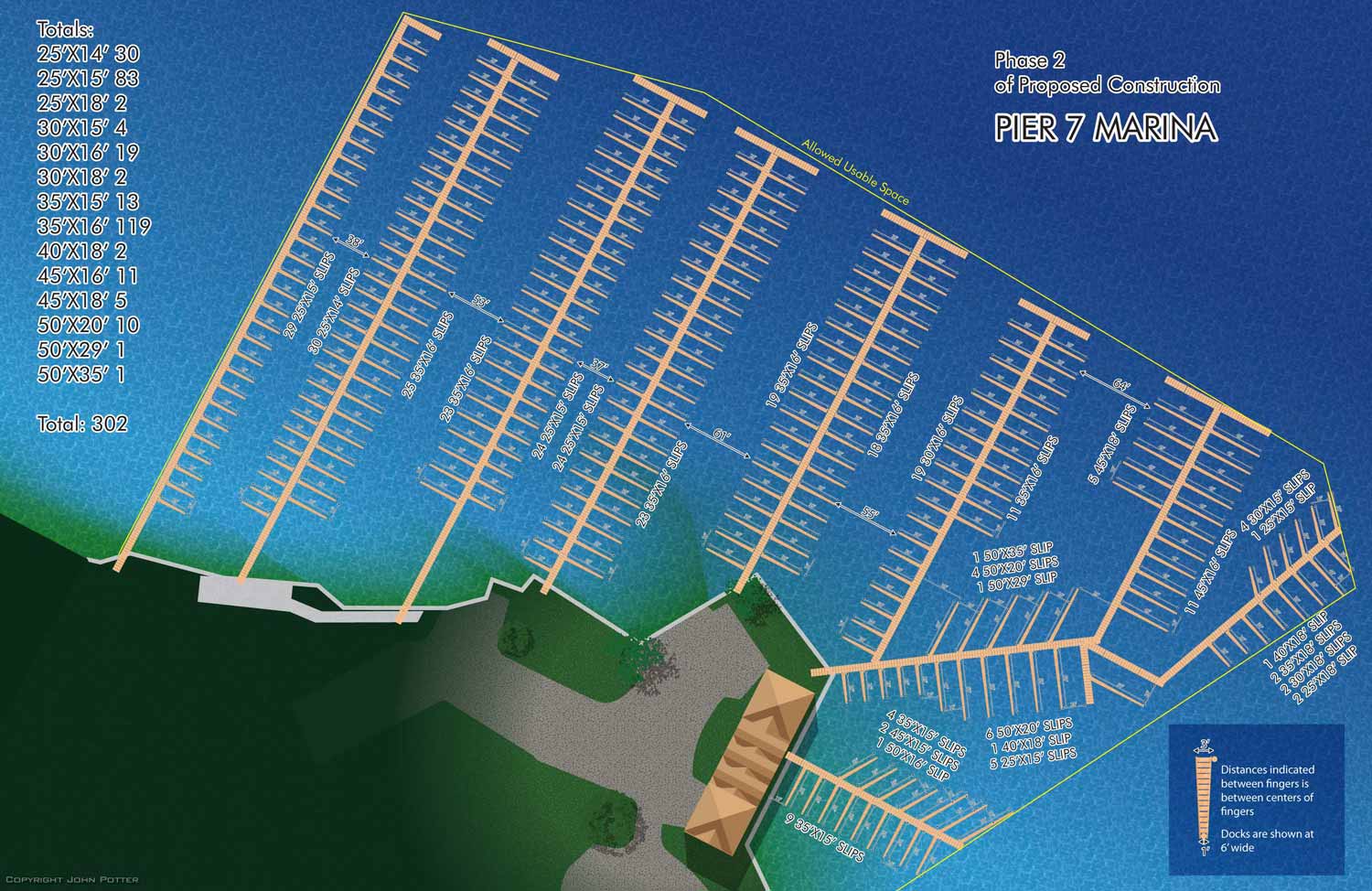
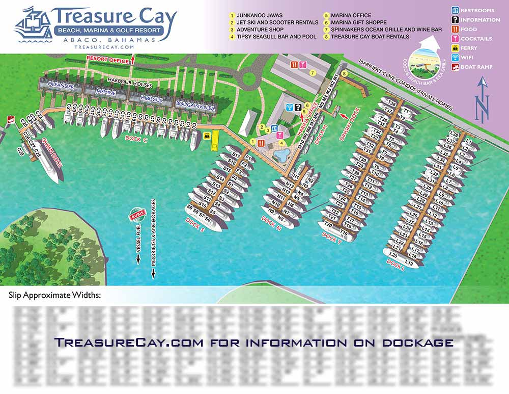
Most marina projects follow one of two directions. The first is an illustrative map built for guests. These maps highlight amenities, services, and general dockage areas while reinforcing brand identity. The second is a slip or berth map presented as a clean overhead view. These emphasize precision and efficiency. Staff use them as management tools, often enlarged for reference boards or posted at key points around the property.
Experience at the Water's Edge
More marinas now blend traditional dockage with resort amenities and mixed use development. Working with a designer who understands both marine operations and guest orientation makes a real difference. My background includes years of map making for boat shows, resorts, and transit systems. This experience allows me to deliver maps that are clear, functional, and built for the long term. Clients receive regular progress updates throughout each project. Final files are supplied in layered vector formats. The illustrated artwork remains fixed, but labels, keys, and graphic elements stay fully editable. This setup allows for simple in house updates without compromising the original illustration.
What Marina Clients Say
Toni Norman at Tingdene Marinas said I quickly grasp project requirements and deliver efficient, high quality work. Stephen Kappeler from Bimini Big Game Club found me at a boat show and noted my keen sense of detail and understanding of how graphics represent a business. Brent Ingraham at Abaco Beach Resort described his map as an excellent and incredible work of art. These projects began as conversations and resulted in maps that serve both guests and staff every day.
Ready to Map Your Marina
If you manage a marina, yacht club, or mixed use waterfront property, I am ready to discuss your project. Contact me through Escape Key Graphics to request a quote or begin a conversation about your specific needs.
MARINA MAPS:


TINGDENE MARINA MAPS:


I am currently accepting new commissions for . Tell me about your resort, marina, or event and I will let you know how I can help. Contact me.
PORTFOLIOS
- Illustration Portfolio: Start here for custom illustration and book covers. You can also browse illustrated maps and architectural rendering.
- Fine Art: I offer original paintings and drawings, including my Custom Halftone Series. You will also find mural work here.
- Graphic Design & Motion: View my graphic design portfolio. After that, explore motion design and animated illustrations.
- Maps by application: I create illustrated maps for boat shows, resorts, marinas, real estate, transportation, transit and parking, towns and cities, parks, and wayfinding.
- Additional project types: I also produce cover illustration, vehicle and vinyl wraps, proposal renderings, and street art.
- Illustration methods: My techniques include vector, isometric and axonometric, painting, black and white, GeoData maps, overhead maps, and custom halftones.
- Software portfolios: I work primarily in Adobe Photoshop, Adobe Illustrator, SketchUp Pro, and Adobe InDesign. For motion projects, I use Premiere Pro and After Effects.