Boat Show and Event Map Portfolio


Setting the Standard Since 2011
I created my first boat show map in 2011. Others had illustrated marine events before me, but my work has helped shape what the industry now expects from a professional show map. Accuracy, clarity, and visual appeal have to work together. Over many seasons and many shows, I have refined that balance until it became a repeatable standard. Today, that standard guides maps for the largest boat shows in the country.
Maps That Do Heavy Lifting
Boat shows are not simple venues. They sprawl across convention halls, marinas, parks, and waterfront streets. Exhibitors need to find their booth. Attendees need to locate seminars, restrooms, food, and their cars. Organizers need everyone moving efficiently. A well built map serves all of them at once. My maps reduce confusion, support traffic flow, and reinforce the event brand. First time visitors find their way. Seasoned attendees move with confidence.
Built from the Ground Up
Every show has a different footprint. My process starts with research and close coordination with event organizers. I need to understand booth arrangements, entry points, hospitality zones, and the features that matter most to participants. From that foundation I build a map that blends accurate spatial information with clear illustration. Clients see regular progress updates at every stage. There are no surprises at delivery.
One Map, Many Formats
These maps are designed to move across media. Printed programs, wayfinding signage, mobile screens, and downloadable PDFs all receive the same attention to clarity. A map that works at tabletop size must also function at twenty feet wide. I account for those differences during the design phase, not after. Whether the show is based at a convention center, stretched along a waterfront, or split across multiple venues, the goal is consistent. Visitors should understand the layout in seconds.
More Than Navigation
A map that only points the way is leaving value on the table. These illustrations also serve as strategic marketing assets months before the show opens. Event marketing often relies on stock photography and bold but empty graphics. An illustrated map provides real information about scale, layout, and venue character. Potential attendees, sponsors, and partners receive a credible preview that builds anticipation and aids planning. It is a tool for promotion as much as for navigation.
Intuitive by Design
Illustrated maps communicate differently than diagram drawings. The rendering style makes immediate visual sense of land and water, hardscape and open space, building and dock. Users who prefer traditional diagrams find everything they need. Others discover a level of accessibility they did not expect. Both groups navigate with less effort and fewer questions.
Current Show Roster
I am presently responsible for illustrated maps at the Chicago International Boat Show, Fort Lauderdale International Boat Show, Miami International Boat Show, Newport International Boat Show, Newport Beach International Boat Show, San Diego International Boat Show, Palm Beach International Boat Show, Suncoast Boat Show, and Saint Petersburg Power and Sailboat Show. This directory continues to grow each season.
Ready to Map Your Event
If you manage a boat show, festival, or large scale public event, I am ready to discuss your mapping needs. Contact me through Escape Key Graphics to request a quote or begin a conversation about your specific venue and audience.


By Show:
MAPS FOR BOAT SHOWS IN FORT LAUDERDALE:


Fort Lauderdale International Boat Show Maps:
- About Fort Lauderdale International Boat Show
- Bahia Mar, Swimming Hall of Fame & Las Olas Marina Maps: 2025 | 2024 | 2023 | 2022 | 2020 | 2019 | 2018 | 2017 | 2016 | 2015 | 2014 | 2013 | 2012 | 2011 | 2010
- Parking and Transportation Maps: 2025 | 2024 | 2023 | 2022 | 2020 | 2019 | 2018 | 2015 Bus | 2015 Water Taxi | 2014 | 2013 | 2012 | 2011
- Broward County Convention Center Maps: 2025 | 2024 | 2023 | 2022 | 2017 Sailfish Pavilion | 2017 | 2016 Sailfish Pavilion | 2016 | 2015 Sailfish Pavilion | 2015 | 2014 Sailfish Pavilion | 2014 | 2013 Sailfish Pavilion | 2013 | 2012 | 2011 | 2010
- Marinas Maps: 2025 | 2024 | 2023 | 2022 | 2019 | 2016
- Program Layouts: 2025 | 2024 | 2023 | 2022
- Signs: 2013 looking north | 2013 Yachting Tent
- Video: 2013 54th Annual
- Illustrations (not maps): 2014A | 2014B
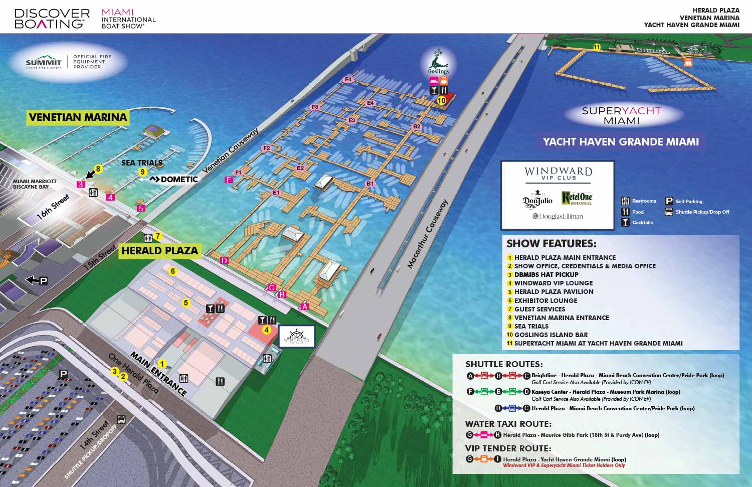
EXAMPLES OF MAPS CREATED FOR MIAMI BOAT SHOWS:


Maps For Boat Shows In Miami:
- About Miami Boat Shows
- Miami International Boat Show / Miami Yacht Show / Yachts Miami Beach / Miami Beach Yacht and Brokerage Show - Show Center/Primary Venue Maps: 2026 | 2025 | 2024 | 2023 | 2022 | 2020 | 2019 | 2018 | 2017 | 2016 | 2015 | 2014 | 2013 | 2012 | 2011
- Transportation Map: 2026 | 2025 | 2024 | 2023 | 2022 | 2020 | 2019 | 2016 | 2013 | 2012
- Program Layout: 2026 | 2025 | 2024 | 2023 | 2022
- Yacht Haven Grande at Island Gardens: 2026 | 2022 | 2020 | 2016
- Miami Beach Convention Center: 2026 | 2025 | 2024 | 2023 | 2022 | 2013 | 2012
- Sea Isle Marina Only: 2013 | 2012
- Miamarina at Bayside Only: 2013 | 2012 | 2011
- Bayfront Park: 2015
- Museum Park Marina: 2025 | 2024 | 2023 | 2022
- Illustration (not a map): 2014
- Video: 2013
MAPS FOR THE PALM BEACH INTERNATIONAL BOAT SHOW:
Maps For Palm Beach International Boat Show:
- About The Palm Beach Boat Show
- Main Map: 2026 | 2025 | 2024 | 2023 | 2022 | 2021 | 2020 | 2019 | 2018 | 2017 | 2016 | 2015 | 2014 | 2013| 2012 | 2011
- Transit & Parking Map: 2026 | 2025 | 2024 | 2023 | 2022 | 2020 | 2019 | 2018 | 2016
- Program Layout: 2026 | 2025 | 2024
- Video: 2013
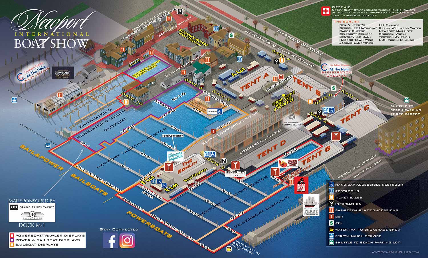
MAPS FOR THE NEWPORT INTERNATIONAL BOAT SHOW:


Maps For Newport International Boat Show:
- About Newport International Boat Show
- Main Map: 2025 | 2024 | 2023 | 2022 | 2021 | 2019 | 2018 | 2017 | 2016 | 2015 | 2014 | 2013 | 2012
- Tent Details Map: 2017 | 2016 | 2015 | 2014 | 2013 | 2012
- Video: 2012
MAPS FOR THE SAINT PETERSBURG POWER AND SAILBOAT SHOW:
St. Petersburg Power & Sailboat Show Maps
- About St. Petersburg Power & Sailboat Show
- 2026 | 2025 | 2024 | 2023 | 2022 | 2021 | 2019 | 2018 | 2017 | 2016 | 2015 | 2014 | 2013 | 2012 | 2011
MAPS FOR BOAT SHOWS IN CHICAGO:
Maps For The Chicago International Boat:
- About Chicago International Boat Show
- Chicago International Boat Show: 2025
Maps For The Windy City Boat & Yacht Show:
- About The Windy City Boat & Yacht Show
- The Windy City Boat & Yacht Show: 2026
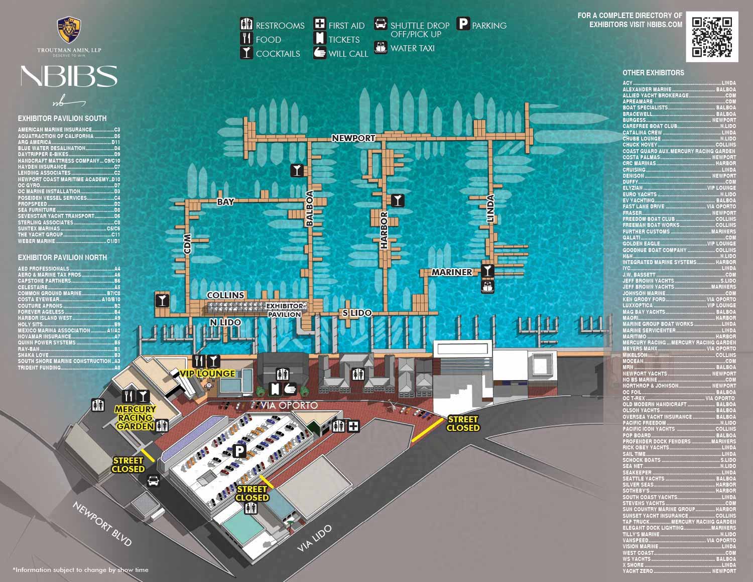
MAP FOR THE NEWPORT BEACH INTERNATIONAL BOAT SHOW:
MAPS FOR THE NEWPORT BEACH INTERNATIONAL BOAT SHOW:
MAP FOR THE SAN DIEGO INTERNATIONAL BOAT SHOW:
MAPS FOR THE SAN DIEGO INTERNATIONAL BOAT SHOW:
MAPS FOR THE PANAMA INTERNATIONAL BOAT SHOW:
Panama International Boat Show Map
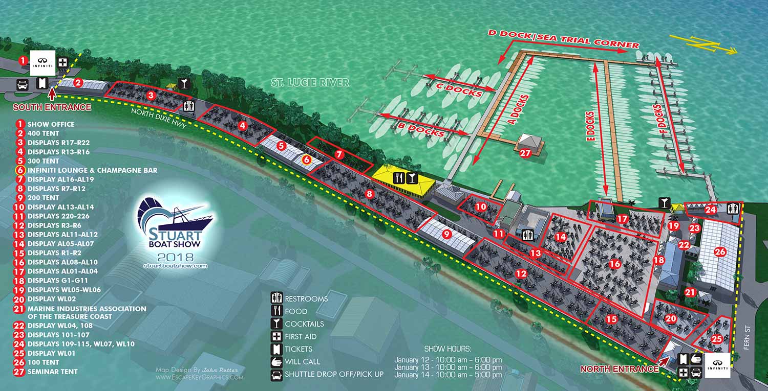
MAP FOR THE STUART BOAT SHOW:
Stuart Boat Show Map
I am currently accepting new commissions for . Tell me about your resort, marina, or event and I will let you know how I can help. Contact me.
BROWSE MY WORK
- Illustration: Browse custom illustrations, book cover art, illustrated maps, and architectural renderings.
- Fine art: View original paintings and drawings, the Custom Halftone Series, and mural commissions.
- Graphic design & motion: See design projects, then watch motion reels and animated pieces.
- Maps by use case: Explore illustrated maps created for boat shows, resorts, marinas, real estate, transportation & parking, cities & towns, parks, and wayfinding.
- Specialty projects: Also check out cover design, vinyl & vehicle wraps, proposal renderings, and street art.
- Style & technique: Discover vector, isometric, painterly, monochrome, data-driven, bird's-eye, and halftone approaches.
- Tools I use: Everyday software includes Photoshop, Illustrator, SketchUp, and InDesign; motion work relies on Premiere & After Effects.