A new angle on the show, built from the ground up
Client: The Newport Exhibition Group
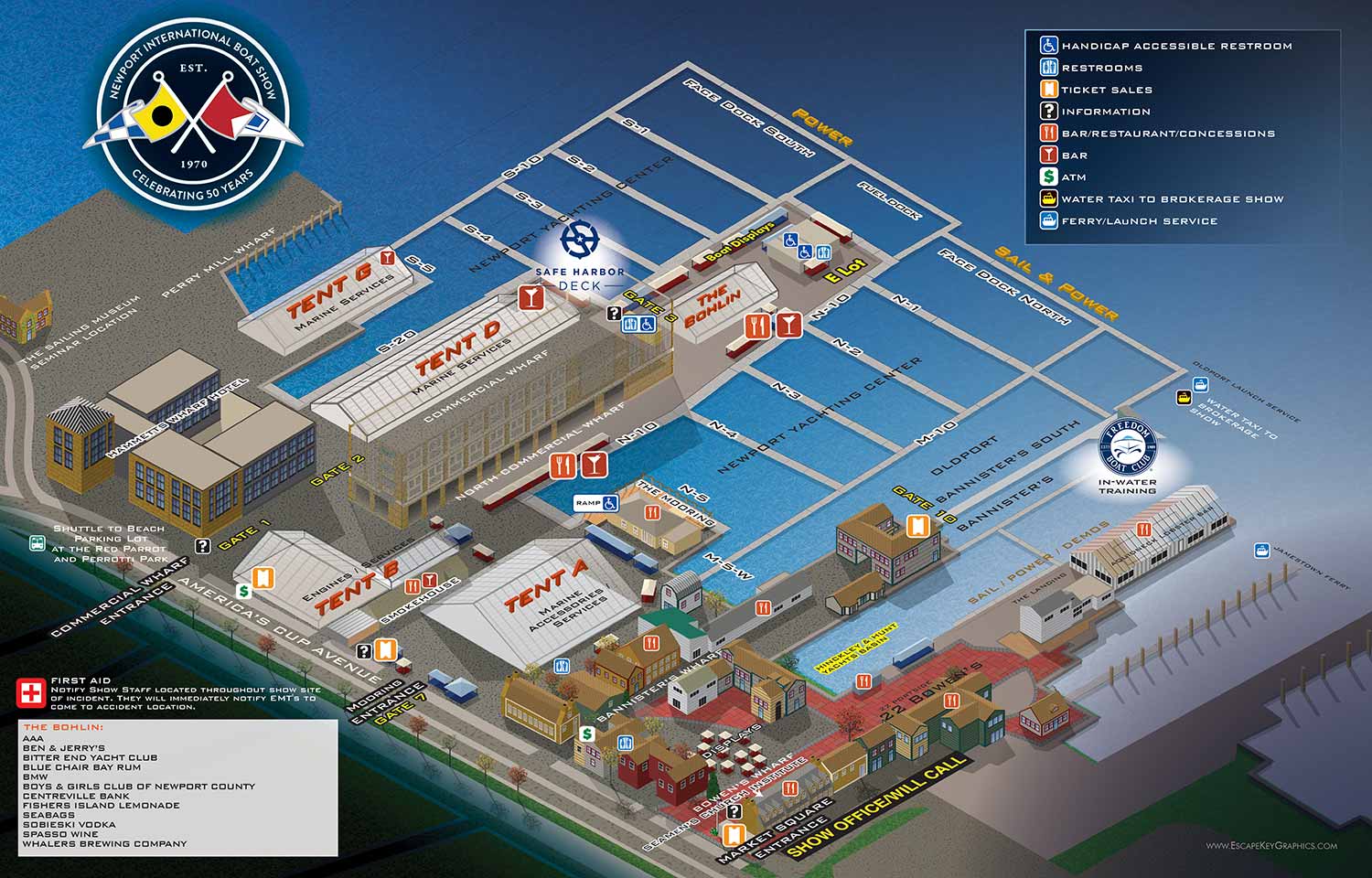
About the Show
The Newport International Boat Show is one of the largest and most respected boat shows in the Northeast. It takes place each September across more than seventeen acres in historic downtown Newport, Rhode Island. The show spreads across multiple interconnected sites including the Newport Yachting Center, Hammetts Hotel, Perry Mill Wharf, Bowen's Wharf, Bannisters Wharf, and Market Square. The venue is dense and the line between the show and the surrounding neighborhood is softer than at most other shows I work on.
I have been illustrating and designing the official map for this show since 2012.
A New Angle for 2021
For 2021, The Newport Exhibition Group wanted a new viewing angle. Previous versions of the map showed the show from offshore, looking inland. The new version would show the venue as if from land, looking out toward the water.
This approach is common in map design. Most theme park maps, for example, place the entrance at the bottom center. That is how people naturally orient themselves when they arrive. I do not always follow this rule for waterfront venues. With resorts, clients often want the shoreline front and center. But for a boat show, the land entry perspective made sense.
After the pandemic, I think a lot of my clients wanted to shake things up. They wanted a fresh start, and that often showed up in visual changes.
I did not oppose the new angle. But I did present the option of switching to the three dimensional digital model method I had begun using for other shows. The client looked at both approaches and preferred to keep the axonometric look and feel for the time being.
The Changes in 2021
The new angle required a major rebuild. I had to go back to the flat map I created in 2012 and rebuild everything from that foundation. It was essentially starting over, but with the benefit of knowing the venue well.
Beyond the angle change, I did my best to retain the colors and textures from previous versions. I wanted the map to feel fresh but still familiar.
We reduced the amount of labeling compared to earlier years. And of course all the labels, icons, and symbols had to be repositioned to work with the new view.
Beyond these visible changes, the usual work of updating floating dock and land exhibitor placements remained the bulk of the effort. The client also supplied a new logo. It was not my design, but it changed the overall look quite a bit. I liked it, even if it felt a little more like racing graphics than traditional nautical style to me.
Why a Map Matters
Maps like this are great wayfinding tools. They can be used for signage, printed handouts, phone apps, and websites. But that is not their full potential.
A well made map is also a marketing tool. It gives potential visitors actual information about your event before it happens. It lets them plan, imagine themselves there, and get excited. A map is visual information unique to your event. It connects people with your event in a way that lifestyle photography and flashy graphics cannot.
What I Can Do For You
If you have an event or anything else that needs a map, contact me. I have over a decade of experience doing this kind of work and I would be glad to help you take your event to the next level.
Maps For Newport International Boat Show:
- About Newport International Boat Show
- Main Map: 2025 | 2024 | 2023 | 2022 | 2021 | 2019 | 2018 | 2017 | 2016 | 2015 | 2014 | 2013 | 2012
- Tent Details Map: 2017 | 2016 | 2015 | 2014 | 2013 | 2012
- Video: 2012
PORTFOLIOS
- Illustration Portfolio: Start here for custom illustration and book covers. You can also browse illustrated maps and architectural rendering.
- Fine Art: I offer original paintings and drawings, including my Custom Halftone Series. You will also find mural work here.
- Graphic Design & Motion: View my graphic design portfolio. After that, explore motion design and animated illustrations.
- Maps by application: I create illustrated maps for boat shows, resorts, marinas, real estate, transportation, transit and parking, towns and cities, parks, and wayfinding.
- Additional project types: I also produce cover illustration, vehicle and vinyl wraps, proposal renderings, and street art.
- Illustration methods: My techniques include vector, isometric and axonometric, painting, black and white, GeoData maps, overhead maps, and custom halftones.
- Software portfolios: I work primarily in Adobe Photoshop, Adobe Illustrator, SketchUp Pro, and Adobe InDesign. For motion projects, I use Premiere Pro and After Effects. You can watch my demo reel here.