
Palm Beach International Boat Show Transportation and Parking Map 2022
Design by John Potter of Escape Key Graphics
Client: Informa Markets
For the latest map version visit PBBoatshow.com
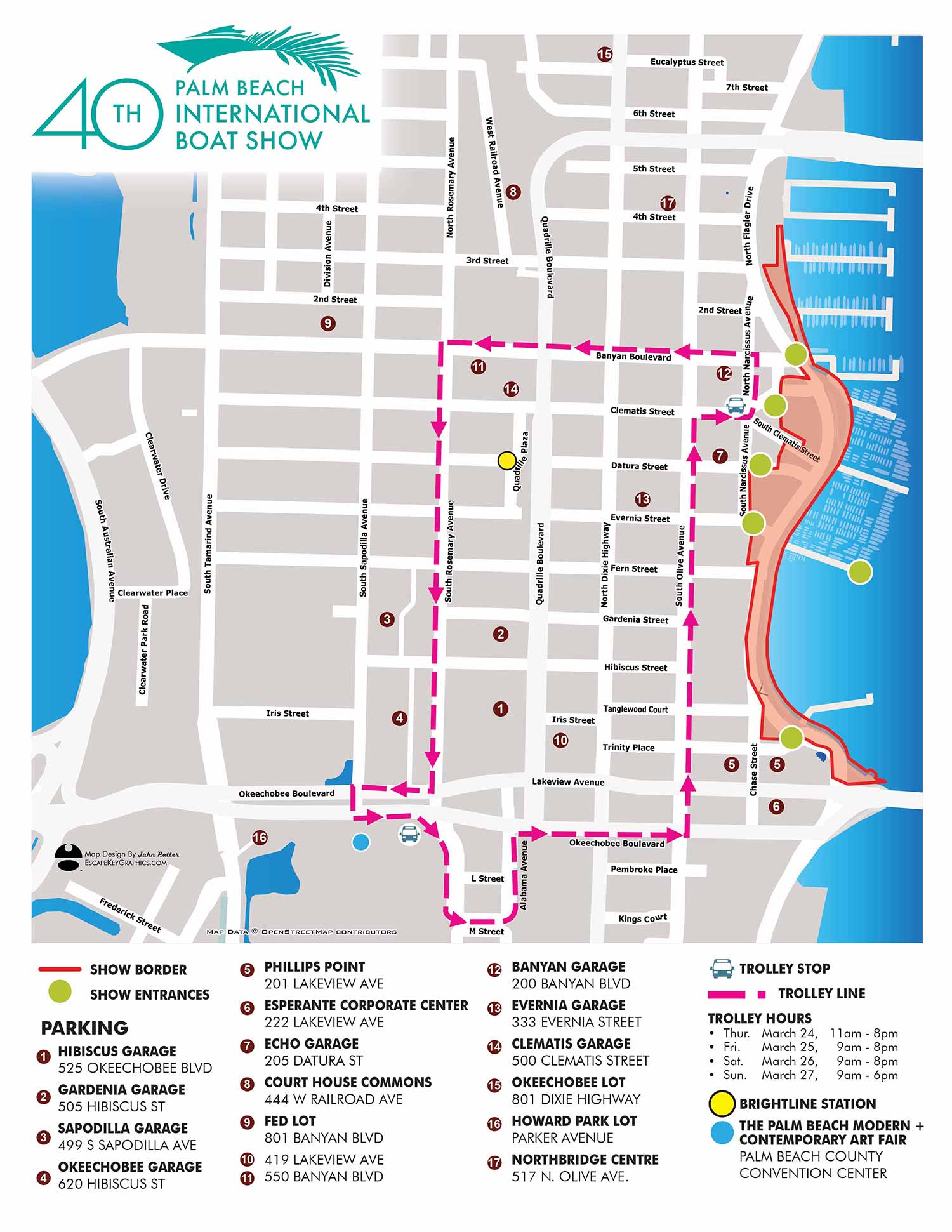
The 2022 Palm Beach International Boat Show transit and parking map represented a significant leap forward in design, prioritizing simplicity, enhanced legibility, and a more refined aesthetic. This year's version marks a substantial improvement in graphic design clarity.
A conscious decision was made to eliminate all superfluous visual clutter. The map depicts only major streets, and the land area is rendered in a pleasant, neutral taupe rather than a standard green. The trolley routes were simplified to a single continuous loop, further reducing complexity.
The map key required only minor adjustments. Information was updated, but the established system of white numerals on maroon dots was retained for identifying parking facilities, ensuring continuity for returning visitors. The map clearly keys the show border, the single trolley route, and the Brightline station. A notable change was the reduction of keyed trolley stops from twelve the previous year to just two. While this may have offered less granular detail for navigation, it greatly improved the map's overall readability and made the transportation system easier to comprehend at a glance.
I believe this map was utilized primarily online and for onsite signage at this stage. Its clean, straightforward design made it an excellent practical marketing tool when published on the event website, allowing attendees to plan their visit with ease and confidence.
For more examples of my informational maps, please visit my Maps portfolio.
Maps For Palm Beach International Boat Show:
- About The Palm Beach Boat Show
- Main Map: 2026 | 2025 | 2024 | 2023 | 2022 | 2021 | 2020 | 2019 | 2018 | 2017 | 2016 | 2015 | 2014 | 2013| 2012 | 2011
- Transit & Parking Map: 2026 | 2025 | 2024 | 2023 | 2022 | 2020 | 2019 | 2018 | 2016
- Program Layout: 2026 | 2025 | 2024
- Video: 2013
PORTFOLIO SELECTIONS
- Custom illustration & covers: Featuring bespoke illustration, book and magazine covers, hand-drawn maps, and building renderings.
- Fine art & murals: Including one-of-a-kind paintings and drawings, the Custom Halftone Series, and large-scale murals.
- Design & motion media: Covering graphic design, plus video and motion and animated illustration.
- Mapping by application: Tailored maps for marine events, hospitality, waterfront, property, transit, municipal, recreation, and navigation needs.
- Additional creative work: Includes editorial covers, vehicle graphics, concept renderings, and public art.
- Mediums & formats: Ranging from digital vector and isometric projection to traditional paint, line art, GIS-based, aerial-style, and halftone.
- Software expertise: Proficient in Photoshop, Illustrator, SketchUp, InDesign, and Premiere/After Effects for motion.