Overhead Map for the Miami Yacht Boat Show - Transportation and Parking
Graphic Design by John Potter - Escape Key Graphics
For information about the Miami Yacht Boat Show visit MiamiYachtShow.com
For information about the Miami Yacht Boat Show visit MiamiYachtShow.com
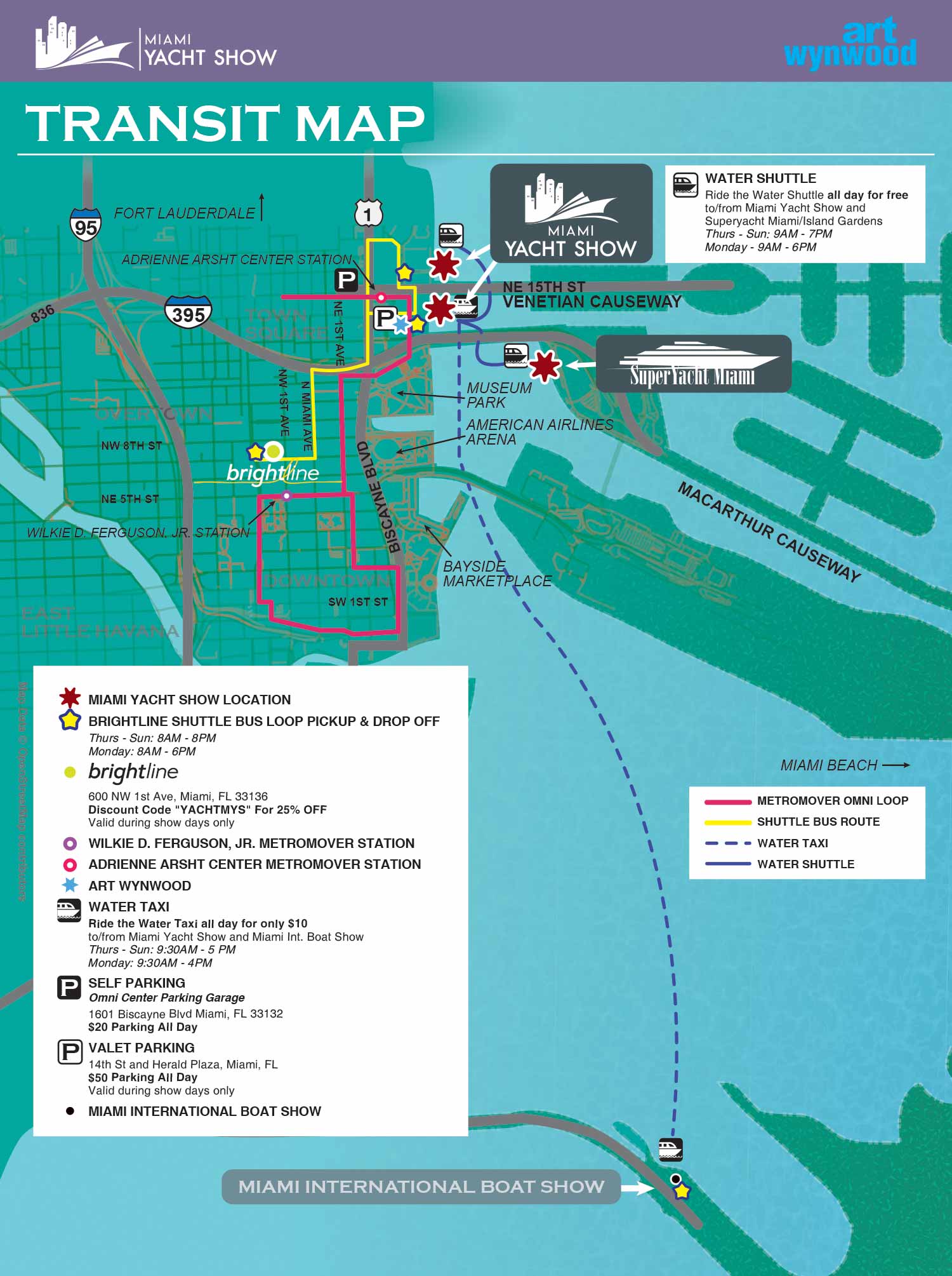
This is a vector based map created using geo data. The map helped visitors and exhibitors find buses and water taxis as well as parking and train access.
MAPS FOR BOAT SHOWS IN MIAMI:

Miami International Boat Show 2024

Miami Yacht Show 2020

Yacht and Brokerage Show

Convention Center Map

Sea Isle Marina Map

Miami Transit Map

Show Proposal Rendering

SuperYacht Miami Show

Bayside Miamarina Map

Miami Show Map

Miami Yacht Show Transit
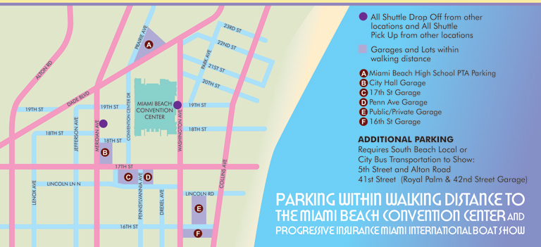
Miami Conv. Ctr. Parking
Maps For Boat Shows In Miami:
- Miami International Boat Show / Miami Yacht Show / Yachts Miami Beach / Miami Beach Yacht and Brokerage Show - Show Center/Primary Venue Maps: 2024 | 2023 | 2022 | 2020 | 2019 | 2018 | 2017 | 2016 | 2015 | 2014 | 2013 | 2012 | 2011
- Transit Map: 2023 | 2022 | 2020 | 2019 | 2016 | 2013
- SuperYacht Miami Show: 2020
- Miami Beach Convention Center: 2024 | 2023 | 2022 | 2013 | 2012
- Video: 2013
- Sea Isle Marina Only: 2013 | 2012
- Miamarina at Bayside Only: 2013 | 2012 | 2011
- Illustration (not a map): 2014
Miami International Boat Show Maps 2013:
Miami Beach Convention Center Map | New Yacht & Power Boat Show at Sea Isle MarinaStrictly Sail Miami at Miamarina Bayside | Miami International Boat Show Transit | Miami Beach Convention Center Parking
CUSTOM BOAT SHOW MAPS:

Fort Lauderdale International Boat Show Map
Boat Show in Miami Beach Map

Newport Beach International Boat Show Map

A New England Boat Show Map

Sarasota Boat Show Map

Boat Show Map

A South American Boat Show Map

Boat Show Illustrated Map

St. Pete Boat Show Map

Convention Center Map

Transportation Map Using GeoData
Boat Show Bus Routes Map

Illustrated Map of Marinas
Convention Center Map
SuperYacht Miami Show
Marina Map
Transit Map
Show Proposal Rendering

Yacht Club Map

Miami International Boat Show 2024

Transit & Parking Map
PORTFOLIOS:
- Illustration Portfolio
- Illustrated Maps Portfolio
- Fine Art
- Graphic Design Portfolio
- Motion Design
- Animated Illustrations
- Murals
- Architectural Rendering Portfolio
- Posters Portfolio
By Software Used:
By Application or Use:
- Boat Show Map Portfolio
- Resort Map Illustrations Portfolio
- Marina Maps Portfolio
- Transit, Parking and Transportation Maps Portfolio
- Town and City Maps Portfolio
- Cover Illustration Portfolio
- Vehicle Wrap & Vinyl Wrap Portfolio
- Illustrated Park Maps Portfolio
- Wayfinding Maps Portfolio
- Proposal Renderings Portfolio
- Street Art
- Real Estate Maps Portfolio