
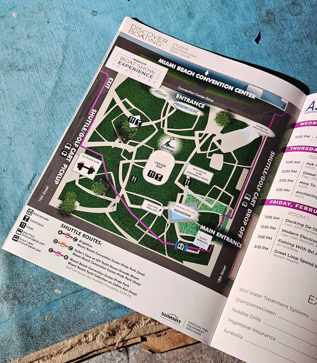
Pride Park - Illustrated Map - 2026
Client: Informa Markets
For information about the Miami International Boat Show and to ensure you're seeing the latest maps and information visit MiamiBoatShow.com

The Gathering Space Outside the Convention Center
Pride Park returns as a key part of the 2026 Miami International Boat Show. You will find it directly outside the Miami Beach Convention Center. The Progressive Boat Show Experience at Pride Park serves as a central gathering space for boating enthusiasts, and I designed it as an immersive lifestyle destination. Visitors of all ages can enjoy educational seminars, interactive exhibits, food and drink vendors, and dedicated activity zones. It is not just a place to pass through. It is a place to stay awhile.
Clean Vectors, Clear Information
I rendered this overhead map entirely as a vector graphic. That means maximum clarity at any size, whether someone views it on a phone screen or a twenty foot sign. The style is clean and semi illustrative. I labeled key features directly within the map so visitors do not have to bounce their eyes between a diagram and a separate key. A consistent icon system identifies amenities instantly, and a graphical shuttle route legend provides additional navigational context. Consequently, the map functions as both a practical wayfinding tool and a quick visual summary of the venue. It enhances the visitor experience while quietly reinforcing the scale and organization of the show itself.
One Show, Four Venues, Complete Coverage
The 2026 show spans four primary venues, and I produced a dedicated, custom designed map for each location. I also created a comprehensive transportation map with versions tailored for the show website, on site signage, and the official printed program. Additionally, I developed a vertical format map of the Miami Beach Yacht Collection along Collins Avenue specifically for large scale signage. The same visual language carries across every piece, but I adjusted each version for different viewing distances, format constraints, and physical environments.
Maps That Earn Their Place
Large public events rise or fall on clear, well organized maps. Visitors need to move confidently between exhibits, displays, and amenities, and confusion at any point undermines the entire experience. Beyond basic wayfinding, thoughtfully illustrated maps also reinforce branding and support marketing goals. They elevate the overall visitor experience in ways that generic signage cannot. I invite you to explore the rest of my portfolio for more examples of custom illustrated maps and visual solutions created for complex venues and high traffic events.
Miami International Boat Show Maps 2026:
Miami Beach Yacht Collection on Collins Ave | Yacht Haven Grande Miami | Miami Beach Convention Center Map | Transportation Map | Pride Park MapEXAMPLES OF MAPS CREATED FOR MIAMI BOAT SHOWS:


Maps For Boat Shows In Miami:
- About Miami Boat Shows
- Miami International Boat Show / Miami Yacht Show / Yachts Miami Beach / Miami Beach Yacht and Brokerage Show - Show Center/Primary Venue Maps: 2026 | 2025 | 2024 | 2023 | 2022 | 2020 | 2019 | 2018 | 2017 | 2016 | 2015 | 2014 | 2013 | 2012 | 2011
- Transportation Map: 2026 | 2025 | 2024 | 2023 | 2022 | 2020 | 2019 | 2016 | 2013 | 2012
- Program Layout: 2026 | 2025 | 2024 | 2023 | 2022
- Yacht Haven Grande at Island Gardens: 2026 | 2022 | 2020 | 2016
- Miami Beach Convention Center: 2026 | 2025 | 2024 | 2023 | 2022 | 2013 | 2012
- Sea Isle Marina Only: 2013 | 2012
- Miamarina at Bayside Only: 2013 | 2012 | 2011
- Bayfront Park: 2015
- Museum Park Marina: 2025 | 2024 | 2023 | 2022
- Illustration (not a map): 2014
- Video: 2013
PORTFOLIO SELECTIONS
- Custom illustration & covers: Featuring bespoke illustration, book and magazine covers, hand-drawn maps, and building renderings.
- Fine art & murals: Including one-of-a-kind paintings and drawings, the Custom Halftone Series, and large-scale murals.
- Design & motion media: Covering graphic design, plus video and motion and animated illustration.
- Mapping by application: Tailored maps for marine events, hospitality, waterfront, property, transit, municipal, recreation, and navigation needs.
- Additional creative work: Includes editorial covers, vehicle graphics, concept renderings, and public art.
- Mediums & formats: Ranging from digital vector and isometric projection to traditional paint, line art, GIS-based, aerial-style, and halftone.
- Software expertise: Proficient in Photoshop, Illustrator, SketchUp, InDesign, and Premiere/After Effects for motion. More recently I have worked with AI.
