
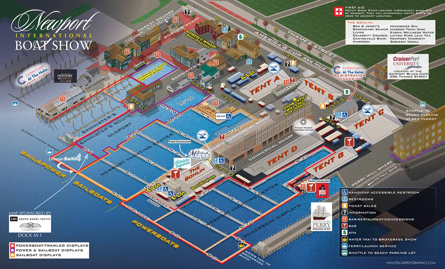
An illustrated guest map for the annual show
Client: The Newport Exhibition Group
About The Show
The Newport International Boat Show lands in historic downtown Newport, Rhode Island, every September. It covers more than seventeen acres across interconnected wharfs and sites including the Newport Yachting Center, Hammetts Hotel, Perry Mill Wharf, Bowen's Wharf, Bannisters Wharf, and Market Square. The setting is dense and charming, with the show blending into the surrounding neighborhood more than at most venues I work on.
It draws attendees from all over the Northeast and beyond, offering a look at hundreds of boats and marine exhibitors.
For 2016
This map is the revised version for the annual Newport International Boat Show. It builds on the axonometric vector illustration I first created for The Newport Exhibition Group in 2012.
By 2016, the map had been running for several years with the same basic approach. The viewing angle, the color palette, and the overall style were established and working well. My job for this year was to update the things that change from show to show.
That meant adjusting the floating dock layouts and land exhibitor placements to match the 2016 plan. It also meant checking every label to make sure the information was current. When you have a map that people rely on to navigate a large event, getting those details right matters.
The map kept the same isometric perspective from the harbor looking inland. That angle gives a clear view of the layout while capturing the character of the Newport waterfront. The colors stayed earthy and muted, fitting the New England setting.
Why A Map Matters
A good map does more than point the way. Yes, it helps attendees find the exhibits they came to see. But it also works before the show even starts.
People study the map online. They pick out the docks they want to visit. They start imagining themselves there. That builds anticipation. For exhibitors, being on that map means being part of that pre show experience. And for the show itself, a consistent map year after year becomes part of its identity.
What I Can Do For You
If you manage an event or run a venue that needs a clear, detailed map, I can help. I have been making illustrated maps for boat shows, resorts, marinas, and more since 2012. Contact me and tell me about your project. I would be glad to put this experience to work for you.
Maps For Newport International Boat Show:
- About Newport International Boat Show
- Main Map: 2025 | 2024 | 2023 | 2022 | 2021 | 2019 | 2018 | 2017 | 2016 | 2015 | 2014 | 2013 | 2012
- Tent Details Map: 2017 | 2016 | 2015 | 2014 | 2013 | 2012
- Video: 2012
PORTFOLIOS
- Illustration Portfolio: Start here for custom illustration and book covers. You can also browse illustrated maps and architectural rendering.
- Fine Art: I offer original paintings and drawings, including my Custom Halftone Series. You will also find mural work here.
- Graphic Design & Motion: View my graphic design portfolio. After that, explore motion design and animated illustrations.
- Maps by application: I create illustrated maps for boat shows, resorts, marinas, real estate, transportation, transit and parking, towns and cities, parks, and wayfinding.
- Additional project types: I also produce cover illustration, vehicle and vinyl wraps, proposal renderings, and street art.
- Illustration methods: My techniques include vector, isometric and axonometric, painting, black and white, GeoData maps, overhead maps, and custom halftones.
- Software portfolios: I work primarily in Adobe Photoshop, Adobe Illustrator, SketchUp Pro, and Adobe InDesign. For motion projects, I use Premiere Pro and After Effects.