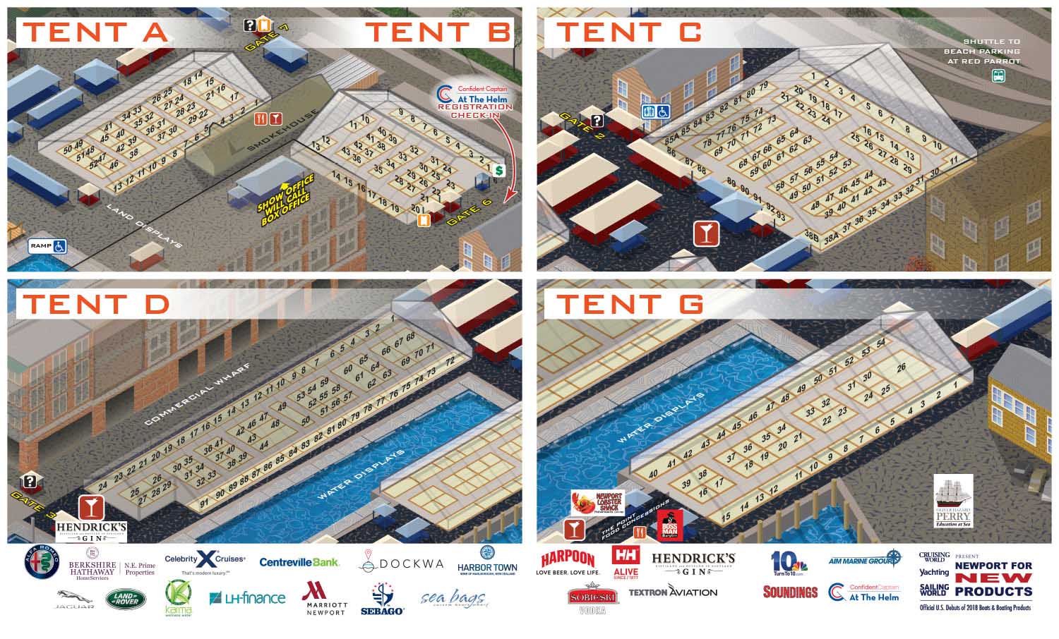
Detailed tent layouts for land based exhibitors at the Newport International Boat Show.
Client: The Newport Exhibition Group
About The Show
The Newport International Boat Show takes over more than thirteen acres of downtown Newport, Rhode Island, each September. It draws visitors from across the country to see sailboats and powerboats, including models shown in the US for the first time. On land, exhibitors fill tents and outdoor spaces with marine gear, services, and accessories. The schedule also includes seminars, on water courses, and daily drawings.
Newport itself is part of the draw. The waterfront has wide coastal views, and the historic downtown is full of shops and restaurants. A day at the boat show easily turns into a longer visit to one of New England's most scenic cities.
About These Maps
These detailed maps show the land exhibit areas within the larger 2017 show. They are taken from the main show map I created that year.
Because the main map was built as a vector illustration in Adobe Illustrator, I could zoom in on specific areas without losing any sharpness. The booth numbers and individual vendor locations would have been too small to read on the full size map. These close up views solved that problem.
The idea was simple. By keeping the same angle and style as the main map, these tent layouts would feel familiar to anyone who had already looked at the overall show guide. A visitor could go from the big picture to the fine details and still know where they were.
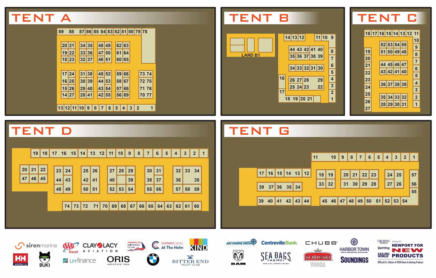
Around 2019, I stopped posting these maps individually. They are literally different each year, but they look extremely similar and there was little new to say from year to year.
In 2019 we switched to a more minimalistic approach. The new maps were simple overhead diagrams made in Illustrator. They lost the visual connection to the main illustrated map, but they were clean and to the point. In following years the colors and some styling changed, but that overhead approach has remained in the following years. Both techniques have their own strengths, and which one works best depends on the needs of the show.
Why A Map Matters
A good illustrated map does more than guide someone from point A to point B. It sets expectations before the event even starts.
People look at maps online while planning their visit. They pick out the tents they want to hit and the docks they want to walk. That mental rehearsal builds anticipation. For vendors, being clearly shown on the map means being part of that planning process. And for an event that happens year after year, a consistent map style becomes part of how people recognize the show.
What I Can Do For You
If you run an event or manage a venue that needs attractive, detailed mapping, I can help. I have been making illustrated maps for boat shows, resorts, marinas, and more for over a decade. Contact me and tell me about your project. I would be glad to put this experience to work for you.
Maps For Newport International Boat Show:
- About Newport International Boat Show
- Main Map: 2025 | 2024 | 2023 | 2022 | 2021 | 2019 | 2018 | 2017 | 2016 | 2015 | 2014 | 2013 | 2012
- Tent Details Map: 2017 | 2016 | 2015 | 2014 | 2013 | 2012
- Video: 2012
PORTFOLIOS
- Illustration Portfolio: Start here for custom illustration and book covers. You can also browse illustrated maps and architectural rendering.
- Fine Art: I offer original paintings and drawings, including my Custom Halftone Series. You will also find mural work here.
- Graphic Design & Motion: View my graphic design portfolio. After that, explore motion design and animated illustrations.
- Maps by application: I create illustrated maps for boat shows, resorts, marinas, real estate, transportation, transit and parking, towns and cities, parks, and wayfinding.
- Additional project types: I also produce cover illustration, vehicle and vinyl wraps, proposal renderings, and street art.
- Illustration methods: My techniques include vector, isometric and axonometric, painting, black and white, GeoData maps, overhead maps, and custom halftones.
- Software portfolios: I work primarily in Adobe Photoshop, Adobe Illustrator, SketchUp Pro, and Adobe InDesign. For motion projects, I use Premiere Pro and After Effects. You can watch my demo reel here.