Custom detailed maps for land based exhibitors at the Newport International Boat Show
Client: The Newport Exhibition Group
About The Show
The Newport International Boat Show spans more than thirteen acres of downtown Newport, Rhode Island, each September. It is one of the largest boat shows in the Northeast, drawing visitors from across the country. Attendees come to see new sailboats and powerboats, shop for marine gear from hundreds of exhibitors, and take part in seminars and on water courses.
Newport's historic waterfront provides the backdrop. The setting has wide coastal views, charming streets, and plenty of shops and restaurants. A day at the show easily becomes a longer visit to one of New England's most popular destinations.
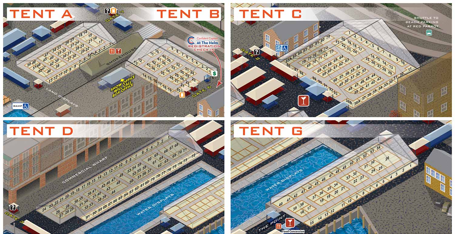
About This Map
This map shows the land exhibit areas for the 2016 show. It is a custom detail pulled from the main show map I created that year.
The main map was built as a vector illustration, which means I could zoom in on any area without losing sharpness. That matters because booth numbers and vendor names are too small to read on the full size map. These detailed views give visitors the information they actually need when they are standing in front of a row of tents.
The style matches the main map exactly. The same angles, the same colors, the same look. That continuity helps people move between the big picture and the close up view without confusion.
Custom Maps For Your Event
Every event has its own challenges. These tent maps are a good example of how a custom approach can solve a specific problem. The main map orients visitors. The detail maps help them zero in on exactly where they want to go.
If your event has land based exhibitors, custom detail maps make it easier for attendees to find what they are looking for and easier for vendors to get found.
What I Can Do For You
If you need custom illustrated maps for an event or venue, I can help. I have been making maps for boat shows, resorts, marinas, and more since 2012. Contact me and tell me about your project.
Maps For Newport International Boat Show:
- About Newport International Boat Show
- Main Map: 2025 | 2024 | 2023 | 2022 | 2021 | 2019 | 2018 | 2017 | 2016 | 2015 | 2014 | 2013 | 2012
- Tent Details Map: 2017 | 2016 | 2015 | 2014 | 2013 | 2012
- Video: 2012
PORTFOLIOS
- Illustration Portfolio: Start here for custom illustration and book covers. You can also browse illustrated maps and architectural rendering.
- Fine Art: I offer original paintings and drawings, including my Custom Halftone Series. You will also find mural work here.
- Graphic Design & Motion: View my graphic design portfolio. After that, explore motion design and animated illustrations.
- Maps by application: I create illustrated maps for boat shows, resorts, marinas, real estate, transportation, transit and parking, towns and cities, parks, and wayfinding.
- Additional project types: I also produce cover illustration, vehicle and vinyl wraps, proposal renderings, and street art.
- Illustration methods: My techniques include vector, isometric and axonometric, painting, black and white, GeoData maps, overhead maps, and custom halftones.
- Software portfolios: I work primarily in Adobe Photoshop, Adobe Illustrator, SketchUp Pro, and Adobe InDesign. For motion projects, I use Premiere Pro and After Effects.