MIBS 2025 Show Program
For more (and more up to date) information about the 2025 Miami International Boat Show visit their official site at MiamiBoatShow.com.
I am the guy who designs and illustrates the maps used for the show and the page layout of the program.
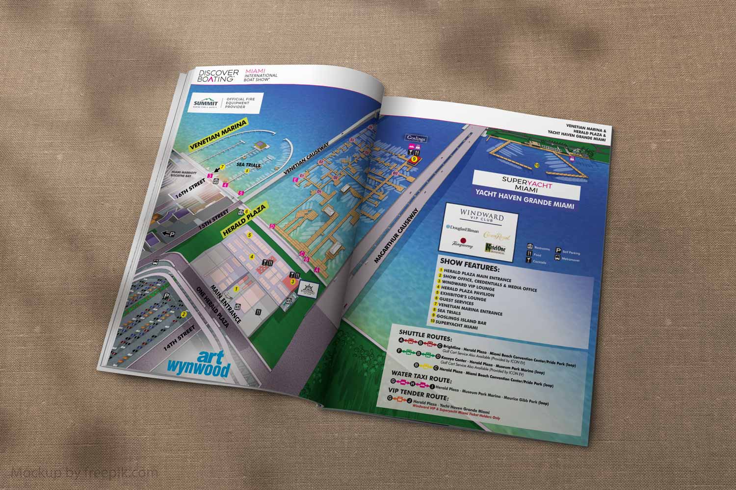
I did the page layout for the show program. It's just over twenty pages chock full of information to help maximize your time including my many map designs.
Page layout and tables were designed in Adobe InDesign. The maps are a combination of Sketchup Pro, Adobe Illustrator and Adobe Photoshop.
* I did not design the cover or back cover and there are a few pages in there that were supplied by Informa Markets staff.
The whole thing is pretty collaborative. Thanks to the staff at Informa Markets.
If you would like to see more of my maps please see my portfolio.
EXAMPLES OF MAPS CREATED FOR MIAMI BOAT SHOWS:


Miami International Boat Show Maps 2025:
Venetian Marina and One Herald Plaza | Museum Park | Miami Beach Convention Center Map | Transportation Map | Pride Park Map | Program LayoutMaps For Boat Shows In Miami:
- About Miami Boat Shows
- Miami International Boat Show / Miami Yacht Show / Yachts Miami Beach / Miami Beach Yacht and Brokerage Show - Show Center/Primary Venue Maps: 2026 | 2025 | 2024 | 2023 | 2022 | 2020 | 2019 | 2018 | 2017 | 2016 | 2015 | 2014 | 2013 | 2012 | 2011
- Transportation Map: 2026 | 2025 | 2024 | 2023 | 2022 | 2020 | 2019 | 2016 | 2013 | 2012
- Program Layout: 2026 | 2025 | 2024 | 2023 | 2022
- Yacht Haven Grande at Island Gardens: 2026 | 2022 | 2020 | 2016
- Miami Beach Convention Center: 2026 | 2025 | 2024 | 2023 | 2022 | 2013 | 2012
- Sea Isle Marina Only: 2013 | 2012
- Miamarina at Bayside Only: 2013 | 2012 | 2011
- Bayfront Park: 2015
- Museum Park Marina: 2025 | 2024 | 2023 | 2022
- Illustration (not a map): 2014
- Video: 2013


PORTFOLIO SELECTIONS
- Custom illustration & covers: Featuring bespoke illustration, book and magazine covers, hand-drawn maps, and building renderings.
- Fine art & murals: Including one-of-a-kind paintings and drawings, the Custom Halftone Series, and large-scale murals.
- Design & motion media: Covering graphic design, plus video and motion and animated illustration.
- Mapping by application: Tailored maps for marine events, hospitality, waterfront, property, transit, municipal, recreation, and navigation needs.
- Additional creative work: Includes editorial covers, vehicle graphics, concept renderings, and public art.
- Mediums & formats: Ranging from digital vector and isometric projection to traditional paint, line art, GIS-based, aerial-style, and halftone.
- Software expertise: Proficient in Photoshop, Illustrator, SketchUp, InDesign, and Premiere/After Effects for motion.