
For information about the Miami International Boat Show and to ensure you're seeing the latest maps and information visit MiamiBoatShow.com

The Hub of the Show
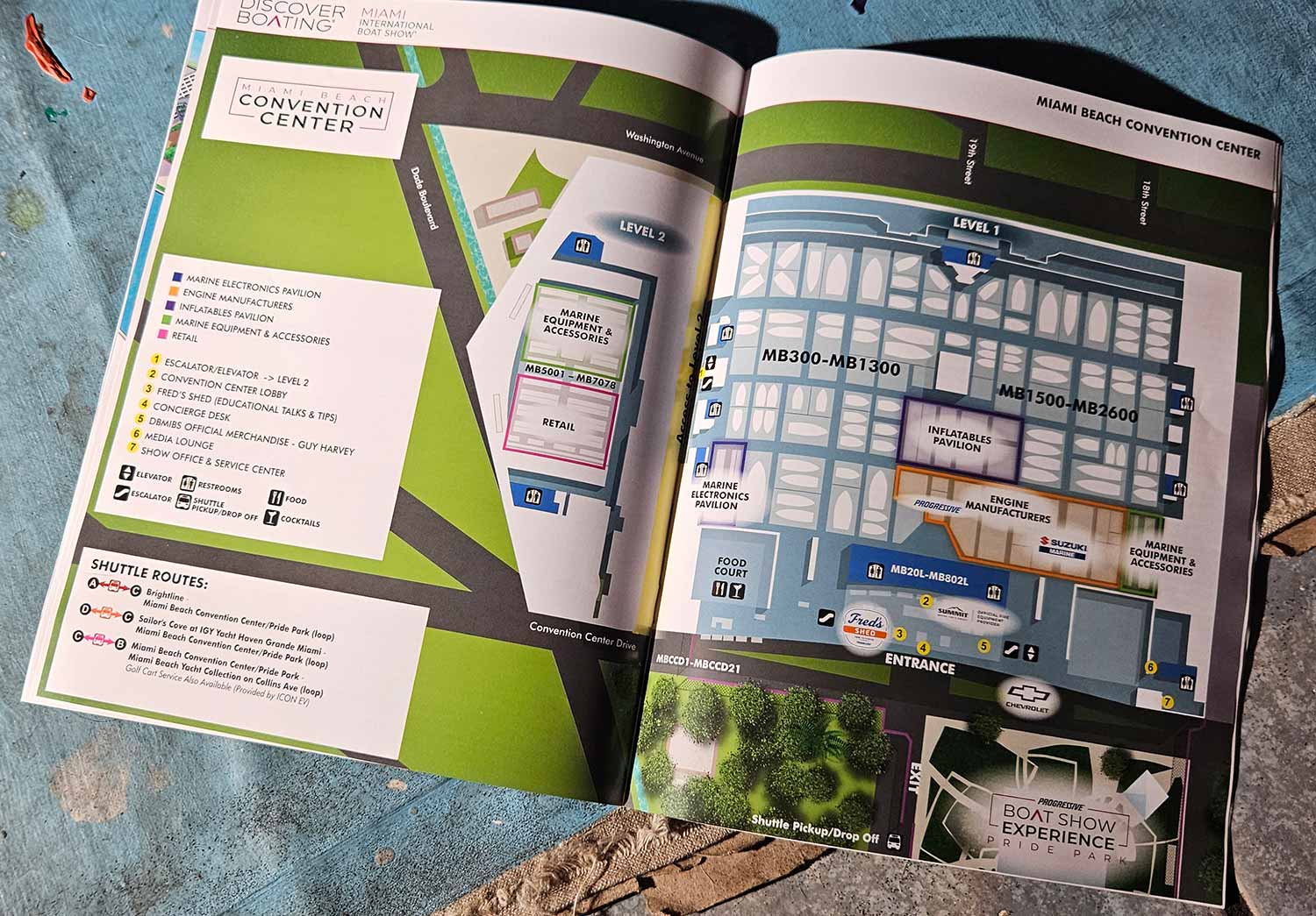
The Miami Beach Convention Center anchors the 2026 Miami International Boat Show once again. It is one of the most recognizable and accessible venues in the city, and it serves as the primary hub for the entire event. Visitors find expansive indoor exhibits, marine industry displays, and coordinated transportation options all in one place. Because the convention center connects conveniently to every other show location, it functions as the natural starting point for anyone navigating the show.
Clear Orientation at a Glance
I designed this overhead map as a straightforward orientation tool for attendees entering the convention center area. Restrained color and subtle texture distinguish different zones without overwhelming the viewer. A consistent graphical icon system identifies commonly used amenities, and numbered yellow markers call out key show features. I also assigned distinct color zones to specific sectors of the marine industry, which helps attendees locate exhibits related to their interests right away. A clear graphical legend outlines shuttle route information. Additionally, I included a portion of Pride Park, which borders the convention center, to provide extra geographic context and improve overall wayfinding.
One Show, Four Venues, Consistent Language
The 2026 show spans four primary venues, and I supported each one with a dedicated, location specific map. Beyond those venue maps, I designed a comprehensive transportation map with versions optimized for the show website, on site signage, and the official printed program. I also developed a vertical format map of the Miami Beach Yacht Collection along Collins Avenue specifically for large scale signage. Consequently, the same visual language remains clear and consistent across different formats, viewing distances, and spatial conditions.
Maps That Earn Their Place
Large public events depend on clear, well organized maps. Visitors need to move efficiently between exhibits, displays, and amenities, and a confusing map undermines everything else. When thoughtfully designed, event maps also function as effective marketing tools. They reinforce branding, support wayfinding, and elevate the overall visitor experience. I invite you to explore the rest of my portfolio for more examples of illustrated maps and custom visual solutions created for complex venues and high traffic environments.
Miami International Boat Show Maps 2026:
Miami Beach Yacht Collection on Collins Ave | Yacht Haven Grande Miami | Miami Beach Convention Center Map | Transportation Map | Pride Park MapEXAMPLES OF MAPS CREATED FOR MIAMI BOAT SHOWS:


Maps For Boat Shows In Miami:
- About Miami Boat Shows
- Miami International Boat Show / Miami Yacht Show / Yachts Miami Beach / Miami Beach Yacht and Brokerage Show - Show Center/Primary Venue Maps: 2026 | 2025 | 2024 | 2023 | 2022 | 2020 | 2019 | 2018 | 2017 | 2016 | 2015 | 2014 | 2013 | 2012 | 2011
- Transportation Map: 2026 | 2025 | 2024 | 2023 | 2022 | 2020 | 2019 | 2016 | 2013 | 2012
- Program Layout: 2026 | 2025 | 2024 | 2023 | 2022
- Yacht Haven Grande at Island Gardens: 2026 | 2022 | 2020 | 2016
- Miami Beach Convention Center: 2026 | 2025 | 2024 | 2023 | 2022 | 2013 | 2012
- Sea Isle Marina Only: 2013 | 2012
- Miamarina at Bayside Only: 2013 | 2012 | 2011
- Bayfront Park: 2015
- Museum Park Marina: 2025 | 2024 | 2023 | 2022
- Illustration (not a map): 2014
- Video: 2013
BROWSE MY WORK
- Illustration: Browse custom illustrations, book cover art, illustrated maps, and architectural renderings.
- Fine art: View original paintings and drawings, the Custom Halftone Series, and mural commissions.
- Graphic design & motion: See design projects, then watch motion reels and animated pieces.
- Maps by use case: Explore illustrated maps created for boat shows, resorts, marinas, real estate, transportation & parking, cities & towns, parks, and wayfinding.
- Specialty projects: Also check out cover design, vinyl & vehicle wraps, proposal renderings, and street art.
- Style & technique: Discover vector, isometric, painterly, monochrome, data-driven, bird's-eye, and halftone approaches.
- Tools I use: Everyday software includes Photoshop, Illustrator, SketchUp, and InDesign; motion work relies on Premiere & After Effects. Recently I have begun some work using AI as well.
