Drawn map of a boat show for guest use
Client: Show Management
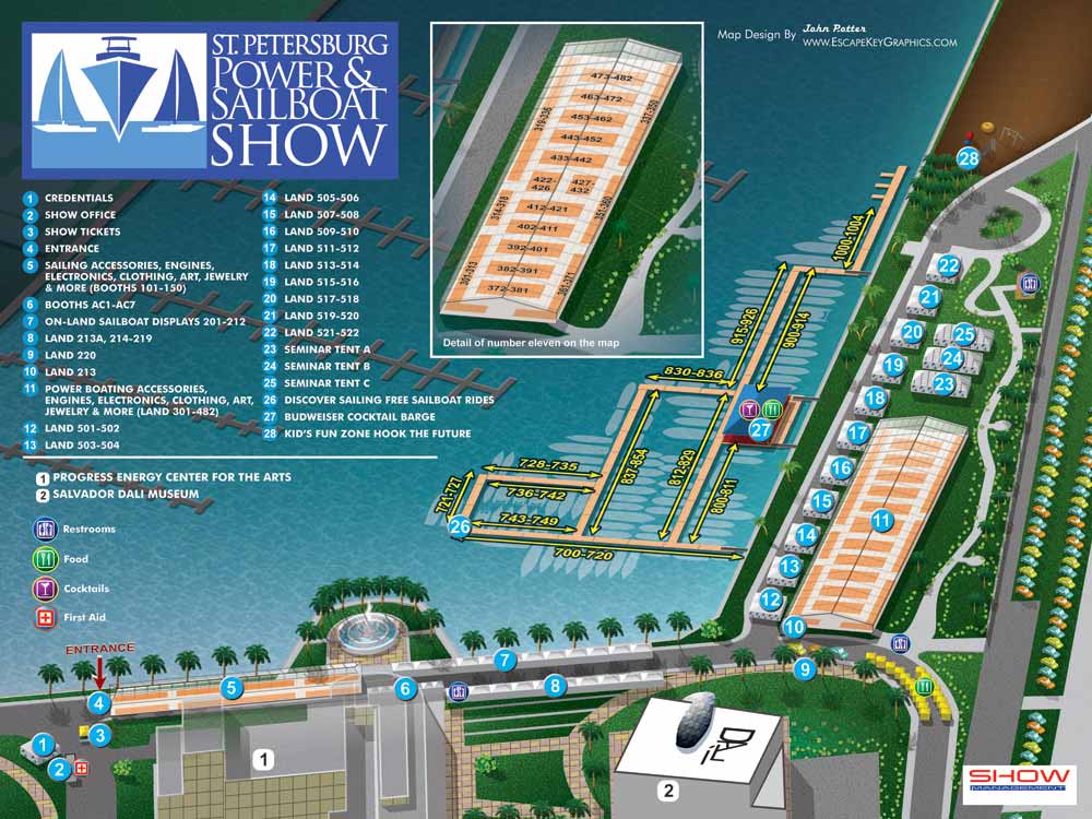
This project marked my inaugural year as the illustrator and designer for the official map of the St. Petersburg Power and Sailboat Show. The commission involved creating a clear, engaging, and highly functional guide for one of Florida's premier marine events, held in the city's beautiful downtown waterfront district.
To achieve a crisp, readable overview of the expansive show area, I employed an axonometric drawing technique. This method, which presents a three dimensional view without perspective distortion, allowed me to construct the entire map as a precise vector based illustration. This foundation ensured graphical clarity at any scale, from a printed guide to a digital display.
The show utilized a significant portion of the St. Petersburg Waterfront Museum District. The main attractions were the land displays at Albert Whitted Park and the extensive floating docks anchored there, supplemented by additional exhibitors along Bayshore Drive SE. To provide crucial orientation for visitors, I also included key local landmarks like the iconic Dalí Museum and the Duke Energy Center for the Arts. While these cultural institutions were not part of the show itself, their inclusion on the map helped attendees navigate with ease.
A streamlined, intuitive keying system was essential for managing the high volume of exhibitors and points of interest. I implemented a color coded numerical system: blue dots with numbers identified official show points of interest, while white dots marked general landmarks. Amenities were communicated through a set of universally understood graphical icons, allowing for instant recognition.
For detailed navigation within the most densely populated areas, the map featured an enlarged, detailed inset of the largest exhibitor tent, clearly outlining booth locations by numbered spans. A similar system was applied to the marina docks, where sequences of numbers (e.g., 830-836) precisely indicated each exhibitor's slip location, making it simple for attendees to find specific vendors on the water.
This map set the standard for my ongoing work in event wayfinding, balancing artistic illustration with rigorous informational design to serve both Show Management and their visitors effectively.
St. Petersburg Power & Sailboat Show Maps
- About St. Petersburg Power & Sailboat Show
- 2026 | 2025 | 2024 | 2023 | 2022 | 2021 | 2019 | 2018 | 2017 | 2016 | 2015 | 2014 | 2013 | 2012 | 2011


