St. Petersburg Boat Show Map 2022
Client: Informa Markets
For information on attending the Saint Petersburg Power and Sailboat Show please visit StPeteBoatShow.com
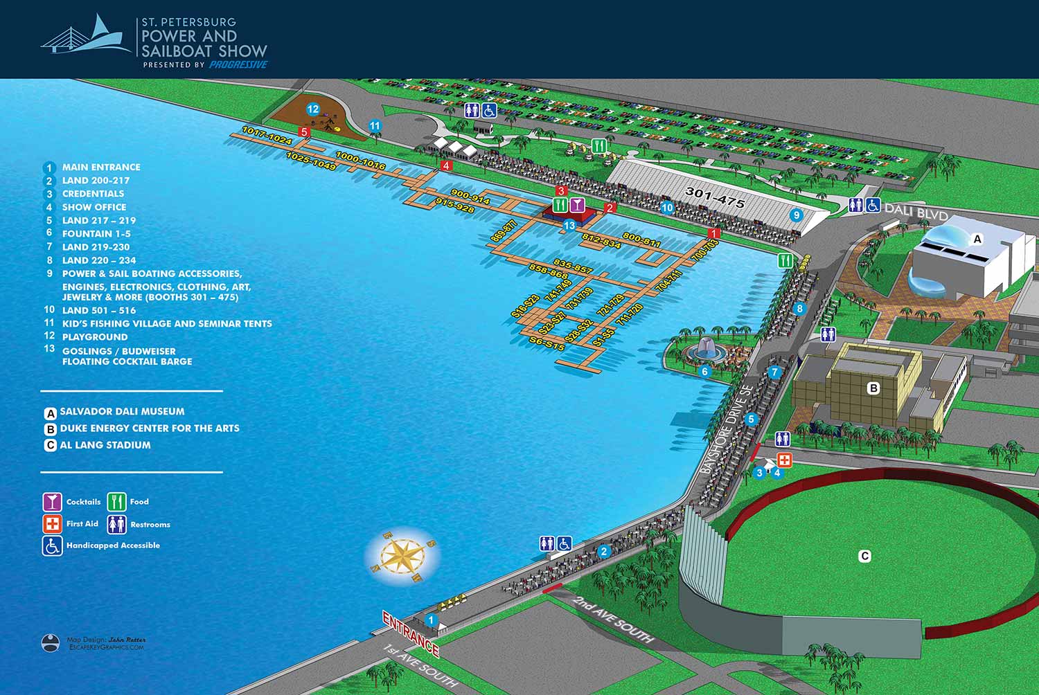
For the 2022 Saint Petersburg Power and Sailboat Show, the illustrated map once again demonstrated the strength of its foundational design by requiring no major structural alterations. This practical and efficient approach underscores the value of a proven, effective visual tool. A minimal need for redesign is a clear hallmark of a solid initial layout. This consistency provides significant value, as returning visitors appreciate the comfort and intuitive ease of a familiar guide, allowing them to navigate the event with confidence from the moment they arrive.
Illustration Process: A Foundation of Accuracy
The illustration is generated from the established three dimensional digital master model, which I maintain as the consistent and precise geographic foundation for this event. This model ensures annual accuracy while streamlining the update process. The primary task for 2022 involved revising this model to reflect the current year's specific arrangements for floating docks and land based displays. After these meticulous updates, the 3D scene is rendered to create a high fidelity base image. This rendering is then carefully refined and prepared in Adobe Photoshop, where lighting, color balance, and textural details are adjusted to achieve the final illustrative quality that is both informative and visually engaging.
Graphic Design Integration: Clarity and Refinement
The informational graphics and typography are meticulously layered onto the completed illustration. This year, the header design was made slightly more robust while intentionally retaining the established look and feel for brand continuity. The map incorporated the necessary annual updates: the specific locations and corresponding text listings for points of interest were revised. In a move towards greater simplicity, these listings were consolidated into a shorter, more focused list than in previous years. The positions of the graphical icons for amenities were adjusted as needed, though the intuitive icon key itself remained unchanged. The separate key identifying nearby buildings was carried over with one notable and practical addition: Al Lang Stadium was included to aid with orientation and planning for attendees.
The Value of Professional Illustrated Cartography
This project exemplifies how professional illustrated event maps serve a dual purpose. They are indispensable operational tools during the show, yet their strategic value begins much earlier. Published online ahead of the event, they function as powerful marketing assets, replacing generic imagery with concrete, useful information. Potential attendees can plan their visit, visualize the layout, and locate key features, which builds anticipation and reduces onsite uncertainty.
As an experienced map illustrator specializing in complex venues, I create detailed, accurate, and user friendly maps that enhance the visitor experience and support event marketing goals. This map for the Saint Petersburg Power and Sailboat Show is part of a long term collaboration, detailed further on my project overview page.
For more examples of my illustrative cartography for marine events, please visit my Maps Portfolio.
St. Petersburg Power & Sailboat Show Maps
- About St. Petersburg Power & Sailboat Show
- 2026 | 2025 | 2024 | 2023 | 2022 | 2021 | 2019 | 2018 | 2017 | 2016 | 2015 | 2014 | 2013 | 2012 | 2011


PORTFOLIOS
- Illustration Portfolio: Start here for custom illustration and book covers. You can also browse illustrated maps and architectural rendering.
- Fine Art: I offer original paintings and drawings, including my Custom Halftone Series. You will also find mural work here.
- Graphic Design & Motion: View my graphic design portfolio. After that, explore motion design and animated illustrations.
- Maps by application: I create illustrated maps for boat shows, resorts, marinas, real estate, transportation, transit and parking, towns and cities, parks, and wayfinding.
- Additional project types: I also produce cover illustration, vehicle and vinyl wraps, proposal renderings, and street art.
- Illustration methods: My techniques include vector, isometric and axonometric, painting, black and white, GeoData maps, overhead maps, and custom halftones.
- Software portfolios: I work primarily in Adobe Photoshop, Adobe Illustrator, SketchUp Pro, and Adobe InDesign. For motion projects, I use Premiere Pro and After Effects.