
Bayside Miami Marina Map for Strictly Sail Miami, 2012
Client: National Marine Manufacturers Association
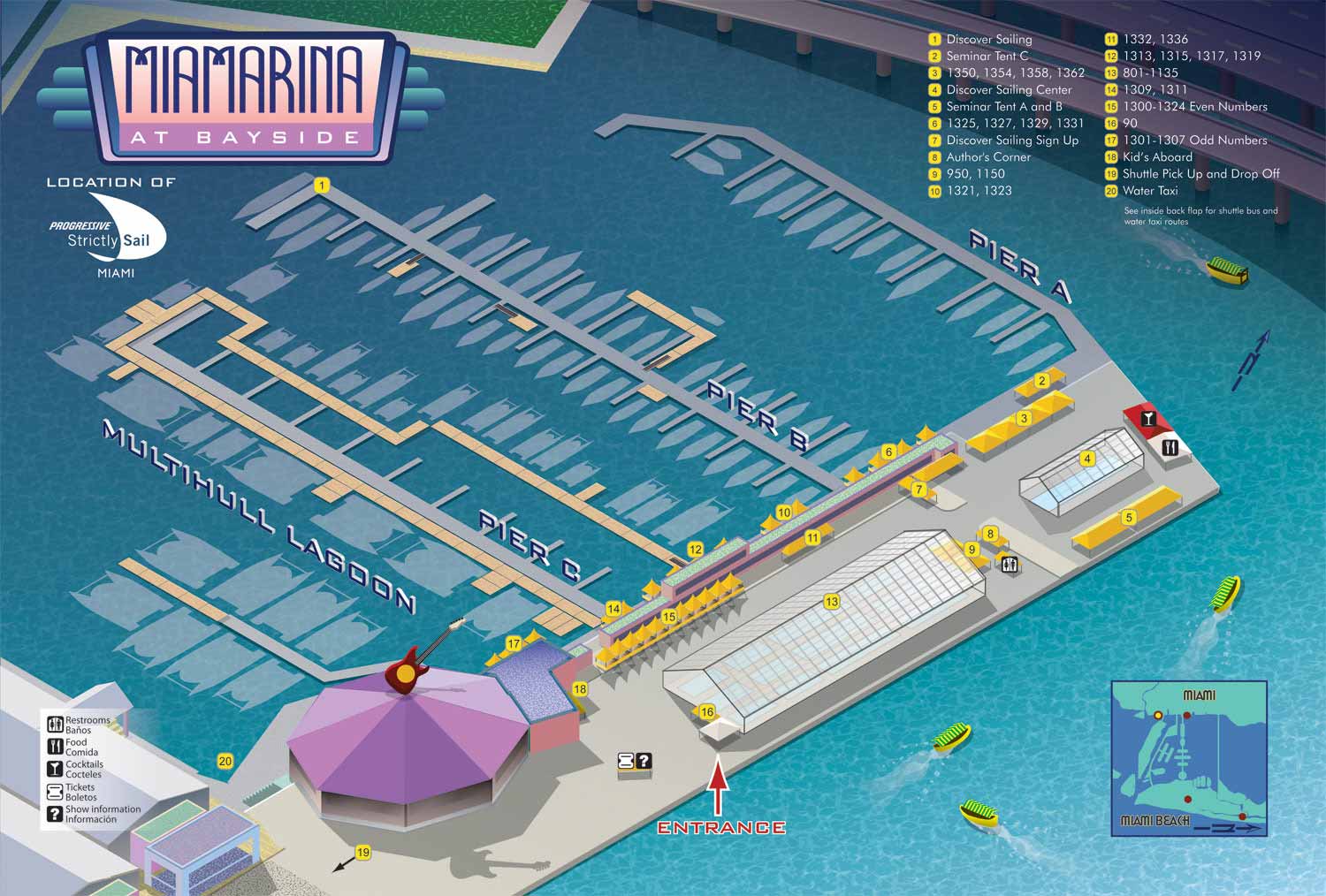
This illustrated map was commissioned for Strictly Sail Miami in 2012, depicting the event venue at Miamarina at Bayside in downtown Miami, Florida. The map was designed with a dual purpose: to provide unambiguous navigation for attendees while visually capturing the distinctive character and energy of its iconic waterfront location.
To present the marina, docks, and surrounding features in a spatially intuitive format, I employed an isometric perspective. This three quarter view allows the viewer to grasp the layout and relationships between elements more naturally than a flat overhead plan. The color palette was carefully chosen to reflect the vibrant, coastal atmosphere of South Florida. Furthermore, subtle Art Deco design influences were woven into the illustration, a deliberate nod to Miami's rich architectural history and enduring design culture. This fusion of geographic accuracy and stylistic flair ensures the map functions simultaneously as a precise wayfinding tool and an engaging visual piece. An inset map provides essential geographical context, situating the marina within the greater Miami area and indicating the locations of other simultaneous events.
For practical navigation, each individual dock is clearly labeled, enabling boaters and exhibitors to identify their assigned spaces quickly. Important destinations and amenities throughout the venue are marked with a straightforward numbered system, using prominent yellow dots that correspond to a simple legend for instant reference. This approach prioritizes immediate usability.
The final result is a clean, approachable, and professional map that successfully balances functional clarity with a strong sense of place. It was well suited for integration into the official event program, for use on onsite signage, and as a key component of promotional materials, effectively supporting both the logistics and the atmosphere of the show.
EXAMPLES OF MAPS CREATED FOR MIAMI BOAT SHOWS:


Maps For Boat Shows In Miami:
- About Miami Boat Shows
- Miami International Boat Show / Miami Yacht Show / Yachts Miami Beach / Miami Beach Yacht and Brokerage Show - Show Center/Primary Venue Maps: 2026 | 2025 | 2024 | 2023 | 2022 | 2020 | 2019 | 2018 | 2017 | 2016 | 2015 | 2014 | 2013 | 2012 | 2011
- Transportation Map: 2026 | 2025 | 2024 | 2023 | 2022 | 2020 | 2019 | 2016 | 2013 | 2012
- Program Layout: 2026 | 2025 | 2024 | 2023 | 2022
- Yacht Haven Grande at Island Gardens: 2026 | 2022 | 2020 | 2016
- Miami Beach Convention Center: 2026 | 2025 | 2024 | 2023 | 2022 | 2013 | 2012
- Sea Isle Marina Only: 2013 | 2012
- Miamarina at Bayside Only: 2013 | 2012 | 2011
- Bayfront Park: 2015
- Museum Park Marina: 2025 | 2024 | 2023 | 2022
- Illustration (not a map): 2014
- Video: 2013
Miami International Boat Show Maps 2012:
Miami Beach Convention Center Map | Bayside Map | Sea Isle Marina MapYacht and Brokerage Show Parking and Shuttles


EXPLORE MY WORK
- Illustration: Discover custom illustrations, book covers, illustrated maps, and architectural renderings.
- Fine Art: Browse original paintings and drawings, view the Custom Halftone Series, or check out mural projects.
- Graphic Design & Motion: See the graphic design collection, then dive into motion design and animated illustrations.
- Maps by industry: View illustrated maps tailored for boat shows, resorts, marinas, real estate, transportation, towns, parks, and wayfinding.
- More project types: Explore cover art, vehicle wraps, proposal renderings, and street art.
- Techniques & styles: Work spans vector, isometric, painting, black-and-white, GeoData, overhead maps, and halftones.
- Software expertise: Primary tools include Photoshop, Illustrator, SketchUp Pro, and InDesign, plus Premiere Pro & After Effects for motion. I am also supplementing some projects with AI.