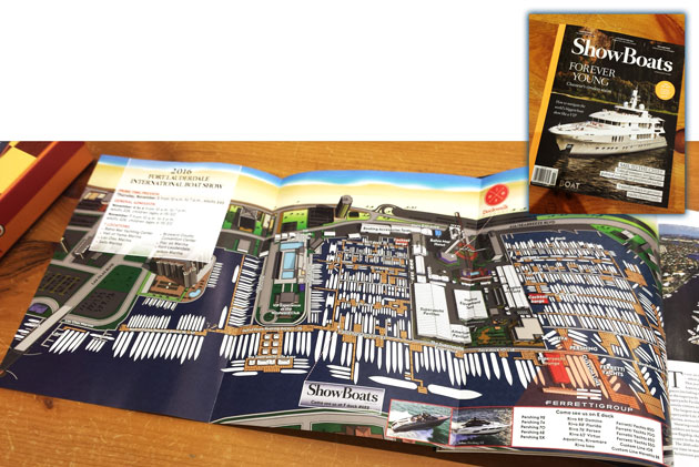
ShowBoats International Magazine Illustrated Map - Fort Lauderdale International Boat Show 2016
Client: Show Management
For information about the Fort Lauderdale International Boat Show visit FLIBS.com
ShowBoats International Magazine Feature: FLIBS 2016 Illustrated Map
My illustrated map of the Fort Lauderdale International Boat Show is featured as a foldout in the November 2016 issue of ShowBoats International Magazine. The superior print quality and high grade paper stock perfectly complement the detail of the artwork, aligning with the exemplary standard of the full publication. It was a genuine pleasure to collaborate once more with the magazine’s accomplished Art Director, Dan Brooks, on this feature.
This map is generated from the same three dimensional digital model that forms the foundational geographic resource for my maps of this venue at the Fort Lauderdale International Boat Show. Developing this precise model relies on the cooperation of the event's producer, Show Management. Any derivative commercial application of this model is conducted solely with their prior authorization, maintaining a clear respect for the associated intellectual property.
This publication highlights the continued versatility of the digital model I maintain and regularly update. The model provides the capability to produce accurate maps from almost any viewpoint or level of detail. The chance to craft a distinctive piece for a respected industry publication like ShowBoats International Magazine was both a rewarding professional experience and an honor.
To explore additional examples of my cartography and illustration work, please visit my Maps Portfolio.
Fort Lauderdale International Boat Show Maps:
- About Fort Lauderdale International Boat Show
- Bahia Mar, Swimming Hall of Fame & Las Olas Marina Maps: 2025 | 2024 | 2023 | 2022 | 2020 | 2019 | 2018 | 2017 | 2016 | 2015 | 2014 | 2013 | 2012 | 2011 | 2010
- Parking and Transportation Maps: 2025 | 2024 | 2023 | 2022 | 2020 | 2019 | 2018 | 2015 Bus | 2015 Water Taxi | 2014 | 2013 | 2012 | 2011
- Broward County Convention Center Maps: 2025 | 2024 | 2023 | 2022 | 2017 Sailfish Pavilion | 2017 | 2016 Sailfish Pavilion | 2016 | 2015 Sailfish Pavilion | 2015 | 2014 Sailfish Pavilion | 2014 | 2013 Sailfish Pavilion | 2013 | 2012 | 2011 | 2010
- Marinas Maps: 2025 | 2024 | 2023 | 2022 | 2019 | 2016
- Program Layouts: 2025 | 2024 | 2023 | 2022
- Signs: 2013 looking north | 2013 Yachting Tent
- Video: 2013 54th Annual
- Illustrations (not maps): 2014A | 2014B


BROWSE MY WORK
- Illustration: Browse custom illustrations, book cover art, illustrated maps, and architectural renderings.
- Fine art: View original paintings and drawings, the Custom Halftone Series, and mural commissions.
- Graphic design & motion: See design projects, then watch motion reels and animated pieces.
- Maps by use case: Explore illustrated maps created for boat shows, resorts, marinas, real estate, transportation & parking, cities & towns, parks, and wayfinding.
- Specialty projects: Also check out cover design, vinyl & vehicle wraps, proposal renderings, and street art.
- Style & technique: Discover vector, isometric, painterly, monochrome, data-driven, bird's-eye, and halftone approaches.
- Tools I use: Everyday software includes Photoshop, Illustrator, SketchUp, and InDesign; motion work relies on Premiere & After Effects.