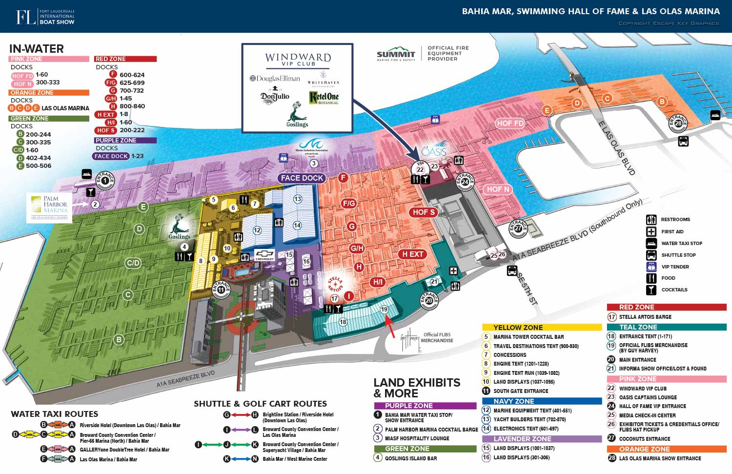
FLIBS 2024 Illustrated Map
Illustration and Design by John Potter - Escape Key Graphics
Project Management by Emma Wright - Informa Marketing
I illustrated and designed this map. If you are interested in more about my work please enjoy my site.
For more (and more recent) information about the 2024 Fort Lauderdale International Boat Show visit their official site at FLIBS.com.
Project Management by Emma Wright - Informa Marketing
I illustrated and designed this map. If you are interested in more about my work please enjoy my site.
For more (and more recent) information about the 2024 Fort Lauderdale International Boat Show visit their official site at FLIBS.com.
Fort Lauderdale International Boat Show Maps 2024:
Bahia Mar, Swimming Hall of Fame & Las Olas Marina Map | Transit and Parking Map | Marinas (17th St Cswy) Map | Broward County Convention Center Map | Program LayoutFort Lauderdale International Boat Show Maps:
- About Fort Lauderdale International Boat Show
- Bahia Mar, Swimming Hall of Fame & Las Olas Marina Maps: 2025 | 2024 | 2023 | 2022 | 2020 | 2019 | 2018 | 2017 | 2016 | 2015 | 2014 | 2013 | 2012 | 2011 | 2010
- Parking and Transportation Maps: 2025 | 2024 | 2023 | 2022 | 2020 | 2019 | 2018 | 2015 Bus | 2015 Water Taxi | 2014 | 2013 | 2012 | 2011
- Broward County Convention Center Maps: 2025 | 2024 | 2023 | 2022 | 2017 Sailfish Pavilion | 2017 | 2016 Sailfish Pavilion | 2016 | 2015 Sailfish Pavilion | 2015 | 2014 Sailfish Pavilion | 2014 | 2013 Sailfish Pavilion | 2013 | 2012 | 2011 | 2010
- Marinas Maps: 2025 | 2024 | 2023 | 2022 | 2019 | 2016
- Program Layouts: 2025 | 2024 | 2023 | 2022
- Signs: 2013 looking north | 2013 Yachting Tent
- Video: 2013 54th Annual
- Illustrations (not maps): 2014A | 2014B

Fort Lauderdale International Boat Show Map

Miami International Boat Show 2026

Newport Beach International Boat Show Map

Newport International Boat Show Map

San Diego International Boat Show Map

Sarasota Boat Show Map

Windy City Boat & Yacht Show Map

Boat Show Map

A South American Boat Show Map

Boat Show Illustrated Map

Chicago International Boat Show Map

St. Pete Boat Show Map

Convention Center Map

Transportation Map Using GeoData

Transportation & Parking Map

Illustrated Map of Marinas

Convention Center Map

Yacht Haven Grande Miami

Marina Map

Transit Map

Show Proposal Rendering

Yacht Club Map

Miami International Boat Show 2025

Transportation & Parking Map

Miami Beach Convention Center

PBIBS SYBAss Map
PORTFOLIO GALLERIES
- Illustration work: Start with custom illustration and cover design, then view illustrated maps and architectural renderings.
- Fine art: Discover original paintings and drawings, the Custom Halftone Series, and mural projects.
- Design & motion: Check out the graphic design gallery, then move on to motion graphics and animated illustration.
- Maps by sector: I produce illustrated maps for boat shows, resorts, marinas, real estate, transit & parking, towns & cities, parks, and wayfinding systems.
- More creative services: Additional offerings include cover illustration, vehicle wraps, proposal renderings, and street art.
- Artistic methods: My work spans vector art, isometric & axonometric views, traditional painting, black & white illustration, GeoData mapping, overhead perspectives, and halftone effects.
- Preferred software: I rely on Photoshop, Illustrator, SketchUp Pro, and InDesign, plus Premiere Pro & After Effects for motion projects.