
Transportation Map - Overhead Map - 2026
Client: Informa Markets
For information about the Miami International Boat Show and to ensure you're seeing the latest maps and information visit MiamiBoatShow.com


Three Versions, One Unified System
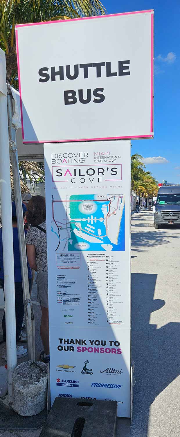
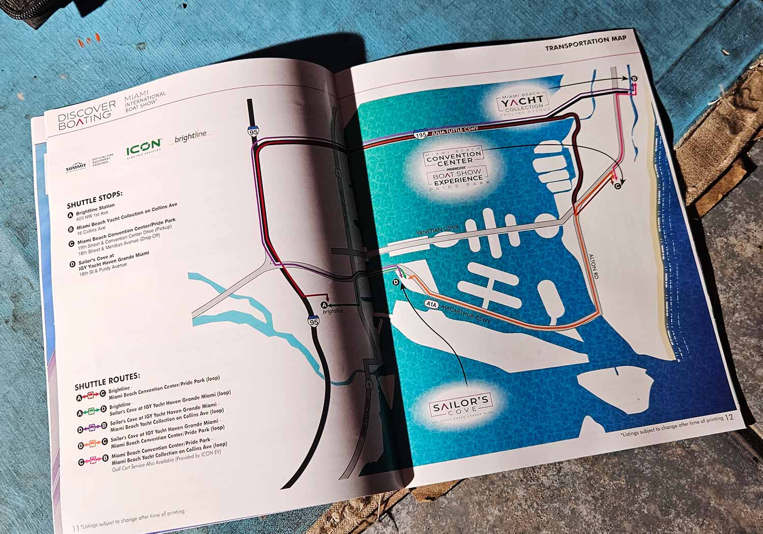
I produced the 2026 Miami International Boat Show Transportation Map in three coordinated versions. The printed map appears in the official show program and on on site signage, and it shares core content with the others, though I reformatted it for those specific uses. The web version includes expanded parking information so visitors can plan ahead before they arrive. Every version relies on a clean overhead view built from accurate geographic data. People can judge distances, trace routes, and understand how the venues relate to one another at a true and reliable scale.

Smarter Workflow, Better Consistency
I paid close attention to visual and informational continuity across all three formats this year. Shuttle routes and shuttle stop listings now live as shared source files that link directly to each map version. When I make an update, the change flows automatically to every output. Even the illustrated components, which I kept intentionally restrained here, are managed as linked assets. I have refined this workflow approach over several years, and it continues to pay off. Production time drops. Errors nearly disappear. Consistency becomes automatic rather than aspirational. At the same time, the maps stay flexible enough to absorb late breaking event changes. Continual refinement of how I work is not a side project. It is central to how I deliver clear, dependable mapping solutions for large scale public events.
One Show, Four Venues, Many Formats
The 2026 show spans four primary venues. I produced a dedicated map for each location, addressing the unique layout and visitor needs of every site. I also designed this comprehensive transportation map with its three tailored versions. On top of that, I developed a vertical format map of the Miami Beach Yacht Collection along Collins Avenue specifically for large scale signage. The same visual language carries across every piece, but I adjusted each one for different viewing distances, physical environments, and format constraints.
Maps That Earn Their Place
Large public events depend on clear, well organized maps. Visitors need to move efficiently between exhibits, displays, and amenities, and a confusing map undermines everything else. Beyond basic wayfinding, thoughtfully designed event maps also carry brand weight. They contribute to marketing efforts and shape the overall perception of quality. I invite you to explore the rest of my portfolio for more examples of illustrated maps and custom visual solutions created for complex venues and high traffic events.
Miami International Boat Show Maps 2026:
Miami Beach Yacht Collection on Collins Ave | Yacht Haven Grande Miami | Miami Beach Convention Center Map | Transportation Map | Pride Park MapEXAMPLES OF MAPS CREATED FOR MIAMI BOAT SHOWS:


Maps For Boat Shows In Miami:
- About Miami Boat Shows
- Miami International Boat Show / Miami Yacht Show / Yachts Miami Beach / Miami Beach Yacht and Brokerage Show - Show Center/Primary Venue Maps: 2026 | 2025 | 2024 | 2023 | 2022 | 2020 | 2019 | 2018 | 2017 | 2016 | 2015 | 2014 | 2013 | 2012 | 2011
- Transportation Map: 2026 | 2025 | 2024 | 2023 | 2022 | 2020 | 2019 | 2016 | 2013 | 2012
- Program Layout: 2026 | 2025 | 2024 | 2023 | 2022
- Yacht Haven Grande at Island Gardens: 2026 | 2022 | 2020 | 2016
- Miami Beach Convention Center: 2026 | 2025 | 2024 | 2023 | 2022 | 2013 | 2012
- Sea Isle Marina Only: 2013 | 2012
- Miamarina at Bayside Only: 2013 | 2012 | 2011
- Bayfront Park: 2015
- Museum Park Marina: 2025 | 2024 | 2023 | 2022
- Illustration (not a map): 2014
- Video: 2013
BROWSE MY WORK
- Illustration: Browse custom illustrations, book cover art, illustrated maps, and architectural renderings.
- Fine art: View original paintings and drawings, the Custom Halftone Series, and mural commissions.
- Graphic design & motion: See design projects, then watch motion reels and animated pieces.
- Maps by use case: Explore illustrated maps created for boat shows, resorts, marinas, real estate, transportation & parking, cities & towns, parks, and wayfinding.
- Specialty projects: Also check out cover design, vinyl & vehicle wraps, proposal renderings, and street art.
- Style & technique: Discover vector, isometric, painterly, monochrome, data-driven, bird's-eye, and halftone approaches.
- Tools I use: Everyday software includes Photoshop, Illustrator, SketchUp, and InDesign; motion work relies on Premiere & After Effects. Recently I have begun some work using AI as well.