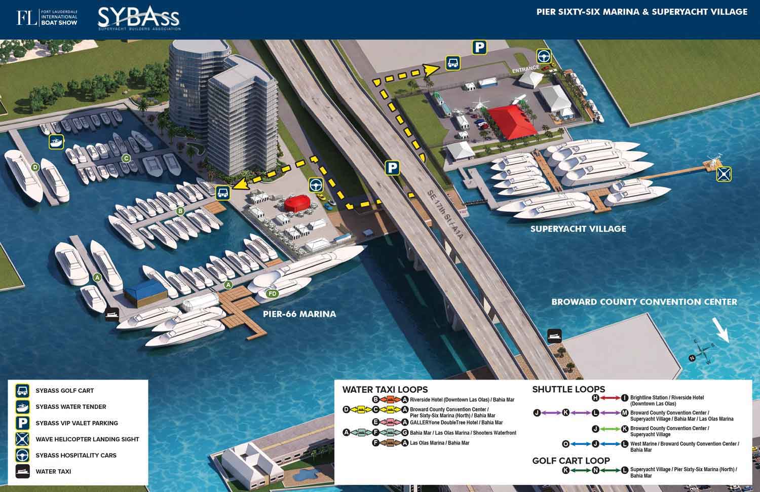
A custom illustrated map for SYBAss at the Fort Lauderdale International Boat Show
Client: SYBAss (Superyacht Builders Association)
For all the latest information on SYBAss please visit their site at SYBAss.org. If you are interested in hiring me to create an original map or illustration for you please contact me.
About This Map
Built upon a custom 3D digital model of Pier Sixty-Six Marina and Superyacht Village updated annually. This map highlights the specific SYBAss features at the Fort Lauderdale International Boat Show. By leveraging a 3D model, I can tailor angles, zoom levels, and perspectives that standard maps can't achieve. For this edition, I used AI alongside Photoshop and Illustrator to enhance materials, shading, and textures for a realistic finish.
Your Map
If you need a map for a boat show, an event, or any other venue that requires clear, detailed navigation, contact me to get started.
WORK FOR SYBAss (Superyacht Builders Association):


Fort Lauderdale International Boat Show Maps:
- About Fort Lauderdale International Boat Show
- Bahia Mar, Hall of Fame & Las Olas Marina Maps: 2026 | 2025 | 2024 | 2023 | 2022 | 2020 | 2019 | 2018 | 2017 | 2016 | 2015 | 2014 | 2013 | 2012 | 2011 | 2010
- Parking and Transportation Maps: 2026 | 2025 | 2024 | 2023 | 2022 | 2020 | 2019 | 2018 | 2015 Bus | 2015 Water Taxi | 2014 | 2013 | 2012 | 2011
- Broward County Convention Center Maps: 2026 | 2025 | 2024 | 2023 | 2022 | 2017 Sailfish Pavilion | 2017 | 2016 Sailfish Pavilion | 2016 | 2015 Sailfish Pavilion | 2015 | 2014 Sailfish Pavilion | 2014 | 2013 Sailfish Pavilion | 2013 | 2012 | 2011 | 2010
- 17th St Marinas Maps: 2026 | 2025 | 2024 | 2023 | 2022 | 2019 | 2016
- Show Directory Layouts: 2025 | 2024 | 2023 | 2022
- Video: 2013 54th Annual
- Illustrations (not maps): 2014A | 2014B


EXPLORE MY WORK
- Illustration: Discover custom illustrations, book covers, illustrated maps, and architectural renderings.
- Fine Art: Browse original paintings and drawings, view the Custom Halftone Series, or check out mural projects.
- Graphic Design & Motion: See the graphic design collection, then dive into motion design and animated illustrations.
- Maps by industry: View illustrated maps tailored for boat shows, resorts, marinas, real estate, transportation, towns, parks, and wayfinding.
- More project types: Explore cover art, vehicle wraps, proposal renderings, and street art.
- Techniques & styles: Work spans vector, isometric, painting, black-and-white, GeoData, overhead maps, and halftones.
- Software expertise: Primary tools include Photoshop, Illustrator, SketchUp Pro, and InDesign, plus Premiere Pro & After Effects for motion. I am also supplementing some projects with AI.
