Illustrated Boat Show Map Art
Client: Show Management
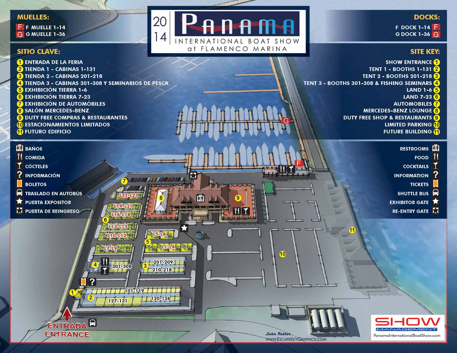
This project represents a significant milestone: my first international commission for a boat show. I was contracted by Show Management (now Informa Markets) to create the official illustrated map for the 2014 Panama International Boat Show.
The event was held at the scenic Flamenco Marina on Perico Island in Panama City. This location offered a distinctive setting, situated just past the Pacific entrance to the Panama Canal and connected to the mainland by the picturesque Amador Causeway. It is worth noting that this charming marina has since been redeveloped.
While the show itself was intimate in scale, with a balanced mix of exhibitors on land and in the water, the project demanded a thoughtful design solution. The venue's layout, which included substantial paved areas, presented a unique challenge. To address this, I developed a custom three dimensional digital model of the entire marina and its surroundings.
From this model, I rendered the map with a deliberate, sketch inspired aesthetic. This approach, reminiscent of an architectural illustration, elevated the visual appeal of the site. It allowed me to emphasize the beauty of the location and create a more engaging guide for attendees, transforming functional necessities into part of the art.
The map was designed for clarity and bilingual accessibility. All keying was presented in both English and Spanish. A clear system of color coded markers was implemented: red for dock letters and labels, yellow with numbers for points of interest. Amenities were indicated through an intuitive set of graphical icons, allowing for instant recognition without reliance on text although a key was supplied.
This illustrated map served as the official guide for the 2014 event, and I was pleased to revise and update it for the following year's show in 2015. This project remains a fond and foundational piece in my portfolio, showcasing the application of artistic vision to solve practical wayfinding challenges in a unique international setting.
Panama International Boat Show Map
BOAT SHOW MAPS ARTICLE - SOUTHERN BOATING MAGAZINE 2016:
"Navigating Miami’s multiple venues is easier when you use a map. If you’re at Yachts Miami Beach – formerly The Miami Yacht and Brokerage Show – the man behind those maps is John Potter of Escape Key Graphics, who created his first boat show map for the 201 Fort Lauderdale Int’l. Boat Show. It wasn't long before the creative concept spread. Less intimidating than site plans and more easier to follow than an aerial photography, Potter’s maps now grace the Stuart Boat Show, St. Petersburg Power & Sailboat Show in Florida and International Boat Shows like Newport, Palm Beach and Panama. His work on these shows frequently extends to many maps such as detailed area maps and transit maps. Potter’s maps can also be seen beyond the yachting industry in theme parks, resorts, wildlife sanctuaries, municipalities, campuses and gardens including Flamingo Gardens, Dinosaur World parks or The Dover International Speedway."
ADDENDUM:
I am presently responsible for illustrated maps for The Chicago International Boat Show, The Fort Lauderdale International Boat Show, The Miami International Boat Show, The Newport International Boat Show, The Newport Beach International Boat Show, The San Diego International Boat Show, The Windy City Boat & Yacht Show, The Palm Beach International Boat Show, The Suncoast Boat Show and the The Saint Petersburg Power and Sailboat Show.
There is a directory in my Boat Show Map Portfolio
CUSTOM BOAT SHOW MAPS:


