Suncoast Boat Show: Showcase for Custom Map Design
I have created illustrated maps for Suncoast boat shows since 2021, supporting events that serve both serious boaters and a broader regional audience along Florida's Gulf Coast. These shows are known for their welcoming atmosphere and strong connection to the local boating community, and my goal has been to reflect that character while delivering maps that are clear, accurate, and easy to use.
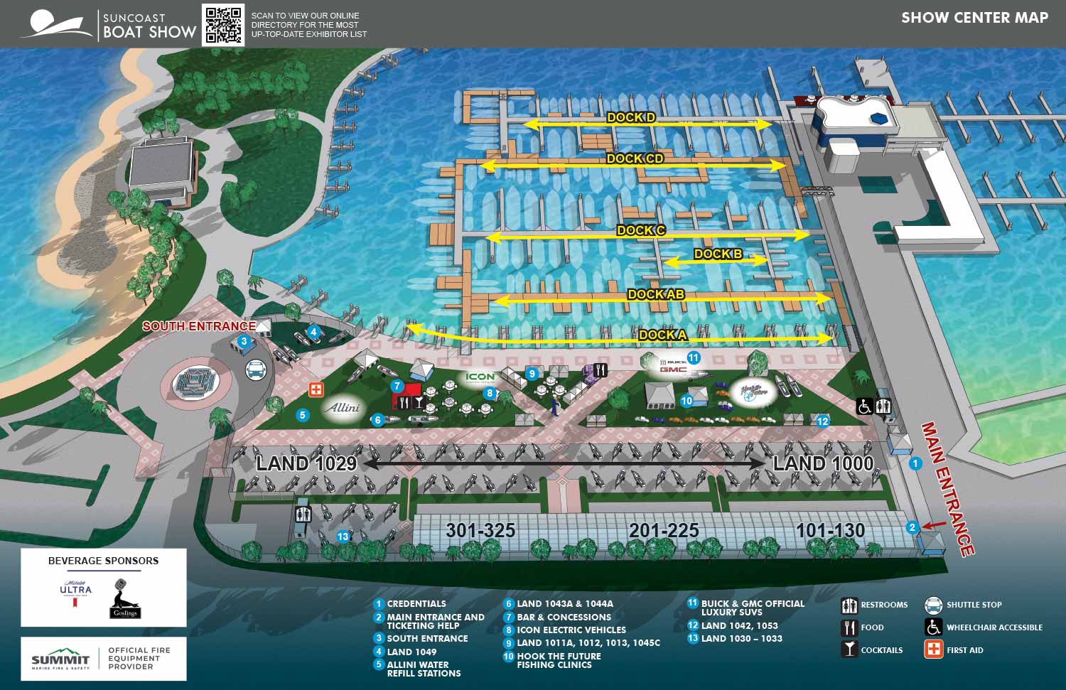
Suncoast boat shows typically combine enclosed exhibition spaces with outdoor display areas, parking, and surrounding amenities. This mix requires careful planning to help guests understand how the event is laid out before they arrive and navigate it while there. I focus on presenting the venue from an aerial view that allows visitors to quickly identify entrances, exhibitor zones, key attractions, and essential services. The result is a map that supports smooth movement through the show and reduces confusion during busy event days.
The map is designed to adapt across multiple formats, including printed show guides, signage, and digital use on websites and mobile devices. I rely on consistent visual systems such as numbered keying for primary destinations and icon based symbols for recurring amenities like restrooms, food areas, and information points. This approach keeps the map readable and efficient while allowing last minute updates without disrupting the overall design.
Boat shows benefit from maps that balance practical navigation with a clean, professional presentation. My experience illustrating marine events throughout the US (and some abroad) allows me to create maps that meet operational needs while reinforcing the branding and identity of the show. For event organizers and exhibitors, a well designed illustrated map becomes an important tool that improves the visitor experience and helps the show run smoothly from opening day to closing.
Find information about additional shows for Informa on my Informa Markets / Informa U.S. Boat Shows page.
MAPS FOR SUNCOAST BOAT SHOW:


BOAT SHOW MAPS ARTICLE - SOUTHERN BOATING MAGAZINE 2016:
"Navigating Miami’s multiple venues is easier when you use a map. If you’re at Yachts Miami Beach – formerly The Miami Yacht and Brokerage Show – the man behind those maps is John Potter of Escape Key Graphics, who created his first boat show map for the 201 Fort Lauderdale Int’l. Boat Show. It wasn't long before the creative concept spread. Less intimidating than site plans and more easier to follow than an aerial photography, Potter’s maps now grace the Stuart Boat Show, St. Petersburg Power & Sailboat Show in Florida and International Boat Shows like Newport, Palm Beach and Panama. His work on these shows frequently extends to many maps such as detailed area maps and transit maps. Potter’s maps can also be seen beyond the yachting industry in theme parks, resorts, wildlife sanctuaries, municipalities, campuses and gardens including Flamingo Gardens, Dinosaur World parks or The Dover International Speedway."
ADDENDUM:
I am presently responsible for illustrated maps for The Chicago International Boat Show, The Fort Lauderdale International Boat Show, The Miami International Boat Show, The Newport International Boat Show, The Newport Beach International Boat Show, The San Diego International Boat Show, The Windy City Boat & Yacht Show, The Palm Beach International Boat Show, The Suncoast Boat Show and the The Saint Petersburg Power and Sailboat Show.
There is a directory in my Boat Show Map Portfolio
PORTFOLIOS
- Illustration Portfolio: Start here for custom illustration and book covers. You can also browse illustrated maps and architectural rendering.
- Fine Art: I offer original paintings and drawings, including my Custom Halftone Series. You will also find mural work here.
- Graphic Design & Motion: View my graphic design portfolio. After that, explore motion design and animated illustrations.
- Maps by application: I create illustrated maps for boat shows, resorts, marinas, real estate, transportation, transit and parking, towns and cities, parks, and wayfinding.
- Additional project types: I also produce cover illustration, vehicle and vinyl wraps, proposal renderings, and street art.
- Illustration methods: My techniques include vector, isometric and axonometric, painting, black and white, GeoData maps, overhead maps, and custom halftones.
- Software portfolios: I work primarily in Adobe Photoshop, Adobe Illustrator, SketchUp Pro, and Adobe InDesign. For motion projects, I use Premiere Pro and After Effects.