Illustrated Map for the Suncoast Boat Show in Sarasota, Florida
Client: Informa Markets
I am the illustrator and designer of this map. If you want the latest and most accurate information about attending the Suncoast Boat Show please visit their official site at SuncoastBoatShow.com
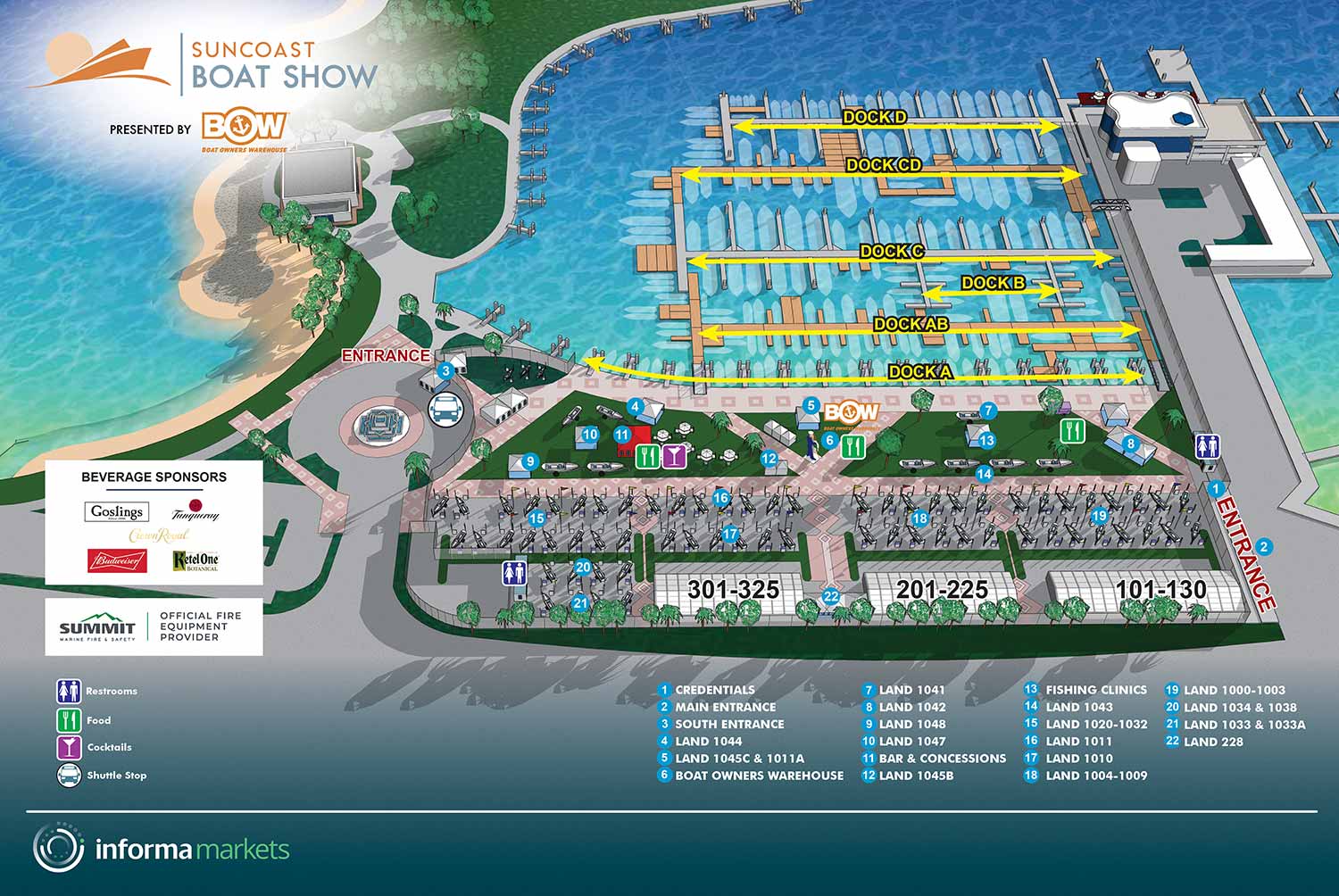
This project marks my third year creating the map for this show, and it remains a thoroughly enjoyable process. The 2023 Suncoast Boat Show featured more substantial changes to the floating dock arrangements than the previous year. These layout updates were supplied to me by the client in the form of a CAD plan. Several alterations were also made to the land based exhibit spaces.
On the graphic design side, a few refinements were implemented. The solid box previously placed behind the main logo was replaced with a circular fade from white to transparency. This treatment was gradually becoming the standard for integrating logos onto illustrations across Informa's portfolio of boat shows. The white background behind the graphical icons for features and amenities was removed, and the accompanying text was reversed to maintain legibility. New white boxes were introduced above this area to cleanly display sponsor logos. The keying system for points of interest remained consistent, using white numbers on blue dots, though the corresponding text listings were updated as usual.
The base illustration, as always, was generated from the three dimensional digital model I built for this venue years ago. The model continues to perform perfectly, requiring updates only to the specific features of the show itself. The established workflow is solid, and the lack of requests for major revision is a testament to an efficient and effective foundational design.
For any live event, last minute changes are a reality, particularly those involving exhibitors and sponsors. These can present a significant challenge. Only a seasoned professional can ensure an accurate and timely turnaround while coordinating updates across numerous files in multiple software packages.
Maps of this kind are exceptional marketing tools. The fact that the show has not yet opened does not prevent potential attendees from gaining a clear sense of what to expect, from the number of exhibitors to the accessibility of restrooms. This is marketing that truly informs, rather than simply aiming to dazzle. This strategic value is why Informa publishes these maps on their websites well in advance of the event. When the show arrives, the same visual asset is repurposed for printed handouts, mobile applications, and onsite signage. This represents substantial utility and return from a single, well crafted visual product.
For more examples of my illustrative cartography, please visit my Maps Portfolio.
MAPS FOR SUNCOAST BOAT SHOW:


PORTFOLIOS
- Illustration Portfolio: Start here for custom illustration and book covers. You can also browse illustrated maps and architectural rendering.
- Fine Art: I offer original paintings and drawings, including my Custom Halftone Series. You will also find mural work here.
- Graphic Design & Motion: View my graphic design portfolio. After that, explore motion design and animated illustrations.
- Maps by application: I create illustrated maps for boat shows, resorts, marinas, real estate, transportation, transit and parking, towns and cities, parks, and wayfinding.
- Additional project types: I also produce cover illustration, vehicle and vinyl wraps, proposal renderings, and street art.
- Illustration methods: My techniques include vector, isometric and axonometric, painting, black and white, GeoData maps, overhead maps, and custom halftones.
- Software portfolios: I work primarily in Adobe Photoshop, Adobe Illustrator, SketchUp Pro, and Adobe InDesign. For motion projects, I use Premiere Pro and After Effects.