Boat Show Picture Map
Client: Show Management
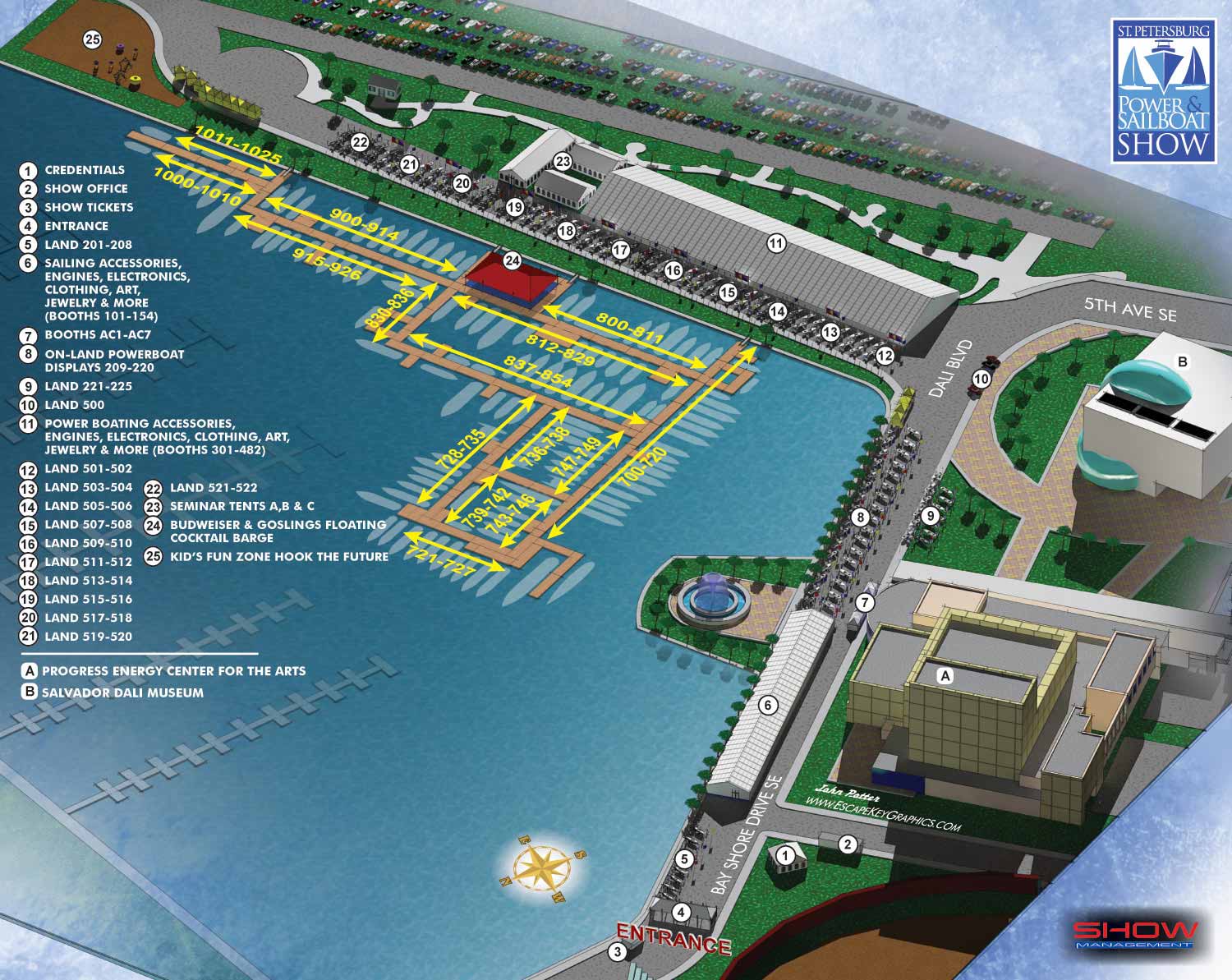
For the 2013 edition of the St. Petersburg Power and Sailboat Show map, I introduced a distinct artistic evolution, refining the visual language while maintaining the robust informational framework established in previous years. This iteration focused on enhancing clarity and adopting a more expressive, handcrafted aesthetic, all built upon the versatile digital 3D model created for the 2012 map.
The most immediate change was a shift to a steeper aerial viewpoint. This adjustment provided a more comprehensive overview of the show's footprint in Albert Whitted Park and along Bayshore Drive SE. More significantly, I applied new texturing and post processing techniques to give the rendering a unique character. The final artwork features more pronounced, sketch like line work and a subtle grainy texture that evokes the feel of traditional watercolor or ink. This demonstrated how a single digital model could be adapted to produce fresh visual styles year over year.
Key navigational elements were also refined for optimal legibility. Points of interest within the show were now marked with black numbers on white dots, maximizing contrast and visibility. To clearly distinguish them from exhibitor locations, the primary landmarks, the iconic Dalí Museum and the Duke Energy Center for the Arts, were labeled with letters. A pivotal change was the transition from detailed 3D boat models to simplified silhouettes within the marina. This intentional shift helped communicate that these vessels were representative placeholders, not literal depictions of specific boats or locations, ensuring the map was read as a guide rather than a photorealistic snapshot.
The practical keying system for dock exhibitors, using numbered spans (e.g., 830-836), remained consistent for attendee familiarity. However, the enlarged inset map of the largest exhibitor tent was integrated directly into the main key this year, streamlining the layout while retaining all essential information.
This map was crafted using a consistent digital toolkit: SketchUp Pro for modeling, Kerkythea for rendering, with final composition and detailing completed in Adobe Photoshop and graphics and menu creation in Illustrator. The 2013 version stands as a purposeful step in the series, balancing artistic experimentation with a continued commitment to creating an effective and elegant wayfinding tool for one of Florida's premier marine events.
St. Petersburg Power & Sailboat Show Maps
- About St. Petersburg Power & Sailboat Show
- 2026 | 2025 | 2024 | 2023 | 2022 | 2021 | 2019 | 2018 | 2017 | 2016 | 2015 | 2014 | 2013 | 2012 | 2011


PORTFOLIOS
- Illustration Portfolio: Start here for custom illustration and book covers. You can also browse illustrated maps and architectural rendering.
- Fine Art: I offer original paintings and drawings, including my Custom Halftone Series. You will also find mural work here.
- Graphic Design & Motion: View my graphic design portfolio. After that, explore motion design and animated illustrations.
- Maps by application: I create illustrated maps for boat shows, resorts, marinas, real estate, transportation, transit and parking, towns and cities, parks, and wayfinding.
- Additional project types: I also produce cover illustration, vehicle and vinyl wraps, proposal renderings, and street art.
- Illustration methods: My techniques include vector, isometric and axonometric, painting, black and white, GeoData maps, overhead maps, and custom halftones.
- Software portfolios: I work primarily in Adobe Photoshop, Adobe Illustrator, SketchUp Pro, and Adobe InDesign. For motion projects, I use Premiere Pro and After Effects.