
FLIBS 2018 Parking and Transit Map
Client: Informa Markets
For more (and more up to date) information about the 2018 Fort Lauderdale International Boat Show visit their official site at FLIBS.com.
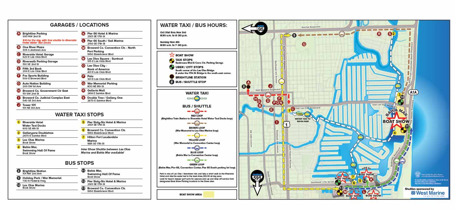
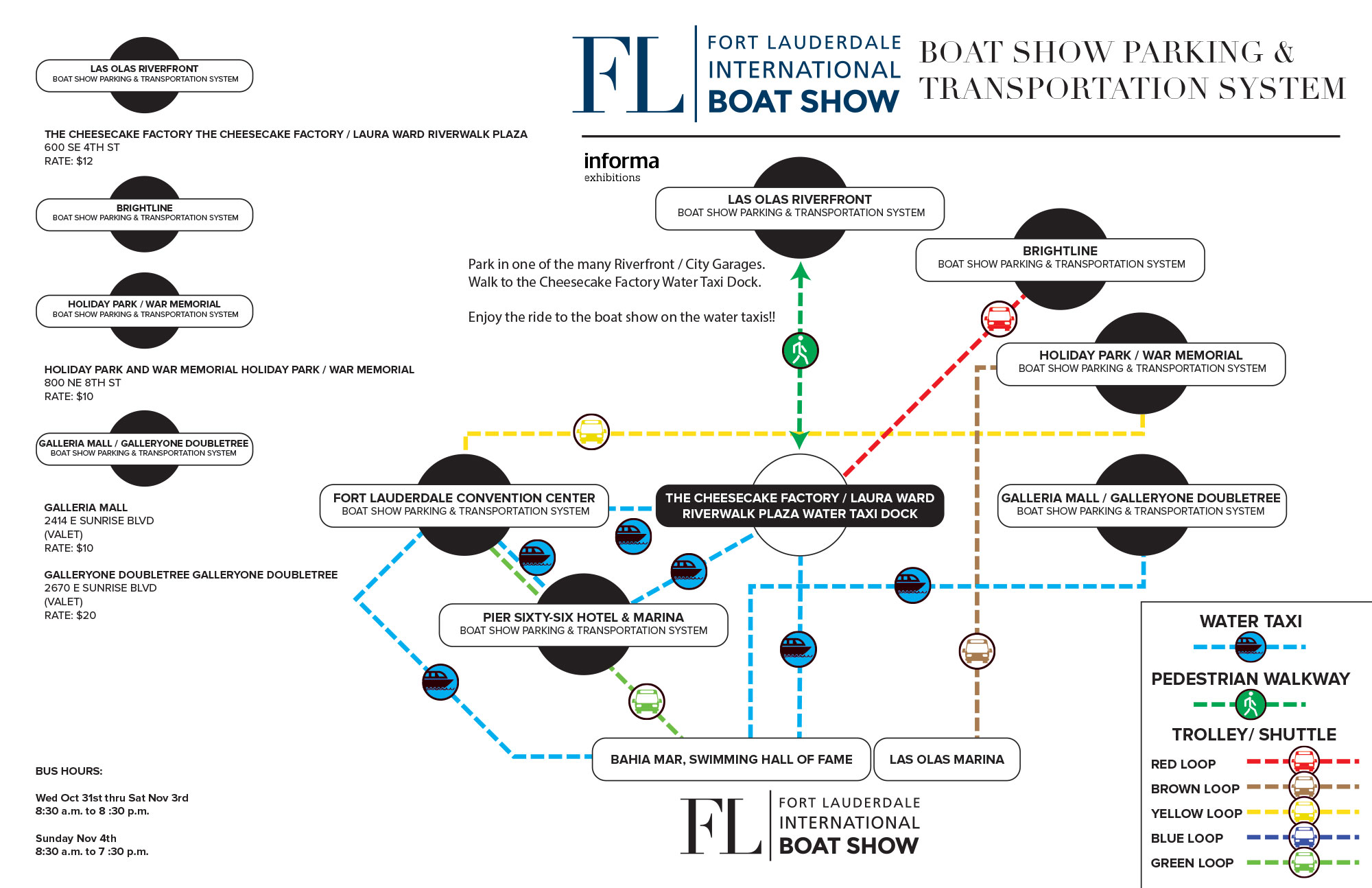
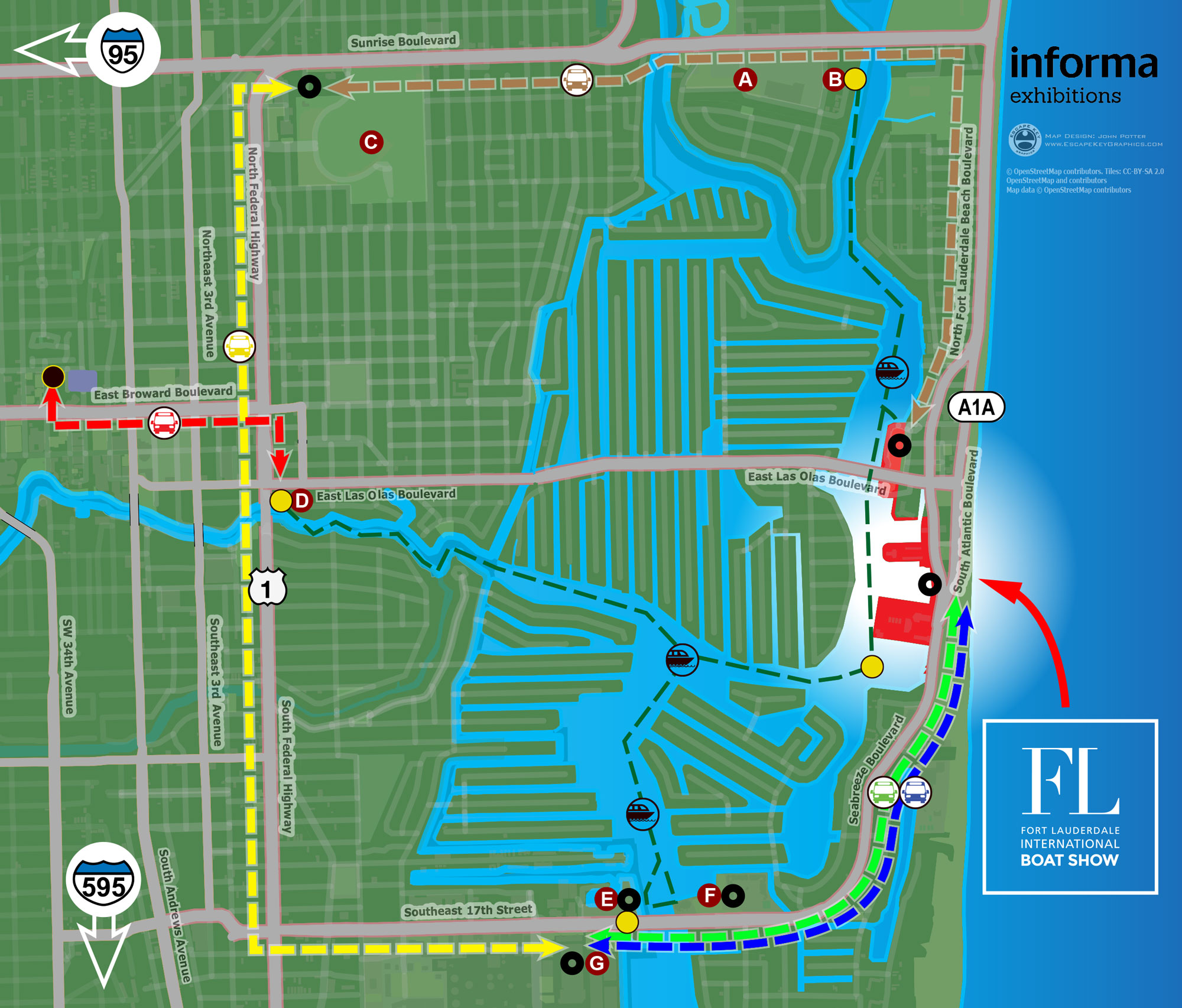
The 2018 Fort Lauderdale International Boat Show marked a transition in the approach to its transportation and parking map. This year, I collaborated with a different manager at Informa than in prior years. This manager was open to reevaluating the existing format. While previous editions of the map had prioritized a stylized, illustrative approach, there was a shared interest in shifting towards a design that emphasized clear information delivery. This led to the decision to adopt an overhead map format built upon open source geographic data, representing a step toward a more grounded and practical foundation.
The new direction, however, introduced its own set of design challenges. In moving away from a simpler illustration, the map quickly incorporated a high density of information. The client requested specific graphical treatments, such as using red stars to denote venues, which I felt impacted the overall aesthetic refinement. The map aimed to consolidate numerous elements: all parking locations were marked with keyed maroon dots, water taxi stops with numbered yellow dots, and bus stops with black dots. The routes for water taxis and buses were indicated with colored paths and accompanying icons, a combination that contributed to a visually busy composition. While it presented a broad overview of parking areas locations, it showed general locations without providing specific routing details, limiting its utility for precise trip planning.
This 2018 map represents an important, albeit complex, evolutionary step. The core decision to use vector based geographic data established a durable technical foundation that I continue to build upon today. The process for this edition involved creating and reviewing multiple versions, including a purely diagrammatic option, before arriving at the published design. In retrospect, the project faced significant challenges in balancing stakeholder input with optimal design principles. A more streamlined collaborative process, with greater autonomy in graphical decision making, would have likely yielded a more immediately effective result. The years following this edition saw continued refinement, ultimately leading to the clearer, more focused transit guides used today, which benefit from the lessons learned during this transitional period.
For more examples of my current approach to clear, user focused event transportation graphics, please see the 2025 version.
MAPS FOR BOAT SHOWS IN FORT LAUDERDALE:


Fort Lauderdale International Boat Show Maps:
- About Fort Lauderdale International Boat Show
- Bahia Mar, Swimming Hall of Fame & Las Olas Marina Maps: 2025 | 2024 | 2023 | 2022 | 2020 | 2019 | 2018 | 2017 | 2016 | 2015 | 2014 | 2013 | 2012 | 2011 | 2010
- Parking and Transportation Maps: 2025 | 2024 | 2023 | 2022 | 2020 | 2019 | 2018 | 2015 Bus | 2015 Water Taxi | 2014 | 2013 | 2012 | 2011
- Broward County Convention Center Maps: 2025 | 2024 | 2023 | 2022 | 2017 Sailfish Pavilion | 2017 | 2016 Sailfish Pavilion | 2016 | 2015 Sailfish Pavilion | 2015 | 2014 Sailfish Pavilion | 2014 | 2013 Sailfish Pavilion | 2013 | 2012 | 2011 | 2010
- Marinas Maps: 2025 | 2024 | 2023 | 2022 | 2019 | 2016
- Program Layouts: 2025 | 2024 | 2023 | 2022
- Signs: 2013 looking north | 2013 Yachting Tent
- Video: 2013 54th Annual
- Illustrations (not maps): 2014A | 2014B


PORTFOLIOS
- Illustration Portfolio: Start here for custom illustration and book covers. You can also browse illustrated maps and architectural rendering.
- Fine Art: I offer original paintings and drawings, including my Custom Halftone Series. You will also find mural work here.
- Graphic Design & Motion: View my graphic design portfolio. After that, explore motion design and animated illustrations.
- Maps by application: I create illustrated maps for boat shows, resorts, marinas, real estate, transportation, transit and parking, towns and cities, parks, and wayfinding.
- Additional project types: I also produce cover illustration, vehicle and vinyl wraps, proposal renderings, and street art.
- Illustration methods: My techniques include vector, isometric and axonometric, painting, black and white, GeoData maps, overhead maps, and custom halftones.
- Software portfolios: I work primarily in Adobe Photoshop, Adobe Illustrator, SketchUp Pro, and Adobe InDesign. For motion projects, I use Premiere Pro and After Effects.