Saint Petersburg Power & Sailboat Show Map, 2017
Client: Informa Markets
For information on attending the Saint Petersburg Power and Sailboat Show please visit StPeteBoatShow.com
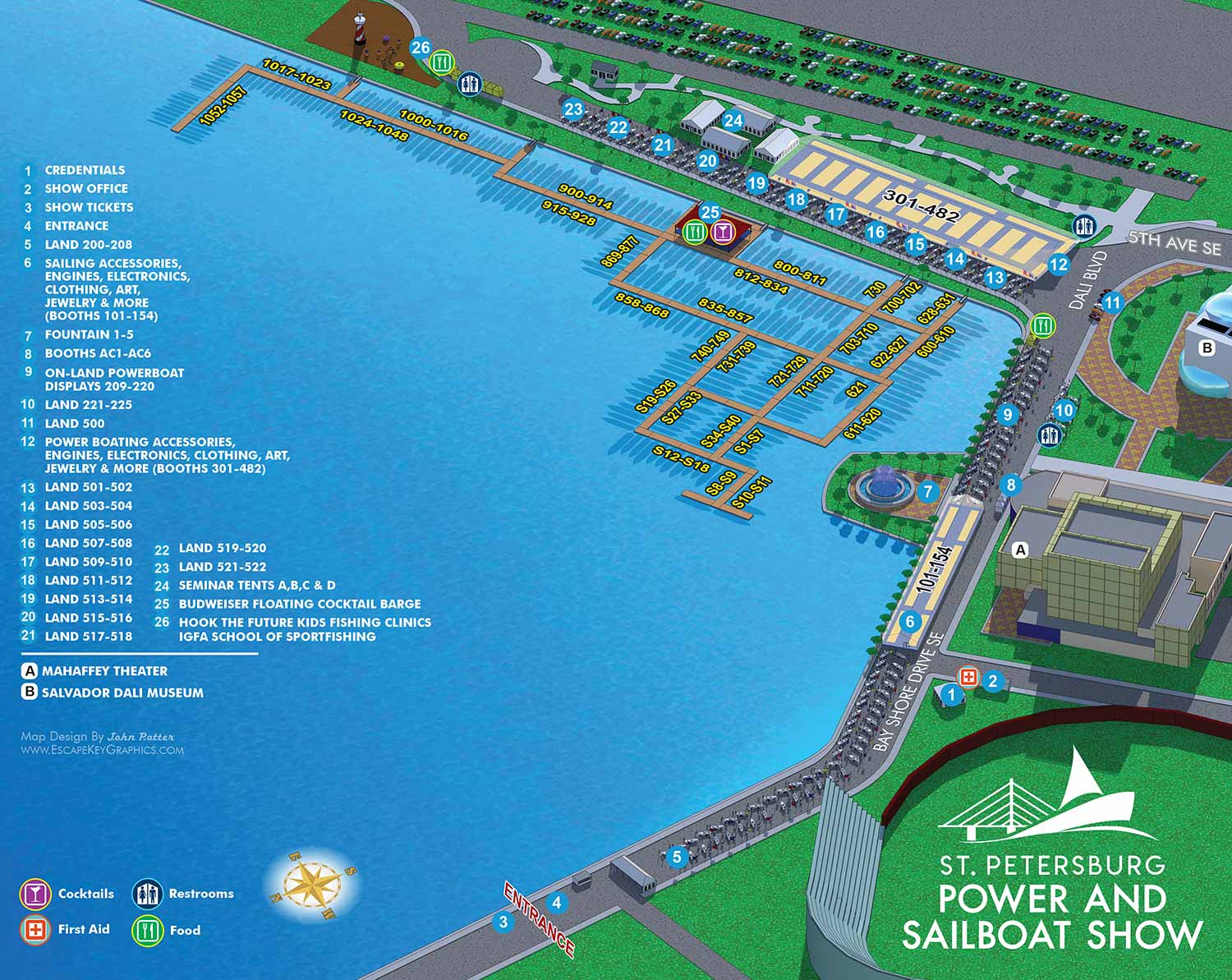
The 2017 Saint Petersburg Power and Sailboat Show map required only minor alterations from the previous year, a strong indication that the 2016 design provided a solid and effective foundation.
Illustration Revisions
Several refinements were made to the illustrative view. The permanent docks located directly across from the main floating display docks were omitted, as they were not relevant to the show layout. I also discontinued the subtle fuzzy outline effect experimented with the previous year. While it was not disruptive, removing it adhered to a principle of pragmatic simplicity. The overall magnification of the view increased slightly, and the perspective panned to the left. This adjustment resulted in less of the nearby Dali Museum being visible, a deliberate choice to reduce extraneous visual information and focus the viewer's attention on the active show areas. As always, the bulk of the illustrative work involved updating the three dimensional digital model to reflect the current year's floating dock configurations and land display arrangements. This updated model was then rendered and the resulting image files were refined in Adobe Photoshop.
Graphic Design Updates
The event featured a new, cleaner, and more contemporary logo, a welcome update courtesy of another designer. A significant change to the information design involved the two main exhibitor tents. Previously, each tent displayed multiple number spans corresponding to specific booth footprints. In 2017, this was simplified to a single number span for the entire tent. While not my decision, I consider it a sound one. This approach makes the map more resilient to last minute exhibitor changes, as interior booth shuffles do not affect the labeling. Since individual booths inside the tents were never visibly numbered on site, the single span provided sufficient information for attendees to know if a specific exhibitor was located within that tent, encouraging exploration and incidental discovery.
The established keying system was retained. Points of interest continued to be marked with white numerals on blue dots, and the set of graphical icons for amenities was updated. The separate key identifying nearby buildings remained unchanged from the previous year.
For more examples of my illustrative cartography for marine events, please visit my Maps Portfolio.
St. Petersburg Power & Sailboat Show Maps
- About St. Petersburg Power & Sailboat Show
- 2026 | 2025 | 2024 | 2023 | 2022 | 2021 | 2019 | 2018 | 2017 | 2016 | 2015 | 2014 | 2013 | 2012 | 2011
MARINA MAPS:


CUSTOM BOAT SHOW MAPS:


PORTFOLIOS
- Illustration Portfolio: Start here for custom illustration and book covers. You can also browse illustrated maps and architectural rendering.
- Fine Art: I offer original paintings and drawings, including my Custom Halftone Series. You will also find mural work here.
- Graphic Design & Motion: View my graphic design portfolio. After that, explore motion design and animated illustrations.
- Maps by application: I create illustrated maps for boat shows, resorts, marinas, real estate, transportation, transit and parking, towns and cities, parks, and wayfinding.
- Additional project types: I also produce cover illustration, vehicle and vinyl wraps, proposal renderings, and street art.
- Illustration methods: My techniques include vector, isometric and axonometric, painting, black and white, GeoData maps, overhead maps, and custom halftones.
- Software portfolios: I work primarily in Adobe Photoshop, Adobe Illustrator, SketchUp Pro, and Adobe InDesign. For motion projects, I use Premiere Pro and After Effects. You can watch my demo reel here.