
Fort Lauderdale International Boat Show 2019 - Parking and Transit Map
Client: Informa Markets
For more (and more up to date) information about the 2019 Fort Lauderdale International Boat Show visit their official site at FLIBS.com.
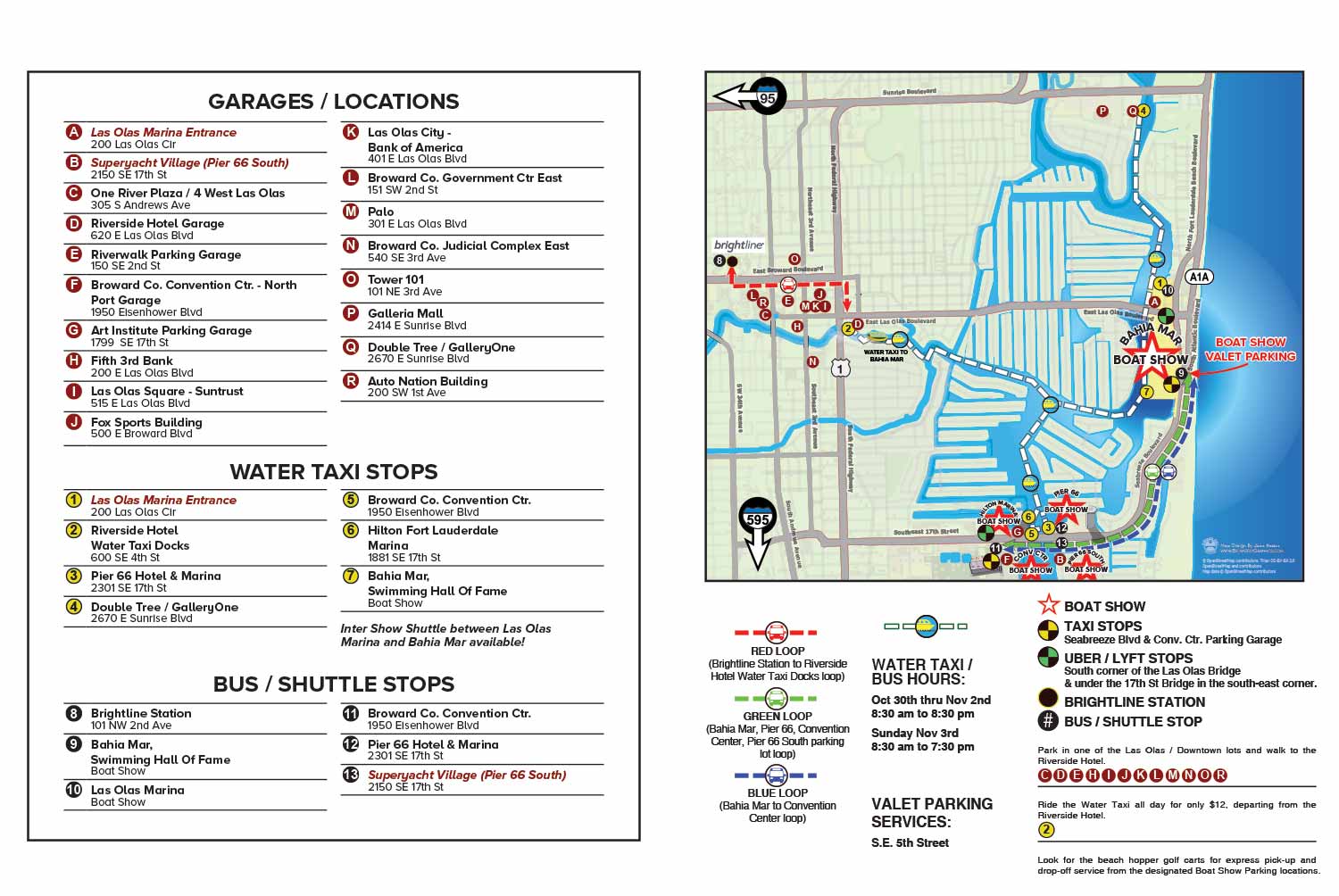
The 2019 edition of the Fort Lauderdale International Boat Show parking and transit map was produced as an update to the existing design rather than a significant evolution. The focus for this year was on maintaining consistency and implementing the necessary annual revisions to information.
The map continued the established approach of consolidating a wide range of logistical information into a single overview. This included marking all parking locations with keyed maroon dots, identifying water taxi stops with numbered yellow dots, and denoting bus stops with black dots. The routes for both water taxis and buses were illustrated with colored paths and accompanied by matching icons, a design choice that contributed to the map's detailed and information dense composition.
For those following the developmental narrative of this particular map series, the next notable phase of redesign and conceptual refinement began with the 2020 edition.
MAPS FOR BOAT SHOWS IN FORT LAUDERDALE:


Fort Lauderdale International Boat Show Maps:
- About Fort Lauderdale International Boat Show
- Bahia Mar, Swimming Hall of Fame & Las Olas Marina Maps: 2025 | 2024 | 2023 | 2022 | 2020 | 2019 | 2018 | 2017 | 2016 | 2015 | 2014 | 2013 | 2012 | 2011 | 2010
- Parking and Transportation Maps: 2026 | 2025 | 2024 | 2023 | 2022 | 2020 | 2019 | 2018 | 2015 Bus | 2015 Water Taxi | 2014 | 2013 | 2012 | 2011
- Broward County Convention Center Maps: 2026 | 2025 | 2024 | 2023 | 2022 | 2017 Sailfish Pavilion | 2017 | 2016 Sailfish Pavilion | 2016 | 2015 Sailfish Pavilion | 2015 | 2014 Sailfish Pavilion | 2014 | 2013 Sailfish Pavilion | 2013 | 2012 | 2011 | 2010
- 17th St Marinas Maps: 2026 | 2025 | 2024 | 2023 | 2022 | 2019 | 2016
- Show Directory Layouts: 2025 | 2024 | 2023 | 2022
- Video: 2013 54th Annual
- Illustrations (not maps): 2014A | 2014B


BROWSE MY WORK
- Illustration: Browse custom illustrations, book cover art, illustrated maps, and architectural renderings.
- Fine art: View original paintings and drawings, the Custom Halftone Series, and mural commissions.
- Graphic design & motion: See design projects, then watch motion reels and animated pieces.
- Maps by use case: Explore illustrated maps created for boat shows, resorts, marinas, real estate, transportation & parking, cities & towns, parks, and wayfinding.
- Specialty projects: Also check out cover design, vinyl & vehicle wraps, proposal renderings, and street art.
- Style & technique: Discover vector, isometric, painterly, monochrome, data-driven, bird's-eye, and halftone approaches.
- Tools I use: Everyday software includes Photoshop, Illustrator, SketchUp, and InDesign; motion work relies on Premiere & After Effects. Recently I have begun some work using AI as well.