
Fort Lauderdale International Boat Show 2026- Parking and Transportation Map
Client: Informa Markets
For more (and more up to date) information about the 2026 Fort Lauderdale International Boat Show visit their official site at FLIBS.com.
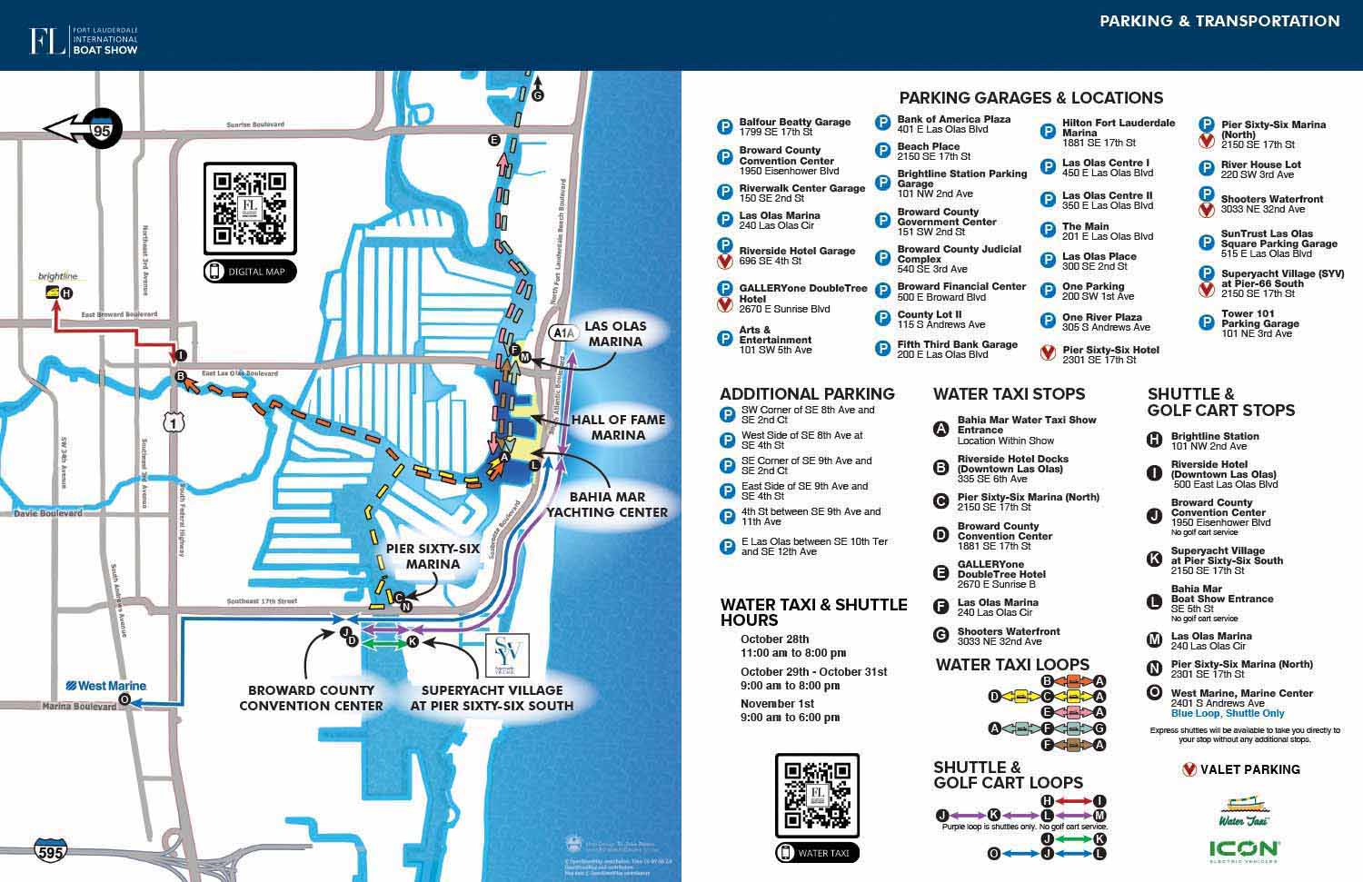
The Fort Lauderdale International Boat Show spreads across several miles, multiple docks, and major venues throughout the city. For 2026, the map design keeps the effective two page layout from past years while improving visual clarity for anyone reading the printed program or the digital PDF at FLIBS.com.
The main map relies on an overhead flat projection built from open source geographic data via OpenStreetMap. Beginning with accurate GIS vectors means every street intersection, bridge, and harbor channel matches the real world. The base geometry was simplified by removing secondary neighborhoods and minor side streets so visitors can focus on primary roads like Seabreeze Boulevard, 17th Street, and Sunrise Boulevard.
Fort Lauderdale's coastline and waterways act as natural reference points on the page. By contrasting land areas against detailed water features, the map helps people orient themselves relative to the Atlantic Ocean and the Intracoastal Waterway. All core show sites, such as Bahia Mar Yachting Center, Las Olas Marina, Hall of Fame Marina, Pier 66, SuperYacht Village, and the Broward County Convention Center, appear with custom venue labels.
Transit options are shown as separate colored vector paths. Water taxi routes appear as bold dashed lines that follow real navigational channels. Shuttle and golf cart routes use solid colored lines aligned with the city street grid. Transit hubs and pick-up points are marked with lettered icons that connect to the companion key on the next page.
The right side of the spread serves as a directory for parking, water taxi stops, shuttle drop-offs, and golf cart loops. Keeping the text heavy directory separate from the main geographical view preserves a clean, readable layout.
Each parking lot and garage listing includes a precise street address. Drivers can type destinations straight into mobile apps like Google Maps or Apple Maps before leaving. Parking icons also distinguish standard self-parking facilities from locations with valet service.
A schematic diagram inside the transit key helps visitors plan movement across the event. This diagram uses a simplified, topological structure inspired by classic transit maps such as Harry Beck's London Underground design. Instead of showing exact geography, the secondary graphic focuses on connections, transfer points, and sequential stops along each shuttle or water taxi line. Attendees can quickly check whether a specific loop connects their current location directly to their next destination.
Fort Lauderdale International Boat Show Maps 2026:
Parking and Transportation Map | Marinas (17th St Cswy) Map | Broward County Convention Center MapMAPS FOR BOAT SHOWS IN FORT LAUDERDALE:


Fort Lauderdale International Boat Show Maps:
- About Fort Lauderdale International Boat Show
- Bahia Mar, Swimming Hall of Fame & Las Olas Marina Maps: 2025 | 2024 | 2023 | 2022 | 2020 | 2019 | 2018 | 2017 | 2016 | 2015 | 2014 | 2013 | 2012 | 2011 | 2010
- Parking and Transportation Maps: 2026 | 2025 | 2024 | 2023 | 2022 | 2020 | 2019 | 2018 | 2015 Bus | 2015 Water Taxi | 2014 | 2013 | 2012 | 2011
- Broward County Convention Center Maps: 2026 | 2025 | 2024 | 2023 | 2022 | 2017 Sailfish Pavilion | 2017 | 2016 Sailfish Pavilion | 2016 | 2015 Sailfish Pavilion | 2015 | 2014 Sailfish Pavilion | 2014 | 2013 Sailfish Pavilion | 2013 | 2012 | 2011 | 2010
- 17th St Marinas Maps: 2026 | 2025 | 2024 | 2023 | 2022 | 2019 | 2016
- Show Directory Layouts: 2025 | 2024 | 2023 | 2022
- Video: 2013 54th Annual
- Illustrations (not maps): 2014A | 2014B
PORTFOLIO GALLERIES
- Illustration work: Start with custom illustration and cover design, then view illustrated maps and architectural renderings.
- Fine art: Discover original paintings and drawings, the Custom Halftone Series, and mural projects.
- Design & motion: Check out the graphic design gallery, then move on to motion graphics and animated illustration.
- Maps by sector: I produce illustrated maps for boat shows, resorts, marinas, real estate, transit & parking, towns & cities, parks, and wayfinding systems.
- More creative services: Additional offerings include cover illustration, vehicle wraps, proposal renderings, and street art.
- Artistic methods: My work spans vector art, isometric & axonometric views, traditional painting, black & white illustration, GeoData mapping, overhead perspectives, and halftone effects. Recently I have also begun to utilize AI in some cases.
- Preferred software: I rely on Photoshop, Illustrator, SketchUp Pro, and InDesign, plus Premiere Pro & After Effects for motion projects.
