Illustrated Site Plan Map for Exhibitors
Client: Show Management
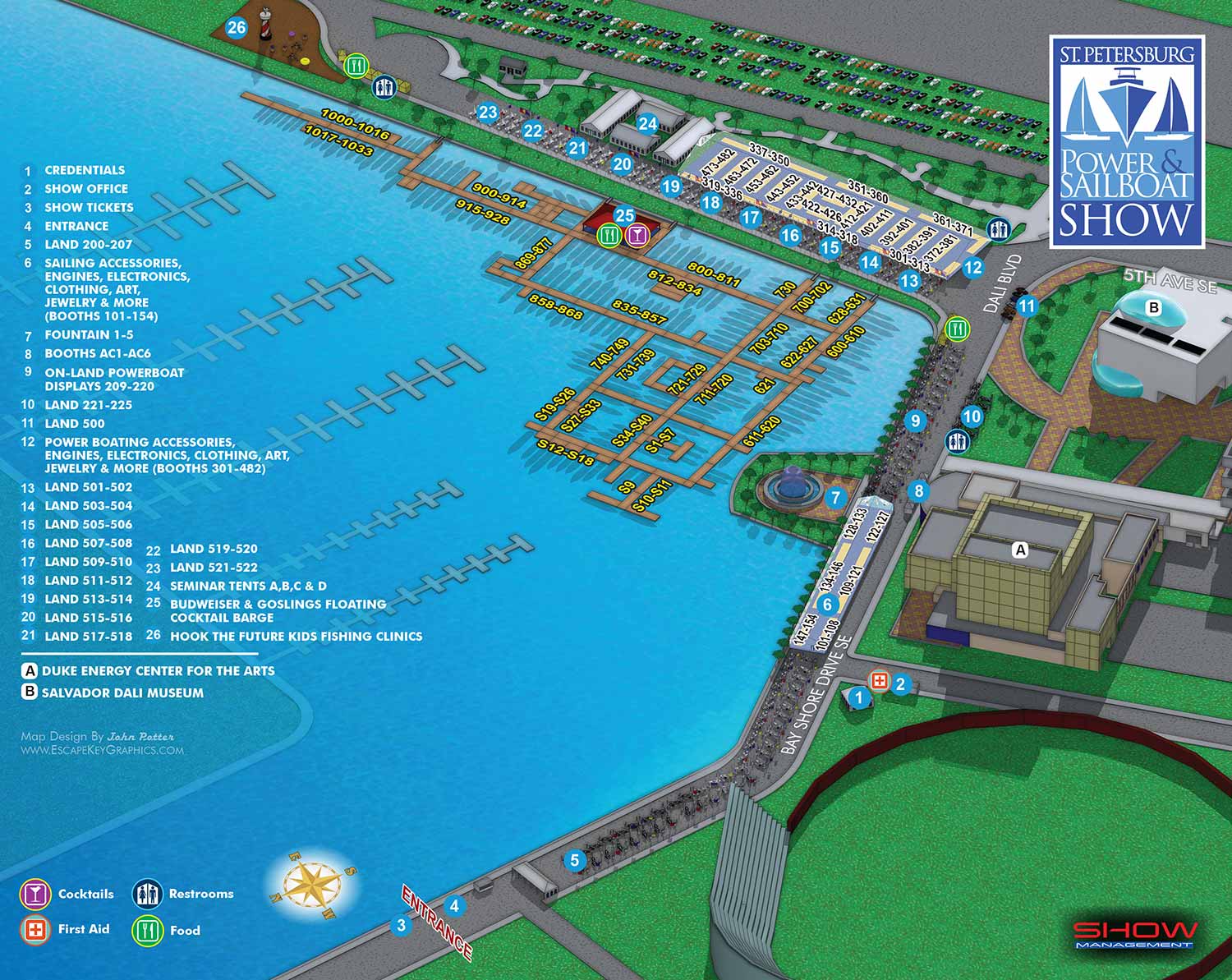
For this particular event, the client typically supplies either a CAD file of the venue layout or annotated notes. When provided with a CAD file, I conduct a thorough review to identify any discrepancies from the previous year's plan. For a smaller show with relatively few changes, the client may simply offer handwritten notes directly on a printed copy of the prior year's map. After implementing these updates to the base illustration, I require finalized text for any revisions to the map key and exhibitor number spans. These textual updates are sometimes delivered as simple annotations when the changes are minimal.
The marine event industry is inherently dynamic. Last minute adjustments are common, with new exhibitors confirming participation and sponsors revising plans close to the event date. It is standard practice for clients to include disclaimers on their materials noting that information is subject to change after printing or publication. This fluid working environment is a key reason many illustrators might hesitate to undertake such projects. Successfully creating accurate and timely boat show maps requires a graphic artist who is not only precise but also efficient and highly adaptable to evolving requirements.
For this map, I experimented with a soft outlined visual style intended to give the overall image a warmer, more approachable feeling. This was a minor stylistic exploration, and while I do not believe anyone specifically commented on it, it represents the kind of subtle refinement I consider in the design process.
The established keying method and numerical systems for identifying exhibitors remained consistent to ensure user familiarity. The necessary annual updates involved standard changes to floating dock configurations, boat silhouette placements, and minor adjustments to land based exhibit areas.
A minimal need for major structural redesign in any given year is typically a positive indicator of a solid, effective foundational design. Returning visitors generally appreciate the comfort and intuitive ease of a familiar layout. I maintain this continuity by using the same core three dimensional digital model as the foundation for the map each season. This systematic approach allows me to preserve the overall illustration style and user experience while efficiently updating only the specific elements that require revision.
Illustrated event maps fulfill a distinct and valuable role by enabling potential attendees to clearly visualize their experience before arrival. Rather than relying on generic stock photography, guests can examine an accurate and detailed representation of the actual event layout. These maps effectively communicate the event's scale and physical setting while delivering practical information about amenities, including restroom locations, food and beverage access, and transportation or parking options. As a result, illustrated maps function as both aesthetically pleasing graphics and genuinely useful informational and marketing resources.
For more examples of my illustrative cartography, please visit my Maps Portfolio.
St. Petersburg Power & Sailboat Show Maps
- About St. Petersburg Power & Sailboat Show
- 2026 | 2025 | 2024 | 2023 | 2022 | 2021 | 2019 | 2018 | 2017 | 2016 | 2015 | 2014 | 2013 | 2012 | 2011
MARINA MAPS:


CUSTOM BOAT SHOW MAPS:


PORTFOLIOS
- Illustration Portfolio: Start here for custom illustration and book covers. You can also browse illustrated maps and architectural rendering.
- Fine Art: I offer original paintings and drawings, including my Custom Halftone Series. You will also find mural work here.
- Graphic Design & Motion: View my graphic design portfolio. After that, explore motion design and animated illustrations.
- Maps by application: I create illustrated maps for boat shows, resorts, marinas, real estate, transportation, transit and parking, towns and cities, parks, and wayfinding.
- Additional project types: I also produce cover illustration, vehicle and vinyl wraps, proposal renderings, and street art.
- Illustration methods: My techniques include vector, isometric and axonometric, painting, black and white, GeoData maps, overhead maps, and custom halftones.
- Software portfolios: I work primarily in Adobe Photoshop, Adobe Illustrator, SketchUp Pro, and Adobe InDesign. For motion projects, I use Premiere Pro and After Effects. You can watch my demo reel here.