Map for the Palm Beach International Boat Show - 2020
Client: Informa Markets
NOTICE: The 2020 Palm Beach International Boat Show was postponed due to global health concerns.
For event information and all the latest maps please visit the official site of the boat show.
If you are interested in hiring me to create an original map or illustration for you please contact me.
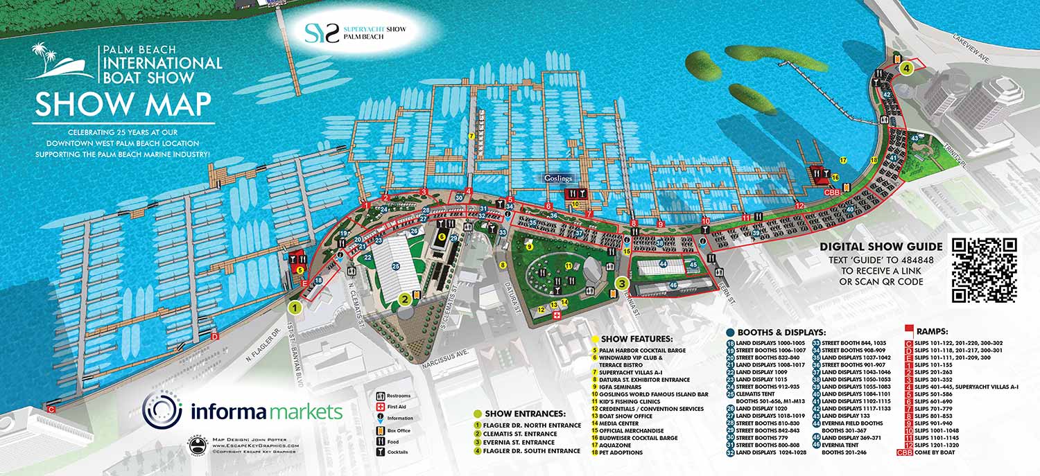
The 2020 Palm Beach International Boat Show, like many events that year, was ultimately canceled. The map represents the event as it was fully planned, a visualization of what could have been. According to my notes, I received the first updated CAD drawings from Informa on February twenty sixth. I compared these with the previous year's plans to identify discrepancies and began revising the placement of floating docks, exhibitor tents, and other elements.
A notable expansion planned for 2020 was the addition of dockage across the Intracoastal Waterway from the main show center, at the Henry Morrison Flagler Museum. Earlier versions of the map were close to included the near edge of the opposite shoreline, so incorporating this new area primarily required a slight zoom out. To accommodate this, I expanded the existing three dimensional digital model that serves as the foundational asset for my illustrations of this location. The map key system, using numbered and color coded dots, was revised but retained its established structure. The set of graphical icons for indicating amenities was also updated accordingly. Supplemental maps were also created for The Superyacht Show, to be held at Henry Morrison Flagler Museum, a transportation map and four tent detail maps for signage.
I received and incorporated additional revisions leading up to final approval on March ninth. Unfortunately, the show was postponed shortly thereafter due to the pandemic and ultimately canceled. The planned expansion to the Flagler Museum shore has not been proposed again in subsequent years, to my knowledge. This map remains an illustration of a particular moment in the event's planning, rather than a precursor to future layouts.
The marine event industry is inherently dynamic. Last minute changes are common, with new exhibitors confirming participation and sponsors adjusting plans close to the event date. It is standard for clients to include disclaimers noting that information is subject to change after materials are printed or posted. This fluid environment is a key reason many illustrators might avoid such projects. Successfully creating boat show maps requires a graphic artist who is accurate, efficient, and highly adaptable to evolving requirements.
Illustrated event maps serve a unique purpose by allowing potential visitors to visualize an experience in advance. Instead of relying solely on generic stock photography, guests can examine a clear and detailed representation of a proposed event layout. These maps effectively communicate the scale and setting of an event while providing practical information about amenities such as restroom locations, food access, and transportation and parking options. Consequently, illustrated maps function as both visually engaging graphics and genuinely informative planning and marketing resources.
For more examples of my illustrative cartography, please visit my Maps Portfolio.
Maps For Palm Beach International Boat Show:
- About The Palm Beach Boat Show
- Main Map: 2026 | 2025 | 2024 | 2023 | 2022 | 2021 | 2020 | 2019 | 2018 | 2017 | 2016 | 2015 | 2014 | 2013| 2012 | 2011
- Transit & Parking Map: 2026 | 2025 | 2024 | 2023 | 2022 | 2020 | 2019 | 2018 | 2016
- Program Layout: 2026 | 2025 | 2024
- Video: 2013
PORTFOLIOS
- Illustration Portfolio: Start here for custom illustration and book covers. You can also browse illustrated maps and architectural rendering.
- Fine Art: I offer original paintings and drawings, including my Custom Halftone Series. You will also find mural work here.
- Graphic Design & Motion: View my graphic design portfolio. After that, explore motion design and animated illustrations.
- Maps by application: I create illustrated maps for boat shows, resorts, marinas, real estate, transportation, transit and parking, towns and cities, parks, and wayfinding.
- Additional project types: I also produce cover illustration, vehicle and vinyl wraps, proposal renderings, and street art.
- Illustration methods: My techniques include vector, isometric and axonometric, painting, black and white, GeoData maps, overhead maps, and custom halftones.
- Software portfolios: I work primarily in Adobe Photoshop, Adobe Illustrator, SketchUp Pro, and Adobe InDesign. For motion projects, I use Premiere Pro and After Effects.